Thursday, October 30, 2014

Damariscove Island


We launched from Ocean Point just south of East Boothbay -- Rebecca, Barb, Julie and I -- and headed south, pointed toward the Ram Island lighthouse across a half-mile channel that, in the summertime would have been cluttered with fancy picnic boats but now lay steely and calm, hardly another boat around. October had been fairly warm, and now, nearly at its end, the season seemed unlikely to yield many more such days, and we were here to make the most of it with a trip around Damariscove Island. We passed the lighthouse and followed the shore of Fisherman Island.


It felt good to follow the contours of the shore, in and out of the rocks, making tighter and tighter turns. Seguin Island rose over the horizon, eight miles down the coast, across a calm sea. We joked about changing our plans and heading there-- it was the sort of day you could go just about anywhere-- but I was already thinking about eating lunch. And this trip has an obvious lunch destination- the long, south-facing cove on Damariscove Island. You know you're almost there when the tower of the former lifesaving station rises over the treeless, rolling hills.


Damariscove Island has a long history of human habitation. The natives came out in canoes to hunt for birds and eggs until the 1500s, when European fishermen began using it as a base. The Pilgrims stopped at the fishing station there on their way to Cape Cod Bay, and returned when they ran out of food in the winter of 1622. Damariscove fishermen sent a boat-load of cod, which probably saved the colony. Now the lifesaving station is a private residence, but most of the island is owned by the Boothbay Region Land Trust.


We ate our lunch at a picnic table beside the museum- a tiny building with a collection of artifacts from the island- and then took a walk up to the tower, from where you can see a long stretch of the Maine coast, from Cape Small to Monhegan and Metinic.


While we were up there, we observed that the tide had begun to ebb against the mild south wind, turning the water surface choppy. We headed out of the harbor and followed the the southeast shore, occasionally pausing to play in the lively bits.


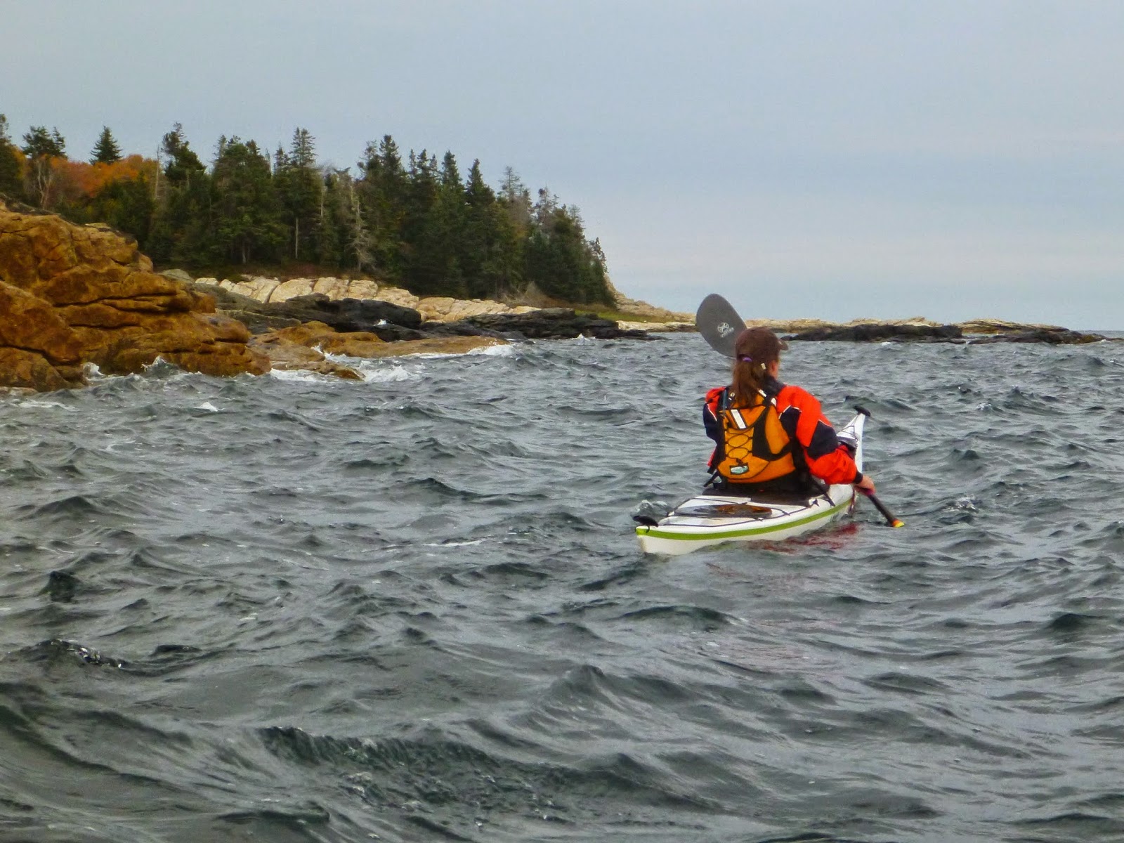
Rebecca was paddling a Delphin and had some particularly graceful moments. Here she's pivoting into the incoming surf, swinging her stern around toward shore. A moment later, she caught the same wave and surfed it away from the rocks. Small waves, big fun.


We headed over to Outer Heron Island and the White Islands, both part of the Maine Coastal Islands National Wildlife Refuge. They're both closed for bird nesting earlier in the year, making this a good time to check them out.


Tall, whitish cliffs drop steeply into the sea around the southern end of White Island. At the top, an old chimney still stands like a monument.


We landed at a pocket beach on the north side and followed rocky ledges up to the top. The sun was sinking toward the western horizon, dropping out of the clouds and giving us a brief burst of color, before the clouds moved-in again, wispy lace and mackerel scales with a distinct wintery look.


I had hoped I might get a photo or two for the guidebook- maybe one that really conveyed the feeling of Damariscove Island. We headed back across the channel, aiming for the tiny splotch of red where we'd parked the car. I felt I had a few photos and some new details as well. I've been editing the guidebook, compressing it and weeding-out extra words. It feels like a process that will never end, even after the book comes out, and in a way, I don't think it will. We were off the water just before sunset.

Monday, October 6, 2014

Tour de' Northern Frenchman Bay


We met Saturday morning at the College of the Atlantic pier: five student leaders-in-training, ready for a weekend trip around Frenchman Bay. The weather forecast wasn't promising: strong winds, 100 percent chance of rain, fog, the potential for big seas, but there was never any discussion of cancelling the trip. The students' stoke level was high. They'd been working hard all week on academics, but had spent Wednesday out with Nate, getting  a good look at the watery part of their neighborhood.


Nate and I have led several COA trips in the past, but this year Nate has made it one of Pinniped's goals to establish a training program for student leaders, so that students at the college will be better able to safely get into sea kayaking, led by their peers. After all, the college has an amazing location on the site of the former Turrets estate, overlooking Bar Island. The students are a great group, all alumni of a college in Victoria, BC, where they've had opportunities to get out paddling and hiking and hone their camping skills.


We headed into the fog and followed the Porcupine Islands. Along the way, we took turns leading the group and navigating, getting a sense of what it feels like to lead and be led, and the different ways to go about it. But we found ample opportunity to play along the way.


We ate lunch at Rum Cay and headed around Long Porcupine. 


The seas were fairly small- a good day to learn one's way around the rocks and ledges. But of course, one of the number one lessons to be learned is that no matter how small the seas appear, there's always a bigger wave out there, and you need to keep an eye out for it.


I'm always trying to see things through students' eyes, to try to understand how this looks to them- if I'm pushing them too hard or not enough. One of the best forms of feedback is a great big smile.


We could have kept playing, but we wanted to get to our campsite on Stave Island while the getting was good. The wind began to increase, and we were expecting steadier rain.


As with most clients, I tried to leave as much of the route-planning as possible to the students, floating an idea here and there and seeing what seemed to catch their interest. When we were looking over the chart on the beach, I mentioned the possibility of going around Crabtree Neck the next day. The marine forecast for the greater area called for 3 to 5-foot seas and 25-knot gusts, and the thought of more sheltered waters was appealing. The Crabtree Neck route would take us up Sullivan Harbor, past the Reversing Falls and into Taunton Bay, where we could wind through Carrying Place Creek to the Skillings River, back out to Frenchman Bay.


That caught their interest. The only problem though, was that it was far- close to 20 nautical miles, and we'd need to start early to catch the tides right. They surprised me and all quickly agreed that we would get an early start and go for it.


The students set-up our dining fly in an old cellar hole, where we ate lentil curry, comfortably sheltered as the wind bent the trees overhead. I have to admit that I like guiding people who cook for me- and we ate well. After dinner, instead of ghost stories around a campfire, we listened to kayaking tales of woe from "Sea Kayaker Magazine's Deep Trouble." Later, in my tent, I listened to the wind whip the fabric and the waves washing onto shore. 


We were all up in the dark, eating oatmeal as the rain pattered on the tarp, and launched at a decent hour. We followed the islands that circle the northern stretch of Frenchman Bay: Stave, Calf, Preble, and onward past the shore of Sorrento to the mouth of Sullivan Harbor.


Not a bad way to start the day at all, but it took a little longer than we'd hoped, so as we made our way up Sullivan Harbor, we began paddling against the current.


Our desire to catch the tides kept us in our boats longer than usual, and just short of Sullivan Falls it had already been awhile since breakfast. I had to ask myself if I was maybe pushing them too hard- if my desire to get around Crabtree Neck was overshadowing the needs of the group. But Sullivan Falls was just around the corner- a good place for a break since everyone wanted to see the falls and have a snack. Plus there was water and a bathroom. It was a big day at the falls. Only an hour after slack, the waves were big and meaty with sharp fangs- not something we wanted to get into right then. After a break, with energy levels revived, we carried past the biggest waves and made our way along the edge, below the Route One bridge and into Taunton Bay. Somewhere in there the rain and dark clouds went away and the day turned sunny. We found the entrance to Carrying Place and headed downstream.


It was good that we hadn't dilly-dallied; the creek was draining and in a few spots we bumped along over a rock or two, finally emerging in a stretch of mudflats around a ledge where we ate lunch.


By the time we made it back to Frenchman Bay the day had turned brilliant, fairly warm- still a bit of wind, but we tucked into the shore along MDI as we made our way back to Bar Harbor.