Sunday, October 28, 2018

West Rattlesnake, Chocorua, The Sugarloaves


At the check-out line, the cashier, a woman probably a few years older than me scrutinized my face and asked me a question, and as usual, I needed to repeat it back to her to make sure I understood: “Am I… over fifty?”  

She smiled. She probably saw my hesitation, as if I still didn’t quite accept that I’d begun to slide into old age, that I might prefer to not admit it, and I didn’t exactly want to be reminded. Was I getting carded? I looked at our groceries and there wasn’t any alcohol, besides, she’d said fifty, and not whatever the drinking age was. Hutch and Shari were ahead of me in line; we were all together, our faces all still red and flushed from an afternoon hiking up a mountain after the first snow. She hadn’t asked them. They looked on curiously. She’d singled me-out; it was that obvious.  I shrugged. “Yes,” I said.

“You’re in luck.” She turned to the register. “You get a discount on Thursdays.”


We took our first walk on Wednesday afternoon, the day after Hutch and Shari had arrived. It was a pretty typical walk to take first-time guests on: West Rattlesnake, a small mountain that overlooks the lake. It’s a bargain hike: a relatively short and easy walk with the reward of a massive view at the top. Aside from being a good warm-up hike, we get a good look at the neighborhood from up above. The lake spreads below us, islands recognizable as if from a vividly colored map, with an autumnal red and yellow arboreal border. Rebecca and I like to take our friends up here and just stand for a bit and not say anything, not point anything out, just watch our visitors take it in and try to remember what that was like. But then we’ll point things out, just to get oriented: that lake over there to the left is Winnipesaukee. That mountain off in the distance to the west? That’s Moosilauke. We sat for awhile as others came and went, just taking it in until finally it occurred to us that maybe we should head back down.


On Thursday Hutch and Shari and I headed up Mount Chocorua, which quickly became ‘Chocula’ instead – it’s only a few letters off, and the name of the vampire-themed cereal is much easier to pronounce. The hike began in autumn, beneath a canopy of vivid green and yellow foliage, but progressed into freshly-fallen snow that became ankle-deep by the time we stopped at the Jim Liberty Cabin for lunch.


The cabin is there for overnight stays, first-come, first-served, with nine wooden bunks and decades of graffiti scored into its woodwork. Heavy chains secure it to the ledge, and there’s a hint of a view between the spruce trees encircling the small meadow around it. It all lay beneath a heavy, wet layer of snow, which still clung to the spruce boughs like sugar frosting on a gingerbread house. I remembered a visit from many years ago in which my friends and I spent a night there. Tents were pitched in the ‘yard’ and the cabin was crowded, dominated by the loudest occupants, drunk and boisterous, and it reminded me why I tend to avoid such places. But we had it to ourselves and we ate our sandwiches on the porch steps, admiring the fresh snow.


We progressed up the trail, and within minutes paused to turn around. We all gasped involuntarily when we saw the view. Whatever our expectations, they were surpassed. The nearby trees lay beneath heavy snow, while down below the white frosting tapered, blending with bright reds and yellows and greens, a study in contrasts. It had been snowing intermittently still, but sunbeams bore through the grey layer of clouds, lighting startling patches of color. 


This alone was worth whatever effort the hike had taken, which was good, since not much farther up the trail we decided to head down without reaching the summit. Had the snow been deeper, we might have been able to find traction along the path, but the unstable single layer of snow tended to simply slide away below us on the steeper parts – with consequential drops beneath them. Microspikes wouldn’t have been effective, but it hardly mattered; that revelatory glimpse buoyed us as we walked down, and later it carried us through the grocery aisles so that even the cashier’s reminder of my advanced age only further elevated the mood.


The next day, after a late morning, we were in the mood for another bargain hike in a different neighborhood, so we drove up to the north side of the White Mountains to a pair of smaller mountains called the Sugarloaves. Again, we began in autumn and gradually ascended to snow-covered ground, although not nearly as deep as the previous day’s. It was still chilly, below freezing, but the wind had died and the sun shone with hardly a cloud in the sky. 


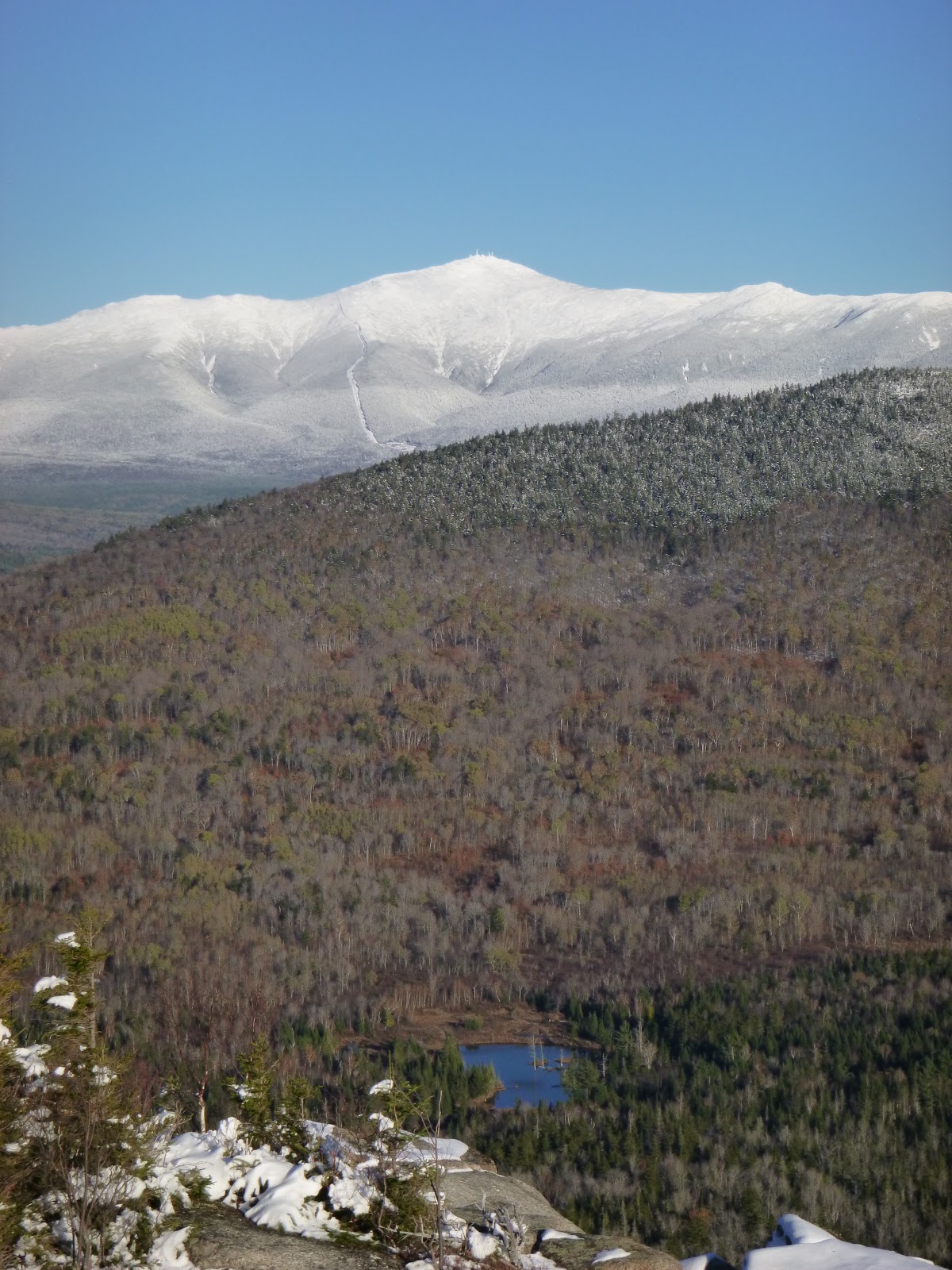
This is another true bargain hike, and the snow made it even more so, since the surrounding peaks, including the Mount Washington massif, were sparkly white, frosted like a heavily-sugared breakfast cereal. And you get not one, but two stunning mountaintop views, from both North and Middle Sugarloaves. We looked up at considerably higher peaks I’d been too fairly recently, like North Twin and Mount Hale, where the views are not nearly as overwhelming.


We returned to the trailhead not long before sunset and grabbed coffee at a gas station for the drive home, which took us through Franconia Notch at dusk, listening to nostalgic oldies on the radio – songs from the eighties and nineties that had been popular, it seemed, not so long ago, soundtracks to fleeting episodes from our pasts.

Notes:
We got to know Hutch and Shari over the summer when they worked with us at Old Quarry. They’ve spent most of the last six years living in a tiny ‘canned ham’ travel trailer, traveling all over and documenting their adventures on their blog, Freedom in a Can.


Info on these hikes can be found both in the AMC White Mountain Guide and in AMC’s Best Day Hikes in the White Mountains by Robert N. Buchsbaum.


Tuesday, October 16, 2018

Autumn Leaves on Mount Avalon


I’d been walking a short time, gazing down at my feet stepping through a golden-yellow layer of recently-dropped birch and aspen leaves, when it occurred to me that my pace was falling in step with the rhythm of a tune moving through my mind: Autumn Leaves. Aside from the obvious reference to my surroundings, the tune set a comfortable, relaxed pace, a good way to start a hike, and I didn’t mind. I seem especially prone to getting these ‘earworm’ tunes stuck in my head, following me for miles while I paddle or hike, and they’re not always so unobtrusive. Sometimes it’s the last tune on the radio en route to my adventure, but it may also be a recurring theme, like the instrumental disco anthem that followed me for much of the Maine coast on our Upwest & Downeast paddle last year. More and more it seems my earworm tunes lack lyrics, which I find agreeable enough, especially when this figment of my imagination drives the constant, multi-pitched ring of tinnitus, another made-up sound in my head, into submission.


I was headed up the Avalon Trail in Crawford Notch, which is a bit of a bargain hike to get to a view of the valley. But I was lured by the proximity of a couple of taller mountains, Mt Tom (4051’) and Mt Field (4340’) upon whose flanks Mt Avalon (3442’) is situated. Though I wasn’t expecting huge views from the taller summits, I was in the mood to walk, and it was a warm sunny day, probably the balmiest we’d see in October.


The tune cycled through my head, mostly drawing from the version I’d heard the most, from Cannonball Adderly and Miles Davis. I’d never known the song’s lyrics, but somehow the instrumental versions convey the bittersweet sense of longing and wistfulness at least as well as any words could. I don’t know how that works – that a simple tune seems to embody ideas and feelings without the help of spoken language, but it does. And since a melody is more universal than lyrics, it seems to apply itself to your surroundings more readily. The warm day made me more aware of its passing, wistful for all the summer days now past, and the leaves were probably as bright as they would be before the next storm knocked them down and the season rounded the corner toward winter.


I’d been in New Hampshire for about a week and I’d gone for a couple of other hikes as well. The first was not well-chosen for my first hike after a summer of paddling and little hiking. I headed up North Twin Mountain (4761’) with aims of getting over to South Twin (4902’) but I never quite got into it. It felt like a lot of work. My leg muscles burned with the uphill effort and I ended up with a headache (perhaps a bit dehydrated?) that took away from my enjoyment when I got to the summit of North Twin, which was socked-in by dense clouds. I finally remembered the ibuprofen in my first aid kit, which helped, but I had to admit I wasn’t really enjoying it, and headed down after a snack on North Twin.


For my next hike, I lowered my ambitions considerably, and had a gorgeous warm day. It was the Friday before Columbus Day weekend though, and the Kancamagus Highway was busy enough that I felt annoyed by the time I parked at the trailhead for Hedgehog Mountain (2532’). 


Despite the tailgating traffic that jammed all the scenic turn-offs, there were only six cars in the lot. I’d been to the trailhead before, and had one of those uncertain moments, unsure if I’d taken this hike before, but if I had, I’d forgotten it well enough, and it all seemed new and wonderful. You don’t have to go far before you step atop open ledges for expansive views of the 4000-foot mountains surrounding this little peak. I only ran into a few other people, but the trailhead lot was full when I returned, and I resolved to forego hiking until the weekend was over.


I did, however, drive to southern New Hampshire to buy a used canoe, and since I was in the neighborhood, thought I’d take a hike up Monadnock, a small mountain I’d climbed many times in my youth, when I lived in that area. As I approached the road into the state park though, I saw that it was closed off by the police – no room for more cars. They were doing me a favor, since such crowds would drive me nuts. Besides, I wanted to try the new canoe. In between hikes, I’d been out for a few short paddles, in kayak and canoe. They’ve been nice, but when I’m in New Hampshire I tend to think more about hiking.


The highlight of the Mt Avalon Hike was Mt Avalon, even if it doesn’t feel like much of a summit. There were also some enticing waterfalls, not far in from the trailhead. Mounts Tom and Field were fine, but you know you’re at the summits mostly due to the piles of rocks marking them, with limited views nearby. The top of Mt Avalon feels more like an open ledge on the side of Mt Field, but has by far the best vantage. A few other hikers came and went while I sat there, eating my sandwich, watching the cloud shadows pass over the brilliant patchwork colors in the notch. I could see our red car parked beside Route 302 down below, and not far away, the bright red roof of the Mount Washington Hotel. The summit of Mount Washington was shrouded in clouds, never revealing itself.


I overheard a couple counting the 4000-footer mountains they’d been up, and I suppose that personal challenge (much like the MITA 30-In-30 Challenge I’d embarked upon over the summer) brings a lot of hikers to these and other peaks that, while they offer some nice hiking, have underwhelming views for the effort involved. I joked with the couple that there was nothing wrong with the views; after all Mt Tom had a nice spruce tree with some lovely mosses surrounding its base, as cultivated as a terrarium. And of course there were those piles of rocks. Mt Field had a view of Mt Washington from a small opening in the trees.

When hiking to mountaintops I often remind myself that Thoreau wrote in his journal “… It is remarkable what haste the visitors make to get to the top of the mountain and then look away from it." It’s just a reminder that there’s more to a mountain than the view away from it, but it can also be a bit of a rationalization when you’ve just sweated to a mountaintop and there’s not a lot there that makes you want to linger. But Mt Avalon’s views were good enough to make me linger, and for just a little while forget the tune in my head.


Notes:
In addition to AMC’s White Mountain Guide, I’ve been using AMC’s Best Day Hikes in the White Mountains by Robert N. Buchsbaum. The book helps winnow the nearly endless hiking options in the White Mountains down to a few of the more attractive ones. In addition to the nuts and bolts info in the White Mountain Guide, there’s a bit of the author’s take on what it’s like to hike in these spots, why one would want to go up one trail instead of another, as well as historic background and natural history.


Wednesday, October 3, 2018

The Last Five


Parked beside the road at Reach Beach, I took my kayak down from the car, and placed it on the sand, just a dozen or so feet away, where the water lapped at the bow. It was nearly high tide on a placid mid-afternoon, the last day of September, with three or four hours before dark, and I had a goal: to land on the five Maine Island Trail islands at the east end of Eggemoggin Reach. To get to them I’d need to paddle a loop of about ten miles and not dilly-dally too much along the way. I loaded my boat and headed out.

It had been at least a week since I’d last paddled, and I could tell; it felt like work. Maybe it was that I was so focused, paddling faster than usual, thinking about how I barely had enough time to cover the route before sunset, but how I really wanted to get to these islands. These would be the final five islands I needed to land on to meet the Maine Island Trail Association’s 30 in 30 Challenge. The deadline was still a week away, but we would be heading to New Hampshire for a bit, so if I wanted to meet the challenge, this was my chance. 

Campbell Island, #27
If you’re just tuning-in, the 30 in 30 challenge is MITA’s way to celebrate the Trail’s 30th year, offering a rare, special edition piece of headwear for those who land on 30 islands before Columbus Day. All you have to do was set foot on the island and then document it. Man, I really wanted that hat. (Of course, what they’ve failed to mention is that the hat is what some would call a lampshade with the number “30” scrawled on it with Magic Marker). It was rare for me to have such a goal. Most of my personal, non-work paddling this year had been fairly leisurely, mostly to get away from it all, in pursuit of hammock time as much as exercise. I’d become a bit of a slacker.


The mountains of Mount Desert Island rose to the east, beyond Blue Hill Bay, their peaks cloaked in a low layer of cumulus, but here it was absolutely clear and sunny, a crisp autumn day with a mild breeze. A couple of small sailboats crisscrossed Greenlaw Cove. I weaved among near-shore rocks below the houses on Oak Point. I realized I was still thinking of the goal more than enjoying the moment, maybe not enjoying it as much as I could, but whatever – I had places to be. Ahead, at the mouth of Fish Creek lay Apple Island, and I thought ‘that will be number 26.’ I looked over at Campbell Island, off to my left and thought ’27.’ I looked at my watch. 

Sheep -Stinson Neck #28
But then, up ahead, a seal popped its head above the surface and looked at me. The water near it roiled with movement, and I steered toward it, arriving amid a school of densely swarming foot-long fish. They swam beneath and turned, as if of one mind, like a cloud moving through the water, catching silvery flashes of sunlight. The cloud moved to the surface, breaking through with fins and tails, a mob of fish, and circled around. This was unusual. If I saw fish around here, which didn’t happen often, they were usually finger-sized, corralled into shallow coves by terns. These were big, fat fish, thousands of them, and I sat floating for a while, watching. I thought vaguely of my schedule, my need to get to five islands before dark. And I lingered a bit longer – so what if I came back in the dark? If need be, I had lights. 

Sellers Island, #29
I continued toward Apple Island, perhaps a bit slower-paced than before. But I felt more ‘there.’ Maybe then I felt some of the stress of the last week begin to slip away. As our season at Old Quarry wound-down, we got the news that we needed to move out of the space in Stonington where most of our belongings were stored, and Rebecca would need to find a new studio. We’ve been transient for nearly four years now since we moved out of our gallery and apartment in downtown Stonington, and we’ve lived either in outfitter housing or in house-sits, but this approach was only possible because we’ve lived with a tiny fraction of our belongings, the furniture and most other household items stored away. So for more than a week we’d been moving from one storage unit to another – an exercise in futility if there ever was one – and to a new studio space for Rebecca.


I arrived at Apple Island and walked around, looking for a photo to document my brief visit. It can be tough to find something interesting when you only hop out of your boat for a few minutes. I felt hungry, but I didn’t have any snacks – I usually paddled with granola bars stashed away in various pockets, but this time I had none. But there were apples on the trees. The lowest had been eaten by deer, but I found a stick and knocked one from a higher branch, and it tasted perfect: sweet, crisp, as fresh as it gets. So I knocked down a few more and stashed them in my day hatch.

Apple Island, #26

I went on to Campbell Island (27) and Sheep Island - Stinson Neck (28) and then headed across the Reach, where I landed on Sellers (29) and finally Little Hog (30). Somewhere in there I found my rhythm and the paddle strokes came more naturally, with less effort. Then, with the current against me, I stayed on the Brooklin side of the Reach, skirting the edges of Babson and Little Babson Island to where I could paddle against a little less of the flow to cross back to Deer Isle. The sun was sinking in the west – right over Grays Cove. I pointed my bow below it and headed back.

Little Hog Island, #30


Notes:
There’s still a few days to take part in MITA’s 30-in-30 Challenge. You too could wear one of these hats.

In mid-September, I paddled a tandem with Joseph Rosendo, host of the PBS series Joseph Rosendo’s Travelscope. We were followed by a film crew in the NIGH DUCK who recorded our conversations, including a stop on Hells Half Acre, where I had a lot to say about the merits of the Maine Island Trail. The episode will air sometime later next year.

This wasn't our year for doing big kayak trips, but we were able to enjoy the trips of others vicariously, and sometimes offer a little assistance. Cheri Perry and Turner Wilson, who together travel the world teaching, mostly Greenland skills, under the auspices of Kayakways, came through Stonington on their way downeast on a long coastal trip, and we just saw them a few days ago while they were driving home. I saw bits and pieces about their trip on Facebook, and hope someday to hear more about it.

In addition to moving stuff between storage units and studios, we've moved from Old Quarry into a an apartment we'll be sitting until next summer. It overlooks Stonington Harbor and is a short distance from the launch there.


-->