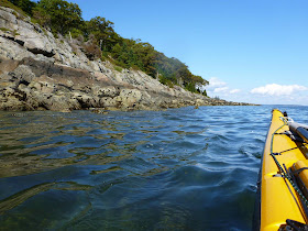
The sea is calm, the air clear, the distant hills sheathed in mild haze. On Crotch Island, the granite-cutting machinery hisses, blending with the chug of lobster boats- the tinnitus of greater Stonington that starts to fade as I cross Merchant Row. Diesel fumes waft from circling lobster boats not far off. After an hour, on Wheat Island, I take my first quick break- ten minutes- and soon I’m paddling along the east shore of Isle au Haut, below the hardwoods and steep dark bluffs just past Richs Point.

It would be easier, with so many miles ahead, to stay offshore, pointing my bow for the most distant headland, skipping the particular contours of the shoreline. But I’ve done that before. When you’re alone, it’s easy to make that snap decision- the slight turn of the bow that changes your course without really thinking about it- to get in close and follow the shore. It may take a little longer, but my mind is occupied- as much as it can be occupied, looking at rocks and houses, shifting my hips to make an occasional tight turn between rocks. Paddling further from shore is like driving on the Interstate, counting down the miles. Following the shore is more like taking a walk.

For a couple of miles I alternate between shore and ledges as a mild swell builds, occasionally amplifying into breaking waves over the rocks. The houses on shore become less frequent, as do potential landing areas. There are no people on shore, and only far-off lobster boats on the water. After about three hours of paddling, I round Eastern Head. To the south: open ocean, an oil tanker on the horizon. Ahead of me, the cliffy southern end of Isle au Haut curves inland and back out to Western Ear. If I paddled directly across, I’d cover almost two miles, but what fun would that be?
Instead I paddle about twice the distance, following the shore to where a dozen or so houses overlook Head Harbor. No one is around in the middle of this Wednesday in September; a quiet place on a quiet island. The hum of Stonington is worlds away. As I leave the harbor, there is only the sound of surf.

This shore is perhaps the crux of the trip: the farthest from Stonington, the most exposed to ocean swell, and the most spectacular. Because it is part of Acadia National Park, it is also the wildest. The cliffs look almost white in the afternoon sun. It seems right somehow that it takes some effort to get here. I’ve paddled maybe a dozen miles, with over a dozen more to go, and as far as I can tell, I’ve got the whole southern end of Isle au Haut to myself
But I need to think about getting back. I take a quick lunch break by Western Ear, gazing out toward Saddleback Light and Brimstone Island, and turn north. With the breeze and the swell behind me, this stretch goes by easily. And it’s a good thing. I’m feeling a little tired, and still have a ways to go, but I take a tour around Moores Harbor, simply because I’ve never paddled there before. I pause below Robinson Point Light for a snapshot, and ride the current through the thorofare, past town on the right, Kimball Island on the left.
On Kimball, some friends have finished work and I watch them get into the Nanatoo and cast off lines. A few moments later, they’re passing by, waving. I have just enough time to get back before sunset.


No comments:
Post a Comment