 |
| Meeting the locals at Cobscook Bay |
We camped at Cobscook Bay State Park, and after my lesson on Monday we
went in to Eastport to poke around in a way that we really couldn’t when we
were camping out of our kayaks. The town seemed quiet, recovering from the
weekend festivities – a Pirate festival, and there wasn’t much going on. We
strolled the empty sidewalks, peering in windows: antique shops, galleries, a
marijuana dispensary, a pet store… We looked at the statues and the waterfront
and pondered the menu at a restaurant before deciding to return to the
campground to make dinner.
But Tuesday we had all day to explore and the weather was
fairly calm and warm- almost hard to believe how nice it felt. Like summer. We
launched at Baileys Mistake, at a launch mostly used for the 8 or 10 lobster
boats that moor nearby. There’s not much parking there along the roadside-
barely enough for the fishermen’s trucks and trailers, so at this point it’s
not really a dependable launch for kayakers, but I heard it was being acquired
by a land trust. Hopefully this is true and they will develop the parking
enough to accommodate both fishermen and recreational boaters. The launch adds
considerable possibilities to Bold Coast paddling – easier access to (or a
bailout from) the stretch between Moose Cove and Quoddy Head (Route #2 in my
guidebook) which includes Boot and Eastern Heads, cliffy sections of coast with
plenty of nooks to explore if the seas aren’t too big.
We paddled out of the harbor and soon exchanged our caps for
helmets so we could get into some tighter spots among the rocks. The mild swell
felt perfect for some gentle play, and we made our way along the shore slowly,
looking for small challenges. We hadn’t done much paddling like this for
awhile. The last time we’d passed here we’d been offshore in a dense fog, a
thirty-four mile day that afforded us little time or energy for anything beyond
getting to our destination. Today, with no destination, we paddled our barely
loaded, nimble Delphins – the opposite of the sort of paddling we’d done most
of the summer, and we felt playful, cut loose, remembering how it feels to make
a tight turn through a slot or let the surf take you over a ledge, simply
because you can.
Currents get to be fairly consequential in this area, but
for the first stretch we noticed very little current close to shore- not even
eddies. We rounded Boot Head near mid tide though, and with the increased
mid-tide current and the concentrated flow off the headland, the conditions
were getting livelier. As we took a break on the beach at Boot Head Cove, we
watched the surface turn into acres of whitecaps- true to form for the Bold
Coast. I’ve heard plenty of sweeping statements about the place, but the most
accurate and useful one is that things can change here pretty quickly, and
often, dramatically.
The paddling was really no more difficult though. For us it
mostly meant that our long-period small swells had been replaced with
short-period bouncy chop- not really conducive to much play along the shore.
That was okay- we’d had our fun and now it was a short paddle back to the
launch. We were still hoping to get-in a hike.
Last month as we paddled past the Cutler Peninsula – another
stretch of awesome cliffy shoreline, we saw some hikers atop the bluffs and
wondered how they’d managed to get there. Chatting with some local walkers on
another trail, we heard about a trail that goes out to Western Head in Cutler,
down near the end of Destiny Bay Road, and we thought we’d give it a try. We
weren’t too surprised to find a 247-acre preserve owned by Maine Coast Heritage
Trust, preserved since 1988. It has a small parking area- maybe room for
5 or 6 cars, and maybe it’s good that it’s a well-kept secret, since it is an
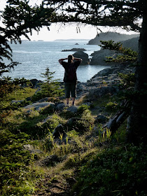
absolute gem. A 3.5-mile trail follows the Little River out to the head where
it loops along the bluff-tops with views out to Grand Manan and southwest
toward Cross Island. The trails are well-maintained, and you get some nice
glimpses of Cutler Harbor as well.
Notes:
Route #2 in AMC’s BestSea Kayaking in New England covers the area between Carrying Place Cove in
Lubec and Moose Cove. The launch in Baileys Mistake is not included, but if it
really is being acquired by a land trust and the parking situation improves, it
will make it into the next edition. Conditions during today’s paddle were mild,
but the guidebook has much sterner warnings as well as strategies for paddling
this area. One of the most volatile and remote areas of the New England coast,
it is not a place for inexperienced or unprepared paddlers.
Here’s a link to some more info on MCHT’s Western Head
Preserve. And here’s a link to the MCHT website, which does have information on
their other nearby preserves, but not this one.


Just read your article. Good one. I liked it. Keep going. you are a best writer your site is very useful and informative thanks for sharing!
ReplyDeleteMy blog: fishing reel