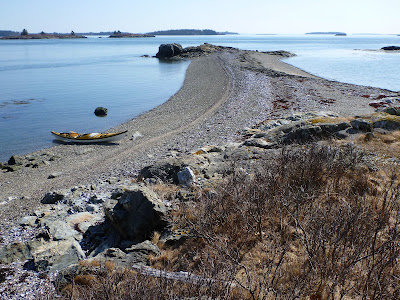
Friday, March 23, 2012

Sutton, Little Cranberry & Baker Islands

Osprey nest at Sutton Island

The forecast for Thursday was amazing: clear, not too windy and air temps... in the high seventies to low eighties! In March! Despite these overly-hot temperatures, Nate and I had plans to get out. With the air forty degrees warmer than the water, we figured we might be roasting in our drysuits, but we’d tough it out. Lighten the base layers and skip the gloves... dip your hand in the water every now and then as a reminder. This weather could prove more dangerous than on colder days, since it will probably lure unprepared paddlers out onto water that will kill them if they capsize. Just last weekend, unprepared paddlers died on Lake Michigan and in Ontario, probably due to the cold water. 

I don't know what to say here- yes, we like to put our bows into things.

Nate and I drove to Mount Desert Island and launched from Northeast Harbor, where we headed-out past the lighthouse on Bear Island and on out to Sutton Island. A mile-long, the privately-owned island has twenty or so homes connected by wooden boardwalks. It's really too charming for words, so that's all I'll say until I get a chance to walk around it.


We arrived at the east end as high tide neared. Despite all the houses on the island, most of it feels fairly undeveloped, especially the east end, where great rocky fins and dikes extend down into the water, creating chasms and passages to paddle through.


On the northeast end of Little Cranberry Island, we decided to check-out a feature that we’d paddled past before without noticing. Why is Marsh Head called Marsh Head? Well, it may have something to do with the marsh. We did a ten-foot portage to get in, then followed a winding, creek-like path to the east end of the island.


From the calm waters of the marsh, we heard a roaring, hissing sound just beyond the trees to the south, and it took a moment to recognize the crash of surf. The marsh ended at a deposit of rock and sand. Again, we got out and carried the boats just over the hill, launching into small waves on the east end.


We had plenty of time to cover the six or so miles out to Baker Island, but we dilly-dallied: osprey nests, winding rocky passages, a hidden marsh. These are the things that make it fun, that keep a day of paddling from turning into an accounting of passing miles.


On the other hand, by the time we arrived at Baker, we didn't have much time for dilly-dallying. We faced more wind, and the fairly minor swell amounted to some decent waves here and there as we paddled around the southern side. 


At one point, I looked over at Nate and thought he was paddling a little close to the ledge right beside him. Then one of those sneaky-big waves came in and dropped him on top of the ledge. This circumstance happens often enough that it must have some sort of cool name... but I don't know it. This time he had to get out of his boat and find a better spot to relaunch.


Then it was time to boogie back to Northeast Harbor. As we passed the islands, the land-warmed air blew across our decks- a reminder of the eighty-degree land forecast. We'd been perfectly comfortable in drysuits, even a little chilled now and then out in the wind and waves. It was hard to believe how warm it felt back at the launch. We rode along in Nate's truck in t-shirts, elbows out the windows... with NPR on the stereo. We picked up his kids at a friend's, where they were squirting each other with a garden hose, and everyone- parents and kids seemed to be congregating in the street... just like us, making the most of a warm day in March.

Thursday, March 15, 2012

Butter and Great Spruce Head Islands


Great Spruce Head Island, Colt Head in the background

The seas looked calm on Monday- only 5-knot winds in the forecast, and warm air- above fifty even. Calm comes in varying degrees. There's "flat-ass calm," which is mirror-like, glassy. Wait, maybe that's "glassy-calm" or "calm as glass." Either way, on the calm scale, the seas were a notch or two above that, but were nonetheless the sort of calm seas upon which you could paddle across Penobscot  Bay.

Seals, west side of Great Spruce Head Island

I didn't have that thought until I took a break on a small cobble beach on the west side of Great Spruce Head Island. I'd launched from Sylvester Cove a couple of hours earlier and paddled out past Hardhead and along the southern shore of Butter Island before crossing over through the Barred Islands to Great Spruce Head. But there I was, half-way across the bay, looking over toward the southern end of Islesboro and the Camden Hills beyond- all looking fairly close. As cool as such an undertaking would be, I didn't have it in me to paddle thirty miles and get home late. I like meandering too much.

Southern Point, Great Spruce Head Island

Great Spruce Head Island was the summer home of photographer Eliot Porter and his brother, the painter Fairfield Porter, so for me, paddling past their haunts has the feel of a pilgrimage. Their island scenes are easily recognizable, even if the trees have grown-in over the past... I was going to write "fifty years," but the Porters spent their first summer on the island in 1912- a century ago. In his book Summer Island: Penobscot Country, Eliot Porter tells the story of how the island became a part of their lives. Through his photographs and stories, Porter describes getting to know his island and the people in the area, as well as excursions to other parts of Penobscot Bay.  He found Stonington to be "the most engaging today, and in many ways the most attractive..." of Penobscot Bay towns. That's good to hear, but as I read his book, I felt envious of his family's island. Fortunately, the family generously allows the public to land on what signs designate as a "privately-held nature preserve".

The view from Montserrat Hill, Butter Island, looking toward Eagle Island
Tom Cabot bought Butter Island back in the 1940s, and like so many of the islands that he bought and gave to land trusts or to the state, he shared it with the public. By the 1990s, during summer months the island often received over 150 visitors a day, and this use took its toll. And it made it tough to carve-out any private space when the family built a house on the northernmost hilltop. Caretakers had to call authorities to eject boatloads of campers who camped anywhere and cut-down trees to fuel their bonfires. At one point, Tom Cabot found a squatter living in a makeshift home built in a spruce thicket (something I would have done in my twenties... actually, something I did, but that's another story).


So now there's a designated public area on the east side of the Island. You can land on Orchard or Nubble Beach and hike up to the top of 150-foot Montserrat Hill, where a granite bench memorializes Thomas and Virginia Cabot. The view is probably akin to what may have been seen from many of these islands a hundred years ago, back when the trees were cut for fuel or lumber and sheep and livestock kept the grasses munched-down. For me, it was a view of my paddle home, out past Hardhead on calm seas back to Deer Isle.


Saturday, March 3, 2012

Snow on Steves


After not much snow here this winter, we got a pretty good storm. Honestly, I needed some days of nasty weather to get some work done that I'd been putting off. The next afternoon I was in the gallery when I realized that the wind had dwindled, the sun had come out, and it wasn't too cold. Work could wait; I packed my gear quickly and headed out. After all, I could hardly remember the last time I paddled among the islands with fresh snow on them.


I had only a couple of hours before sunset, so it seemed only natural to head out to Steves Island. I might even get a jump on my duties as a MITA island adopter.


Well, even in the summer, I don't usually have a lot to do to look after Steves Island. Most of the campers who stay there take good care of things, probably packing-off more garbage than they arrived with. I came across some of the usual fishing garbage, but otherwise, the snow made the island feel even more pristine than usual. A few treetops had been blown down and blocked the trail. The campsite on the western beach will get a little more starlight than before.


Mostly, I just walked around and looked at things.


And then I paddled home as a new front moved-in.