Showing posts with label Bar Harbor / Frenchman Bay. Show all posts

Tuesday, September 5, 2017

Frenchman Bay to Stonington: The Last Stretch

-->

If you're just tuning-in, this post covers the last couple of days of a two-month meander along the Maine Coast.

After the last blog post, we paddled the last forty nautical miles, from Frenchman Bay to Stonington, to finish the trip in two more days. 
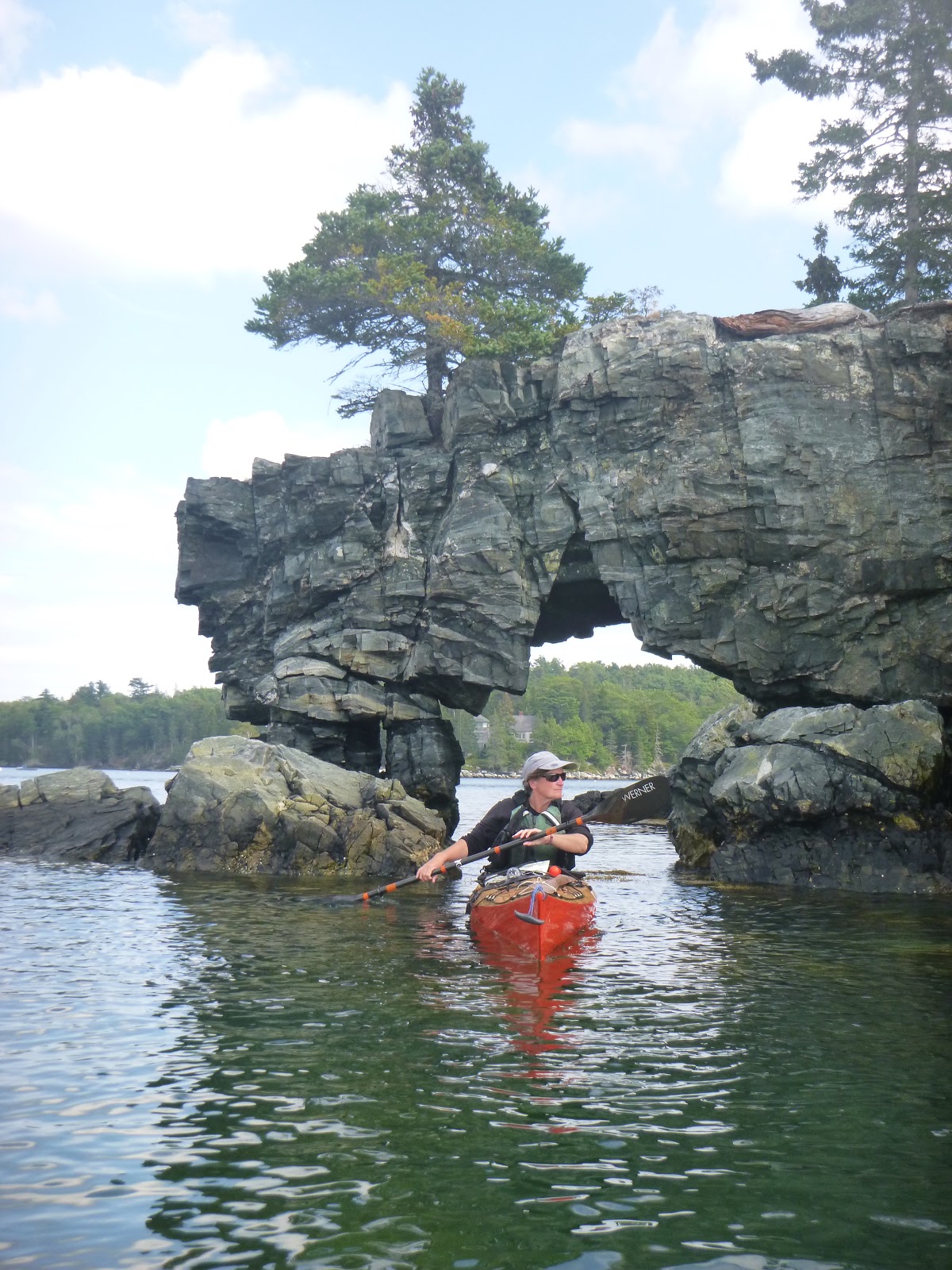
We still needed to stop in Bar Harbor for some groceries and one last water fill-up, so we followed the Porcupine Islands in, stopping first for a quick break on The Hop. The fog had just cleared and the sun shone through- a good day to see the mountains of Mount Desert Island rising before us, welcoming us back to our neighborhood.


The seas were still pretty lively though, and we paddled into a strong west wind. A big cruise ship lay at anchor in the near harbor, while an odd private ship dominated the water southeast of Bar Island. It carried a full-size sailing yacht on one side, ready to be lowered to the water. 


Later I learned that it belongs to a Russian oil guy – the word ‘oligarch’ is tossed around to describe him and his 90+ million-dollar toy, that also carries a large motor yacht on its stern deck, and a helicopter that transports a Range Rover. Apparently the ship is still there, still the talk of the town.


Despite the strong winds in our face as we made our way from one Porcupine Island to the next in the lumpy wind-against-current seas, we encountered a guided kayak trip led by one of the guides I’d trained in June. I’d already been thinking that if I were guiding, I’d be taking the more sheltered paddle along shore to Compass Harbor, but I was not surprised. They were flying along downwind, and when the guide said hello, he said they were just going to “peek around this island up here,” as if I might have some thoughts on his choices or the task he would now have of getting these people back to the launch against the wind. Of course I did, but after nearly two months of not guiding or teaching people, I just smiled, happy it wasn’t my job that day.


Tourists stood on the town beach, doing what tourists on beaches do: staring down at the wrack line, skipping stones and taking photos. One man was so engrossed in his attempts to skip a stone that his rock nearly hit me. We pulled our kayaks up and I went off to get water and groceries, plunged briefly into Bar Harbor tourist chaos. Is it possible, that among all these clean, teeming hordes in their new Bar Harbor sweatshirts congregating on the sidewalks seeming to not know where to spend their money next, that I felt a private smug satisfaction when they glanced at me wide-eyed and quickly looked away- that I secretly reveled in my three weeks with no shower grime and my sun and salt-streaked skin? It is possible. After our mostly-alone Downeast sojourn, this was a new, but not unexpected sensation; not really where I wanted to be, but a sensation just the same.


We ate our customary pint of gelato on the beach and continued on our way around the north side of MDI, eventually re-encountering that strong west wind and a current that, thanks to our taking too long in Bar Harbor, had turned against us. We ate lunch on Thomas Island and continued-on beneath the bridge, where slow-moving traffic was backed-up for some distance. That last stretch, with our campsite more or less in view, was a slow slog.


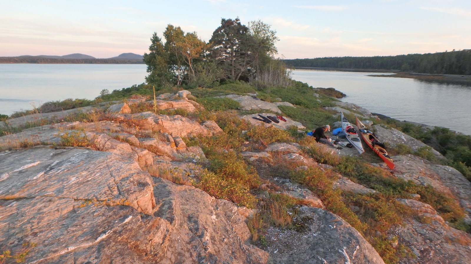
Which was why it was so great to arrive at our last campsite of the trip, a tiny state-owned island called The Hub, and get our camp set-up one last time. We arrived at low tide, and began the work of carrying our gear and boats up the steep rocky ledges. But we’d spent all this time getting better at it, and knowing this would be the last such carry of this trip, performed the task with momentous care. Yes, we wanted to get through this and finish the trip, but we also wanted to hang-on to the moment as much as we could. Though the sun had been gradually setting earlier each night, it had begun to feel like things were speeding-up, the days growing quickly shorter, and we knew that time would pass and this would soon be a vague memory. We stayed out on the ledges well after dark, watching for shooting stars and satellites, and finally, reluctantly, called it a night.


We decided to end the trip at Old Quarry and we spent that last day paddling, still mostly against the wind, down Blue Hill Bay to Naskeag Point, our route now overlapping with the previous segments of the trip as we followed Stinson Neck out to the Lazyguts and across to Sheep Island. With only a mile and a half left, we took a break on Little Sheep, an island we’ve visited many times, usually on the short guided‘family’ trips with kids. The day had begun hot – one of the hottest so far, but the sun had sunk low enough that with the wind I began to feel a hypothermic chill, and I added a layer for the final stretch.


We arrived at Old Quarry on one of their busiest days of the summer. The area above the ramp was a solid mass of uncleaned boats. Much of the staff had just left, returning to college, and the remaining crew had been multi-tasking all day. We learned that our small travel trailer, which we’d loaned for the summer, was vacant, so we carried our gear up to it. I checked my messages and found one from Vicki, who offered a ride to our car after she was done at the library. I called her and heard the background hub-bub of a post poetry reading crowd, and she told me she could pick me up as soon as the crowd left. I felt like I knew the quality of that background chatter well – the same chit-chat from a dozen years of art gallery events, with many of the same people. And I knew that a whole new challenge awaited us, that of returning to something akin to a ‘normal’ life after living this parallel fantasy out among the islands. It would not be easy, but that’s a story for another time.


Notes:

Much of the area we paddled in this stretch is covered in trips #8,9, 12, 13 & 14 in my guidebook AMC’sBest Sea Kayaking in New England.

I have a short article in the September/October issue of AMC Outdoors. It's about my first Instagram post while camping on an island, this spring, and the mixed feelings I had about it. Of course, since then, I've been posting quite a few photos on Instagram, as an easy way of letting friends know we haven't dropped off the map.


We’re now in Stonington at Old Quarry Ocean Adventures for maybe the next month or so. Stop by, say hi.

As we go through photographs from the trip, we'll be adding more to previous posts.


Tuesday, August 22, 2017

Upwest and Downeast: Almost Done


I nearly titled this 'almost home,' but knew that it wouldn't be quite correct. We'll be back to Deer Isle by Thursday or Friday, and it is about as close to home as we have, other than this feeling we carry with us as we paddle up and down the coast, a sense of being where you should be. We get our mail in Stonington still. We have friends there, and a rented storage space where our stuff is stored and where Rebecca keeps her studio, but no house or apartment or place to live (we've mostly house-sat the last couple of years). We rent a few spots in a kayak storage space by the town boat ramp,  and until summer kicked-in, were regulars at pickleball, twice a week at the Community Center. 

This was our fifteenth summer living in Maine, but it's the first in which I've tasted the sense of joy and freedom that I hoped I'd find when we came here. Much of that comes down to economics. We haven't worked since June. And yet we've spent very little money on this trip. Probably less than we usually do on food,  two nights at a commercial campground... a tank of gas at the beginning of the summer. And of course the usual overhead: health insurance, phone bill... a tank of gas in a car that's been parked all summer.  The storage and studio... subscriptions to unwatched Amazon and Netflix.

We haven't lived in a way that most people would find comfortable. It's been weeks since the last real shower, and pooping into a plastic bag has become surprisingly normal. We've eaten well, including a shared pint of ice-cream in most ports. We're a bit damp much of the time, with a layer of salt that seems to permeate the skin. I do look forward to a long soak in a tub of hot water. Obviously this existence- even as a temporary foray- isn't for everybody. Which is good. We've had little competition for campsites and have encountered amazingly few kayakers, especially those who seemed to be going somewhere or camping.

It's premature to recap the trip, but knowing that we're almost done brings-on a wistful sense of melancholy. All those summers we worked so much, and they went by so fast. Well, this one went by fast as well. Many people tell us this is the trip of a lifetime, and they're right, but all we can think is that we want lots of trips like this in our lifetime, or even that we want our life to be more like this.

Right now I'm sitting on a comfortable slab of rock on the south end of Stave Island, in Frenchman Bay. Rebecca is nearby, painting. I don't know what she's painting- the fog has come in pretty thick, obscuring most everything out there, but a little while ago you could see it rising over the Porcupine Islands with Cadillac Mountain in the background. There's a storm forecast for tonight and we decided yesterday that this might be a more comfortable spot than the ones ahead. I think we also just liked the idea of one more time-out on an island, without rushing back to Deer Isle.

Since my last post, we left Dickenson's Reach, up at the sheltered head of Little Kennebec Bay in Machiasport, and made our way down to Jonesport, where we once again bought a few supplies and refilled water at the Moosabec Variety (you can still rent VHS tapes there too). We continued on to Sheep Island off of Cape Split and spent 2 nights there to wait-out predicted rough seas (don't  think they got too rough, but we were glad to stay there). We identified the nearby home of modernist watercolorist John Marin (the weird-sounding seabird that turned-out to be an alarm system helps give it away) but never got over to see, up-close the bluffs of Tumble-Down Dick Head. It's good to save things for future trips.

On Sunday morning we paddled into Milbridge for groceries and headed out to Bois Bubert Island. From there, yesterday morning, we went around Petit Manan Point, on to Corea and then around Schoodic Point during the eclipse. Quite a crowd there;  it felt as if we were sauntering along the outskirts of a party, where everyone was waiting for the band to start, but had kind of forgotten what they were doing there and hey, the light is kind of funny now, isn't it? And we'll give the eclipse credit for the big eddy that took us all the way here, against the dominant current.

Just after lunch today, we spied two skiffs coming our way, and they turned out to be MITA boats, carrying the Maine Island Trail Association's Trail Committee. We're not on a MITA island, but they were checking things out, and we had a sort-of impromptu meeting right there, discussing such things as the need or feasibility for sites along the Bold Coast. They took our trash away and left us with some extra water. And provided us with more human contact than we've had in awhile, which was welcome.

Over the next couple of days, we'll meander back to Deer Isle- only two or three days and nights, and maybe a stop at Old Quarry for a shower before we pack our gear into the car an head over to a family lake home in New Hampshire, where we have a week to recover a bit while hanging-out with some of the constant people in our life. Then we're sort of transient again. Maybe a little teaching and guiding in September... a dentist's appointment... and maybe some time up in Newfoundland with Rebecca's parents. For now though, this fog has come-in thick and cool. Time for some food.


Thursday, November 17, 2016

Super Moon at Sullivan


When you hear that the next full moon will be a “super moon,” – the closest that the moon will come to the earth in many years, you might think “okay, so what do I do with that information?”

Well, for one thing, there’s just something stunning and gorgeous when the moon looks a teeny bit bigger than usual and you see it coming-up. The evening before the full moon I had a ‘holy-cow’ moment when I looked up from the kitchen table and saw the moon rising over the cove. I grabbed a camera and went outside. For most people, that’s it – it’s something to see, especially when the moon rises and there’s some foreground to give you a sense of scale- in this case, the mud flats of Greenlaw Cove, with less water than usual. Certainly, it would have been cool to be out paddling, and I saw some nice photos on the Internet of people around the world doing just that.


Instead, we went-out for a mid-day paddle in Greenlaw Cove, where we’re living this winter, and forayed along the shore into nooks that would ordinarily be unreachable. Later-on when the moon rose, much of the cove was emptied-out, and it would have been a long walk (or a car-top elsewhere) to float our kayaks.

 
But, aside from the visual treat, the nearness of the moon and its amped-up gravitational pull also translates to an increased tidal range. The range over the past couple of days – meaning the difference between tide height at low tide and tide height at high tide, has been 15 to 16 feet. Spring tides in this area (the tides that occur twice a month, during the new and full moons) tend to average closer to 13 feet.
Higher tide range is evidenced several ways. There’s more water coming-in and going out. At high tide you could paddle in places that are seldom under water, and at low tide you could walk in places that are rarely dry. In addition, that plus-size water volume still needs to pass in and out during the same time period, which means stronger currents.
If you want to experience those stronger currents, go to a place where the moving water is already constricted by topography and depth, like Sullivan Falls. Even without spring tides, a nine-foot range there produces lively water with plenty of surf-able waves. So the morning after the super moon, we went to Sullivan Falls for the flood.


We launched close to mid-tide. The tide had already reached the usual high-water mark, but with three hours before high tide, one could only imagine how the features would all change. Nate immediately slipped down onto some nice waves and rode them a bit before dropping farther down to our more usual play spot. I followed and had my first capsize that I’d had for awhile; indeed, the current shot-through with unforgiving speed- it took only a minor misstep to get flipped around, with little chance for recovery. The water felt cold and fast, but I was only under for a few seconds before rolling-up and discovering myself still facing into the current, only a wave or two back, still surfing. Rebecca went through a similar baptism. And there were more to follow.


We played there for a bit, but the waves seemed to just get messier, so we progressed to another spot. We’ve paddled a lot at Sullivan Falls, including a few days with tides near this range, and we’ve learned that big water volume doesn’t necessarily produce the best conditions for surfing. That’s mostly what we’re doing there: trying to get on waves, facing the current, so we can essentially stay in the same spot, surfing on these standing waves.


But the great thing about Sullivan is how it’s always changing. Variables abound. As the current increases, so does the depth. Waves go away in one spot and evolve in another. Some waves are tall and steep, others are low and gentle. Some develop grabby holes in front of them, and others long, even troughs that allow you to ‘typewriter’ across the crest.

This time, our highlight probably came when we found a set of waves off a point where we’ve never been able to surf before. They were small, but powerful, clean waves and gave us some nice rides- enough time on them that we could focus on our technique and try to improve.


When that spot started to dwindle, we ferried back across the river and made our way up-current before ferrying back again, regaining the spot near the launch where we’d begun the morning- nearly unrecognizable beneath a few more feet of water. This time the attraction was a long, diagonal seam where the water came over a ledge and curled back upon itself. If you get sideways on this wave, and keep your weight strongly on the down-current edge, you can side-surf it, something we’d discovered there a few years ago, but rarely had the opportunity to repeat.


And soon enough that wave also began to disappear. Maybe that’s also part of Sullivan’s attraction, especially with such big currents and rapidly changing features – the ephemeral quality. You can’t step into the same river twice. When you catch a wave, there’s no guarantee it will be there the next time you go looking for it. The super moon’s lure of a huge tidal range draws us there, as much out of morbid curiosity as the desire merely to experience the place in one of its more extreme incarnations. But it’s really just a few hours of playing in the waves.

Notes
We didn’t stick around for the ebb. Three intense hours at Sullivan is taxing, and we had a pretty good idea of what to expect after the tide change. There would be some great waves to start with, but they would develop into massive, but very rough and trashy water with a particularly grabby and dangerous hole (that can usually be avoided). The paddling becomes more a matter of self-defense than merely trying to grab a wave. The morning had been good enough.


And if you're looking for ways to stay warm on the water for the coming months,  Wetsuit Wearhouse is having the biggest sale ever for Black Friday, with over 400 markdowns.

Saturday, November 5, 2016

Yet Another Way to Paddle Frenchman Bay


Yesterday morning I had one of those “how long can I keep doing this?” moments as I rolled out of bed. I ached in all the usual places, but at the end of a long season of teaching and guiding sea kayakers, it felt like my age was catching up with me. I hate to admit that – to blame it on age. It immediately makes me think of some of my coaches, maybe ten years my senior, still hard at it, more so than I. They’re either just tougher than I am, in more pain than I am, or maybe they’ve adapted in some ways to sustain their ability to keep at it. Or maybe a little bit of all of the above.
         After rolling out of bed though, I spent ten to fifteen minutes on some stretches, and started feeling better. I’ve done those stretches nearly every morning for probably a decade, and they help. Maybe I need to do more. Maybe it’s time for an update of the yoga classes I took thirty years ago.


I’d spent the last couple of days with M, who’d come from Tel Aviv and wanted to work on a few things you can’t find easily along the Israeli coast, like rocks and ledges and tidal currents. We told him he’d come to the right place. And since Rebecca had errands in Ellsworth, we had the perfect opportunity to plan a shuttle – get dropped-off at one place and picked-up at another. Nate dropped us off in Bar Harbor and helped us get our gear together while his golden retriever ran on the beach. Nate looked out at the Porcupine Islands: damp spruce beneath a gray, overcast sky. The wind had dropped to almost nothing, and the air temps had risen into the fifties – warmer than they’d been lately. “Looks like you’ll have a good day,” he said.
            I might have suggested that Nate come along, but I knew he was looking forward to getting stuff done around the house and returning to his winter projects in the wood shop. Still, he had that wistful look that we get when we launch someone else and kind of wish we were going.


M and I headed-off into the Porcupines, and it was a good day out there, with just enough swell to create a few challenges. We got into the Keyhole and made our way among the tall chasms on Long Porcupine around high tide. We ate lunch on The Hop, the island barred to the west end of Long Porcupine, where you can sit atop high, meadowy ledges and take-in a view that encompasses much of the south end of Frenchman Bay. M asked me if I went there often and I looked around and nodded.
            “You’re lucky to have this in your backyard,” M said, and I agreed.


We went through the gap between Jordan and Ironbound – the “Halibut Hole” and followed the cliffs of Ironbound's eastern shore. The tide was still high, so we managed to paddle deeply into the caves. I’d started the day demonstrating places that M could get into, but by now he knew the drill. He’d start paddling-in while I waited, keeping an eye out for any jumbo waves. 


When introducing people to rocks, ledges and cliffs, one big concern is that, no matter how much I point-out the need to work on that 360-degree awareness, that hypersensitivity to everything around you, and in particular everything that can go wrong- where the waves are coming from and where they’ll take you, it takes some experience to develop this awareness. There’s always a bigger wave coming and you need to anticipate what that will do to the stretch of water you’re about to enter.


So after M paddled deep into the longest cave, I almost didn’t take a turn – after all, he wouldn’t be getting anything more from my demonstration, and while in the depths of the cave I wouldn’t be keeping an eye out for potential close-out waves. And I knew what to expect. But it would be crazy to not go in; the tide was perfect, waves weren’t too big, and when would I get there again?


I backed most of the way to the rear of the cave, from where the entrance appeared as a massive mouse hole in the cliff face. In the dim chamber, the outgoing waves dragged the rounded cobbles over each other, tumbling them like bowling balls in a giant’s popcorn popper, and then the wave would come, driving into the undercut, bored-out back of the cave and erupt in an explosion of mist that shot all around you. You could feel the booming in your chest, this release of energy contained by a vault of stone, like a bomb going off underground, just behind you.
        It put a smile on my face. I paddled out of the cave, and we headed onward, checking-out every stretch of shoreline, looking for whatever surprises it might offer. 


At the end of Ironbound it just seemed natural to continue southward, across a stretch of open water to the Egg Rock lighthouse. From there it wasn’t much more than a half-hour to the take-out at Grindstone Neck, where Rebecca waited for us as the sun set behind the mountains of Acadia.


We spent the next day at Sullivan Falls. Another day, another story, but probably a big part of why I woke-up feeling beat-up after a couple days of this. I know. Tough job, but someone’s got to do it.

 
The places on this route are covered in Trips #8 and #9 in my guidebook, AMC’s Best Sea Kayaking in New England. As illustrated here, there’s no end to the ways you can approach these routes and mix them up.

The take-out is not really a boat launch and not listed in the guidebook since there isn’t  much dedicated parking, but it can be a useful spot. Just drive down to the south end of Grindstone Neck in Winter Harbor. There’s a wide spot in the pavement to turn around or park, and an old stone bench that overlooks the shore, which is a mix of rocky slabs – probably not an easy landing in rough conditions. No facilities.

Sunday, October 23, 2016

Otter Cove to Bar Harbor (or Riding a Giant, Salty Fart)


The southeast shore of Mount Desert Island encompasses the western mouth of Frenchman Bay, which, even on a calm day, rolls some swell into the bold, cliffy shoreline, creating the iconic features that make a national park feel like a national park: postcard-worthy, selfie-inducing roadside attractions like Otter Cliffs, Thunder Hole and Sand Beach. The first time I paddled this stretch, the crowds of people on shore and the stench of diesel wafting-down from tour busses on Ocean Drive made me glad to move-on to less-celebrated, but perhaps equally stunning shores.

 
But now when I get a chance to paddle this stretch, I just try to get used to the fact that we’ll be appearing in the vacation albums of visitors from around the world, that, having paddled around the corner at Otter Cliffs, we’ve stepped onto a stage extending to Great Head, that we’ve become part of the entertainment.


Wednesday was a lively day out there, with strong west winds and big enough seas to create all kinds of thunder when the waves crashed into shore. Nate, Rebecca and I had a rare day off together, and plenty of time, so after launching in Otter Cove we meandered slowly around Otter Point… and then Otter Cliffs, looking to see what opportunities might arise. 


Aside from all that, we were joining the zillions of leaf-peepers visiting to see the gorgeous colors of autumn; the colors really were spectacular, and you get a pretty good view of the colorful hills from the water.

 
On calm days there are usually few other boaters out there, so on a bumpy day in October, it’s no surprise that, despite the masses of humanity on shore, we were the only ones on the water. Oddly, I felt a little shy of the audiences. Nate and Rebecca would swoop-in for their plays among the rocks while I took pictures, and by the time my turn came it seemed like we’d had enough time on that particular stage and I wasn’t sure I’d look as impressive. 


Not only that, but I didn’t want to screw-up in front of a crowd that we began to expect might have been secretly hoping for blood, the sort of thing that might play well on You Tube: “Watch these idiot kayakers get plastered to a cliff.” Of course, some of the liveliest spots lay just beneath those watchful eyes and cameras and phones, but visible only from the water.


I was relieved to see both Nate and Rebecca, after seeming to consider the slot at Thunder Hole where the railings above were thick with camera-wielding visitors, move-onward. Surely there must be plenty of anonymous, but equally thunderous holes out there.


We landed at the less-populated end of Sand Beach, and after a quick lunch, continued out around Great Head. From here to Bar Harbor, we would see almost no one on shore.


A blow hole occurs where the base of a steep cliff is undercut, so when a big enough wave rolls-in, there’s an explosion of water, sometimes a strong, directed burst of wind, and a rebounding wave. The nature of these dynamics changes by the moment with the tide height and the direction and sizes of the waves coming in.


If you’re game, you can get yourself into a spot in front of the cliff and hope for the best. It might look scary and intimidating, but if you stay seaward of the breaking wave, it can be relatively safe, since you’re getting pushed back out toward open water, albeit you might be pushed in a rather chaotic way. Spewed might be a better word than pushed. The cliff spews you seaward. It’s as if the bowels of the island are farting you back into the sea. It’s exactly like riding a big, juicy fart.


You never know quite how it will play out. Sometimes the spray feels more like a wall of water, hitting your back with almost enough force to knock the wind out of you. Sometimes it’s a refreshing slap in the face. Often, the explosion of water is so enveloping that you have a moment or two of no visibility, when you’re not even sure if you’re still above the surface. For someone watching, the paddler completely disappears in the burst of spray, which might shoot some thirty or forty feet skyward. You might get knocked over, or you might find yourself atop a steep wave, surfing back out toward open water.


I took a lot of snapshots on burst mode, and many of the sequences end in a completely white frame as we viewers were also enveloped.


Looking back over my description, I realize that this might not necessarily look like fun, and that it wouldn’t be much fun if you lacked reliable skills (rolling, surfing, bracing, etc). It wouldn’t be a good spot to swim or try to perform a t-rescue. But we had a good time, going back for the ride again and again.


The rest of the paddle back to Bar Harbor, where we’d set a shuttle, was relatively mellow.

Tuesday, October 18, 2016

Moonlight on Thomas Island


I’m not crazy about waking-up in the middle of the night to pee – one of those things that most of us can look forward to with increasing frequency as we get older – and it is certainly complicated by the need to climb out of your sleeping bag, find your shoes in the tent vestibule and stagger-off over unfamiliar terrain, but it also gives you the chance to experience this place you’ve gone to some effort to get to in yet another sublime moment. You could call it a bonus moment, or perhaps more of an interlude.

Rebecca Daugherty photo - Greenlaw Cove

Late on Saturday night, the full moon shone over a calm stretch of water, high tide lapping only a few feet away from my tent. To the south, Thomas Bay – an area that had been an enormous mudflat when we’d arrived – glimmered brightly, and headlights snaked up and down the road on Cadillac Mountain.
 
It was a good moment. One might theorize that beyond biological function, these increased mid-night interludes as we get older are meant to give us more opportunities to enjoy life; that with our remaining time on this planet constantly decreasing, we need these opportunities to have a little breather and look around, enjoy the moment, take stock of where our kayaks have brought us.


It’s autumn, and I’m prone to these autumnal thoughts, the ones where you wonder how much life you have left and what you ought to do with it, but I’m more prone after a trying couple of weeks that left me feeling particularly uprooted and detached. We moved from one house-sit to another, but before really moving-in, went to a reunion of sorts for R’s family and well, a reunion of sorts for my own. 

 
There were ups and downs. One late-night interlude found me with two of my sisters in a non-descript motel in a non-descript highway-side sprawl in the Midwest, at least a thousand miles from any ocean, but is across the street from the place where my mother, whose memory of me is intermittent and vague at best, now lives, often wondering how she came to be there. 


But I also paddled (in canoe and kayak) on Squam Lake and hiked in New Hampshire’s White Mountains, standing alone atop familiar peaks and with an old friend, walking a trail to a waterfall that I thought I’d never been on, but became increasingly familiar. 


There’s something vaguely unsettling about that- about realizing how much you’ve forgotten, and it reminds me of at least one good reason to keep writing this blog, since I do constantly wonder why I am doing it. But I think it’s akin to the journals I kept for the first part of my life and finally abandoned when I decided my writing time should be focused on more productive writing pursuits. With the journals and the blog, I can at least look back and see where I’ve been, but with the exception of my guidebook, most of those “more productive pursuits” are as forgotten as the trail to the waterfall that now feels only vaguely familiar after I’ve been on it for hours, inspiring more of a sense of deja-vu than anything particular. A dream we dreamed one afternoon, long ago.

And I suppose I get some comfort out of the sense of continuity that writing brings. I’m sitting in a new place (a wonderful place with a view over a placid cove and Mount Desert rising in the distance) (I’m sitting on the deck where the railings are festooned with drying kayak gear) and I’m engaging in this process that both connects me to the past and helps me move forward, but most of all, connects me to this moment.  


Come to think of it, this process has some similarities to the process of paddling. With all I had to do over the past couple of weeks – the traveling, the ups and downs, I’d come to view guiding and teaching this weekend trip as a hurdle before I could relax a little, after months with very little down-time. I returned “home” late Friday night, my first night there, only to pack my kayaking and camping gear and strap a different kayak atop the car, getting only a few hours of sleep before I had to drive to Bar Harbor. But even if it’s work, getting on the water is a balm, and I quickly began to feel like myself again.


Saturday’s forecast was mellow, but Sunday’s called for strong winds from the southwest. I had a small group of College of the Atlantic students learning kayaking and leadership skills, so I put the choices into their hands, and we paddled the northeast coast of Mount Desert Island to a campsite and a route that kept us mostly sheltered from Sunday’s winds. 


I tend to think of MDI’s northeast shore as one of the less interesting parts of the island’s shoreline, but I paddle it every now and then, usually when southwest winds make the wider expanses of Frenchman Bay livelier than desired. Most of the shoreline is sprinkled with homes, and there’s not a lot of public access, but a couple of areas stand-out.


Just east of Sand Point and Salsbury Cove, The Ovens are a series of steep cliffs with undercut hollows along the high tide line. Steeped in Wabanaki mythology, the features were a more popular tourist attraction in the Victorian era, before private property limited public access.


It’s still private, and of course Maine riparian rights laws extend private land to the low tide line, so access remains tricky. At high tide though, you can get right into The Ovens, and at a very high tide even paddle through a natural arch. And if you’re quiet about it late in the season, you might even get away with lunch on the smooth, flat stones.


Hadley Point is a town-owned launch and picnic area. On Saturday, we ran out of energy just short of our campsite and had a picnic at Hadley Point, but it’s also a good place to launch if you want to explore the Mount Desert Narrows area or The Ovens. Judging from the litter and the occasional headlights I saw pull into the parking area that night, I’m guessing it’s also a good spot to watch submarine races.


Thomas Bay turns to mudflats at lower tides, but it is sheltered from southwest winds, and popular among birds, including the bald eagles that nest on The Twinnies, a pair of wildlife refuge islands. Just across from them, also attached at low tide by the massive mudflats, is Thomas Island, owned by Maine Coast Heritage Trust. When Sunday’s winds picked-up, we got into a couple of windy spots, but for the most part were able to paddle back to Bar Harbor in the lee.

Notes:
The arch pictured above is in front of the gorgeous campus of the MDI Biological Laboratory, a nonprofit biomedical research facility in operation since 1898. 

“I went outside to take a leak underneath the stars – yeah that’s the life for me.” The Poet Game by Greg Brown,

“It’s all a dream we dreamed one afternoon, long ago.” Box of Rain by Phil Lesh & Robert Hunter