Showing posts with label White Mountains. Show all posts

Sunday, October 28, 2018

West Rattlesnake, Chocorua, The Sugarloaves


At the check-out line, the cashier, a woman probably a few years older than me scrutinized my face and asked me a question, and as usual, I needed to repeat it back to her to make sure I understood: “Am I… over fifty?”  

She smiled. She probably saw my hesitation, as if I still didn’t quite accept that I’d begun to slide into old age, that I might prefer to not admit it, and I didn’t exactly want to be reminded. Was I getting carded? I looked at our groceries and there wasn’t any alcohol, besides, she’d said fifty, and not whatever the drinking age was. Hutch and Shari were ahead of me in line; we were all together, our faces all still red and flushed from an afternoon hiking up a mountain after the first snow. She hadn’t asked them. They looked on curiously. She’d singled me-out; it was that obvious.  I shrugged. “Yes,” I said.

“You’re in luck.” She turned to the register. “You get a discount on Thursdays.”


We took our first walk on Wednesday afternoon, the day after Hutch and Shari had arrived. It was a pretty typical walk to take first-time guests on: West Rattlesnake, a small mountain that overlooks the lake. It’s a bargain hike: a relatively short and easy walk with the reward of a massive view at the top. Aside from being a good warm-up hike, we get a good look at the neighborhood from up above. The lake spreads below us, islands recognizable as if from a vividly colored map, with an autumnal red and yellow arboreal border. Rebecca and I like to take our friends up here and just stand for a bit and not say anything, not point anything out, just watch our visitors take it in and try to remember what that was like. But then we’ll point things out, just to get oriented: that lake over there to the left is Winnipesaukee. That mountain off in the distance to the west? That’s Moosilauke. We sat for awhile as others came and went, just taking it in until finally it occurred to us that maybe we should head back down.


On Thursday Hutch and Shari and I headed up Mount Chocorua, which quickly became ‘Chocula’ instead – it’s only a few letters off, and the name of the vampire-themed cereal is much easier to pronounce. The hike began in autumn, beneath a canopy of vivid green and yellow foliage, but progressed into freshly-fallen snow that became ankle-deep by the time we stopped at the Jim Liberty Cabin for lunch.


The cabin is there for overnight stays, first-come, first-served, with nine wooden bunks and decades of graffiti scored into its woodwork. Heavy chains secure it to the ledge, and there’s a hint of a view between the spruce trees encircling the small meadow around it. It all lay beneath a heavy, wet layer of snow, which still clung to the spruce boughs like sugar frosting on a gingerbread house. I remembered a visit from many years ago in which my friends and I spent a night there. Tents were pitched in the ‘yard’ and the cabin was crowded, dominated by the loudest occupants, drunk and boisterous, and it reminded me why I tend to avoid such places. But we had it to ourselves and we ate our sandwiches on the porch steps, admiring the fresh snow.


We progressed up the trail, and within minutes paused to turn around. We all gasped involuntarily when we saw the view. Whatever our expectations, they were surpassed. The nearby trees lay beneath heavy snow, while down below the white frosting tapered, blending with bright reds and yellows and greens, a study in contrasts. It had been snowing intermittently still, but sunbeams bore through the grey layer of clouds, lighting startling patches of color. 


This alone was worth whatever effort the hike had taken, which was good, since not much farther up the trail we decided to head down without reaching the summit. Had the snow been deeper, we might have been able to find traction along the path, but the unstable single layer of snow tended to simply slide away below us on the steeper parts – with consequential drops beneath them. Microspikes wouldn’t have been effective, but it hardly mattered; that revelatory glimpse buoyed us as we walked down, and later it carried us through the grocery aisles so that even the cashier’s reminder of my advanced age only further elevated the mood.


The next day, after a late morning, we were in the mood for another bargain hike in a different neighborhood, so we drove up to the north side of the White Mountains to a pair of smaller mountains called the Sugarloaves. Again, we began in autumn and gradually ascended to snow-covered ground, although not nearly as deep as the previous day’s. It was still chilly, below freezing, but the wind had died and the sun shone with hardly a cloud in the sky. 


This is another true bargain hike, and the snow made it even more so, since the surrounding peaks, including the Mount Washington massif, were sparkly white, frosted like a heavily-sugared breakfast cereal. And you get not one, but two stunning mountaintop views, from both North and Middle Sugarloaves. We looked up at considerably higher peaks I’d been too fairly recently, like North Twin and Mount Hale, where the views are not nearly as overwhelming.
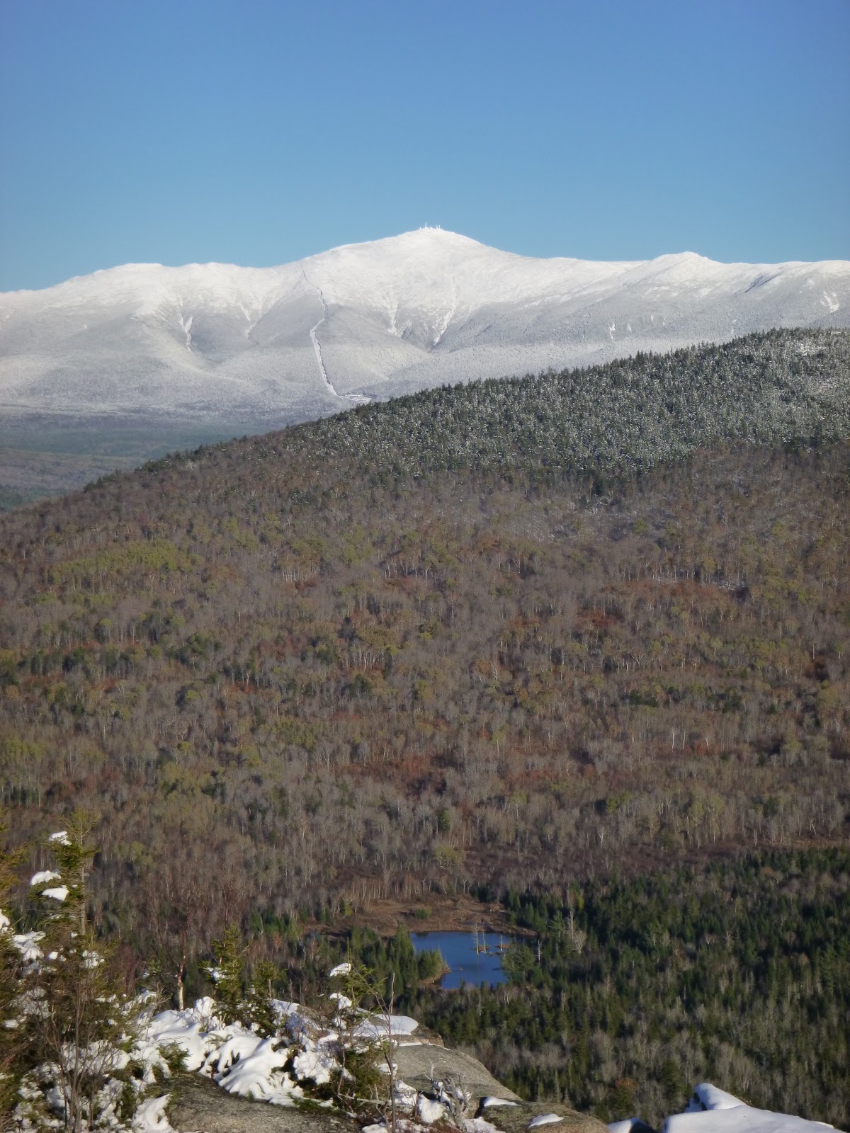

We returned to the trailhead not long before sunset and grabbed coffee at a gas station for the drive home, which took us through Franconia Notch at dusk, listening to nostalgic oldies on the radio – songs from the eighties and nineties that had been popular, it seemed, not so long ago, soundtracks to fleeting episodes from our pasts.

Notes:
We got to know Hutch and Shari over the summer when they worked with us at Old Quarry. They’ve spent most of the last six years living in a tiny ‘canned ham’ travel trailer, traveling all over and documenting their adventures on their blog, Freedom in a Can.


Info on these hikes can be found both in the AMC White Mountain Guide and in AMC’s Best Day Hikes in the White Mountains by Robert N. Buchsbaum.


Tuesday, October 16, 2018

Autumn Leaves on Mount Avalon


I’d been walking a short time, gazing down at my feet stepping through a golden-yellow layer of recently-dropped birch and aspen leaves, when it occurred to me that my pace was falling in step with the rhythm of a tune moving through my mind: Autumn Leaves. Aside from the obvious reference to my surroundings, the tune set a comfortable, relaxed pace, a good way to start a hike, and I didn’t mind. I seem especially prone to getting these ‘earworm’ tunes stuck in my head, following me for miles while I paddle or hike, and they’re not always so unobtrusive. Sometimes it’s the last tune on the radio en route to my adventure, but it may also be a recurring theme, like the instrumental disco anthem that followed me for much of the Maine coast on our Upwest & Downeast paddle last year. More and more it seems my earworm tunes lack lyrics, which I find agreeable enough, especially when this figment of my imagination drives the constant, multi-pitched ring of tinnitus, another made-up sound in my head, into submission.


I was headed up the Avalon Trail in Crawford Notch, which is a bit of a bargain hike to get to a view of the valley. But I was lured by the proximity of a couple of taller mountains, Mt Tom (4051’) and Mt Field (4340’) upon whose flanks Mt Avalon (3442’) is situated. Though I wasn’t expecting huge views from the taller summits, I was in the mood to walk, and it was a warm sunny day, probably the balmiest we’d see in October.


The tune cycled through my head, mostly drawing from the version I’d heard the most, from Cannonball Adderly and Miles Davis. I’d never known the song’s lyrics, but somehow the instrumental versions convey the bittersweet sense of longing and wistfulness at least as well as any words could. I don’t know how that works – that a simple tune seems to embody ideas and feelings without the help of spoken language, but it does. And since a melody is more universal than lyrics, it seems to apply itself to your surroundings more readily. The warm day made me more aware of its passing, wistful for all the summer days now past, and the leaves were probably as bright as they would be before the next storm knocked them down and the season rounded the corner toward winter.


I’d been in New Hampshire for about a week and I’d gone for a couple of other hikes as well. The first was not well-chosen for my first hike after a summer of paddling and little hiking. I headed up North Twin Mountain (4761’) with aims of getting over to South Twin (4902’) but I never quite got into it. It felt like a lot of work. My leg muscles burned with the uphill effort and I ended up with a headache (perhaps a bit dehydrated?) that took away from my enjoyment when I got to the summit of North Twin, which was socked-in by dense clouds. I finally remembered the ibuprofen in my first aid kit, which helped, but I had to admit I wasn’t really enjoying it, and headed down after a snack on North Twin.


For my next hike, I lowered my ambitions considerably, and had a gorgeous warm day. It was the Friday before Columbus Day weekend though, and the Kancamagus Highway was busy enough that I felt annoyed by the time I parked at the trailhead for Hedgehog Mountain (2532’). 


Despite the tailgating traffic that jammed all the scenic turn-offs, there were only six cars in the lot. I’d been to the trailhead before, and had one of those uncertain moments, unsure if I’d taken this hike before, but if I had, I’d forgotten it well enough, and it all seemed new and wonderful. You don’t have to go far before you step atop open ledges for expansive views of the 4000-foot mountains surrounding this little peak. I only ran into a few other people, but the trailhead lot was full when I returned, and I resolved to forego hiking until the weekend was over.


I did, however, drive to southern New Hampshire to buy a used canoe, and since I was in the neighborhood, thought I’d take a hike up Monadnock, a small mountain I’d climbed many times in my youth, when I lived in that area. As I approached the road into the state park though, I saw that it was closed off by the police – no room for more cars. They were doing me a favor, since such crowds would drive me nuts. Besides, I wanted to try the new canoe. In between hikes, I’d been out for a few short paddles, in kayak and canoe. They’ve been nice, but when I’m in New Hampshire I tend to think more about hiking.


The highlight of the Mt Avalon Hike was Mt Avalon, even if it doesn’t feel like much of a summit. There were also some enticing waterfalls, not far in from the trailhead. Mounts Tom and Field were fine, but you know you’re at the summits mostly due to the piles of rocks marking them, with limited views nearby. The top of Mt Avalon feels more like an open ledge on the side of Mt Field, but has by far the best vantage. A few other hikers came and went while I sat there, eating my sandwich, watching the cloud shadows pass over the brilliant patchwork colors in the notch. I could see our red car parked beside Route 302 down below, and not far away, the bright red roof of the Mount Washington Hotel. The summit of Mount Washington was shrouded in clouds, never revealing itself.


I overheard a couple counting the 4000-footer mountains they’d been up, and I suppose that personal challenge (much like the MITA 30-In-30 Challenge I’d embarked upon over the summer) brings a lot of hikers to these and other peaks that, while they offer some nice hiking, have underwhelming views for the effort involved. I joked with the couple that there was nothing wrong with the views; after all Mt Tom had a nice spruce tree with some lovely mosses surrounding its base, as cultivated as a terrarium. And of course there were those piles of rocks. Mt Field had a view of Mt Washington from a small opening in the trees.

When hiking to mountaintops I often remind myself that Thoreau wrote in his journal “… It is remarkable what haste the visitors make to get to the top of the mountain and then look away from it." It’s just a reminder that there’s more to a mountain than the view away from it, but it can also be a bit of a rationalization when you’ve just sweated to a mountaintop and there’s not a lot there that makes you want to linger. But Mt Avalon’s views were good enough to make me linger, and for just a little while forget the tune in my head.


Notes:
In addition to AMC’s White Mountain Guide, I’ve been using AMC’s Best Day Hikes in the White Mountains by Robert N. Buchsbaum. The book helps winnow the nearly endless hiking options in the White Mountains down to a few of the more attractive ones. In addition to the nuts and bolts info in the White Mountain Guide, there’s a bit of the author’s take on what it’s like to hike in these spots, why one would want to go up one trail instead of another, as well as historic background and natural history.


Wednesday, October 11, 2017

Two Hikes in the Southern Presidentials

-->

After hiking up Mount Washington, I wanted to get-out to some of those ridges and peaks that surround it. It seemed a good idea to follow the hike with something a little less challenging to let my legs recuperate, and Mounts Webster (3910’) and Jackson (4052’), at the southern end of the Presidentials seemed like a good plan. The two peaks can be hiked as a loop on the Webster-Jackson trail, with about 2400’ of elevation gain. The day felt unseasonably warm and sunny, and it felt great just driving to the trailhead, listening to music, drinking coffee.  The fall colors in the morning were not as brilliant as they would be for the return drive.

It had rained the night before and the air still felt moist, the rocks in the trail still damp and slippery, the ground dotted with bright red berries that had blown down from the treetops. I took a side trail to take-in the view at Bugle Cliff, and it occurred to me that I’d been here before, probably multiple times, and probably not all that long ago. I suppose I must gravitate toward easy loop hikes with a view. I was happy to hike it again, but perhaps wondering why I can look at a chart of the coast and pretty much imagine - in detail- every place I’ve been, while mountains seem to blend together in my memory. Maybe I just need to hike more often.


Not far below lay the AMC Highland Lodge beyond a stretch of still mostly green treetops with a few reds and yellows sprinkled-in. Farther off, the red roof of the Mount Washington Hotel looked like another splotch of fall color. There’d been a woman ahead of me on the trail, and I’d taken the cliff detour as much to give her some space as for the view… giving myself some space really. I wanted to be in my own world for awhile, and I was: no other hikers. It’s worth mentioning that this was mid-week.


I paused at a pool below a waterfall on Silver Cascade Brook, and the trail climbed gradually up to the white-blazed Webster Cliff Trail, and took a short detour to the summit of Webster. I found a spot out of the wind and ate a snack. There’s a great view of Crawford Notch and the mountains off to the west, but stunted trees obscure the view to the east. But this is also the beginning of the ridge that, with a few significant ups and downs, leads toward Mt Washington. For me, some of the thrill of hiking to these places is akin to exploring in a sea kayak: just taking-in the lay of the land, seeing the contours you’ve studied- now in 3-D. It is weirdly satisfying.


Atop the ridge, the path over to Mount Jackson feels pretty relaxed: a meander over bog and damp, mossy forest spanned by timber boardwalks. Like Webster, the top of Jackson is mostly forested, but a rocky outcrop affords expansive views of the ridge leading up to Washington, around which blew turbulent, swirling grey clouds. I sat and ate a sandwich with my map on my lap, identifying the bumps on the ridge: Pierce, Eisenhower, Monroe.


I hadn’t planned on continuing to Mt Pierce (4312’) but I felt good, the day was still young, and it just seemed a waste not to. It only added 2 or 3 miles and a bit of ascending. Plus, there’s something about walking on the AT that urges you onward, following those white blazes and the footsteps of so many before you. There are some pretty spots along this walk, damp, grassy bog-meadows that open-up in the trees, with the mountainous backdrop behind.


Pierce is partially forested like the previous summits, but just a little higher-up and a bit more open. As I began descending the Crawford Path I started running into a few hikers, including a loud-talking group that fell-in behind me, encouraging me to increase my pace, skipping down the trail with the help of my trekking poles, until I could no longer hear them. And I kept going.


On Saturday, I had a family dinner to get to in the early afternoon, so again I wanted a hike I might be able to finish quickly enough. Having been up Monroe and Washington and then the southern Presidentials, I felt drawn to the one peak right between them: Mount Eisenhower. And the Edmands Path, a 3.3-mile trail that ascends 2750 feet seemed a good choice. At 8 am, mine was probably the fifth or sixth car in the lot, and I passed only one pair of hikers - backpackers - en route to the top.

The Edmands Path is handy, and a relatively quick way up to the ridge over a not-too-bumpy trail, as well as a nice walk in the woods, but most of it is just that- a walk in the woods. As you ascend, occasional openings in the trees afford views over to the Cog Railway base and the flanks of Mt Monroe, but on Saturday even those views were soon obscured by clouds. At the ridge, I donned a couple more layers and headed-up the Eisenhower Loop, encountering very strong winds as I made my way up.


Approaching the summit, I remembered a photograph from my first hike here, which was in ninth grade- maybe 1978. The photograph was in the local newspaper, and accompanied my first ever trip report, which I co-wrote with my friend Noel, a Filipino exchange student whose vocabulary was much broader than my own, and included a few fancy words that I’d still have a hard time using in a casual sentence. Like, for instance, ‘scintillating.’ This was probably my first trip with a school program called ‘Project Exploration,’ and our victorious pose upon this mountaintop expressed what a big deal this was for us. Our shapes were jaunty, near-silhouettes against the cloudy backdrop, and I stood off to the side of the group, hefting a stout hickory walking stick, and a brimmed hat upon my head- gifts from my parents they must have hoped might encourage these outdoorsy pursuits I was lately into.


A single cairn marked the high spot, obvious as the summit only because the earth sloped away –off into the clouds- in all directions. A man hunched behind the cairn, and before he left, remarked that it was probably blowing forty. I stayed for a few minutes, watching as the clouds blew past, occasionally catching a brief tease of mountains beyond the clouds.


On my way down, I encountered other hikers- and soon even more other hikers. I stepped aside to let them pass (whatever the etiquette, they were working harder than I was, and I didn’t mind a brief breather to let them pass). Many asked how far it was and what the conditions were like, and after witnessing enough disappointment, I changed ‘windy and cloudy’ to ‘dramatic.’ It was a bit stunning really, how many people were coming up the path, and when I returned to the trailhead at about noon, the parking lot was overflowing, with cars parked on the roadside far in each direction. Even more stunning was the volume of parked cars and traffic in Franconia Notch. The colors were pretty, yes, but I think I’d look for a quieter spot if I encountered such congestion. I was glad I’d made an early enough start.

That’s it for New England for a bit. We’re now en route to Newfoundland, where I expect we’ll do some walking and paddling as well. It’s not as simple as it might sound, this uprooted lifestyle. We’ve just spent an evening and a day at Rebecca’s rented studio space (and our storage space) in Stonington, Maine, unpacking and repacking the car, trying to figure out what we might need for a journey of indefinite length – the art stuff, the kayaking and hiking stuff… and the cold weather stuff, should our stay extend beyond the fall. All this dealing with stuff just makes me appreciate even more those unburdened days that somehow feel stolen, in which I can get out and stretch my legs, and get to a place that makes it all feel worthwhile.

Friday, October 6, 2017

A Tale of Two Summits: Mount Washington and Katahdin

-->

A couple of days ago I walked up Mount Washington, New England’s highest peak. I’ve been trying to go somewhat easy on myself, looking for the longer, more gradual trails than the shorter, steeper ones, so I opted for the Ammonoosuc Ravine Trail, which follows the headwaters of the Ammonoosuc River as it cascades down from the saddle between Mount Monroe and Washington, where the Lakes of the Clouds Hut sits close enough to a couple of alpine ponds to appear to have the twin benefits of mountain access and waterfront property. 


It’s an awfully nice hike. Perhaps the frequent stops to admire waterfalls and pools made the hiking easier, keeping my pace moderate and my eyes open. In addition, we seemed to have been experiencing, by my count, our third Indian summer, and the air felt warm, and the sun shone as if it were a summer day.


As the ridge to the north became visible, I caught a glimpse of a bright, aqua-green rail car being pushed by a white engine on the Cog Railway, slowly ascending. It reminded me of my first (and probably last) hike up Mt Washington. I was in 7th or 8th grade in Massachusetts and a kindly teacher drove “The Outing Club”- probably 4 or 5 of us in all – in his VW microbus to hike up the Jewell Trail. We left when the train began its ascent, and arrived at the summit – I remember it was cool, clouded-in and blustery – just as the train arrived there. I doubt the summit that day was anything like the circus it can be, but it was enough of a glimpse that in the last 40 years or so, I’ve tended towards mountains that don’t have an auto road and a cog railway taking people to a mountaintop where they can eat in the cafeteria, shop for souvenirs and visit a museum and historical sites. For some reason today, those things didn’t hold me back.


I took a side trip up to Mt Monroe’s summit where I ate my first peanut butter and jelly sandwich, then continued back down to the hut (closed) and the lakes, where a group had hiked down from Washington’s summit and were posing for all manner of photos with the pond and hut behind them.

Mount Washington is obvious for miles around, not only for its height and massiveness (the mountain seems to encompass the surrounding high peaks) but also due to the various antennae and structures sprouting from its summit. Aside from taking away from the wildness of the place, the structures lend a utilitarian quality. I don’t know what all those apparatus accomplish, but they certainly look like they must be doing something important- weather instruments, whatever the observations made by the Mount Washington Observatory are. I began seeing a few people up there too, although from the trail it still felt fairly quiet until just short of the top, where, oddly, I encountered a younger couple hiking toward me, and my first thought was that all these Millenials are really starting to look the same. But then I saw that the guy recognized me as well, and remembered me as the guy who had rented kayaks to him and his buddies last week in Maine.


The wind had picked-up enough that I held my cap in my hands as I entered the summit area and encountered hordes and hordes of people. It doesn’t get much more touristy than this. Most had obviously either driven up or taken the train, and now wandered around, mostly looking for places to take pictures of themselves, hunched against the 35-mph winds. The summit sign had a long line leading to it. Thoreau wrote something to the effect that so many climb the mountain, only to look away from it, but now they get a ride to the summit and take pictures of themselves there.

Beside the summit building a long line of people, including a bunch of Amish, the men in flat-brimmed straw hats, waited for the trains to arrive. I joined others taking photos of the engines pushing the brightly-colored cars up the last incline. Nearby, a man in a cap with big NRA letters on front (this was two days after the Las Vegas shooting, and I had to wonder if he always made this statement) stood chatting with a man in a veterans hat, loudly talking about World War II  (no, they weren’t old enough to remember it so fondly). It took some effort to push my way through the crowd so I could get into the summit building, and I remembered why I prefer most of my mountain hikes to culminate at an undeveloped summit.


I went into the summit building, bought a coffee at the cafeteria and sat down for my second PB&J. It felt a bit like a food court at an Interstate rest area, or like a ski lodge where everyone has come in out of the elements to show off designer ski clothing, except that when you glance out the windows you look out at clouds just barely higher. It felt dark and noisy and stuffy, but the coffee was good and I was out of the wind. I sat and wrote a few notes and then finished my coffee quickly so I could leave.

I continued north on the AT, turning-off to descend the mountain via the Jewell Trail.


A week earlier, I’d hiked up Katahdin, Maine’s highest mountain and the terminus of the Appalachian Trail. It was a wonderful hike, worthy of more words than I’m giving it here, but the contrasts between the two mountains are worth noting. It was my first time up Katahdin, and I’d grown a little weary of admitting that no, I hadn’t hiked up it- summers and fall had been work-time for me since I’d lived in Maine. But now that we took summers off, essentially taking a vow of poverty and more free time, here I was. It also helped that our friend Susan made the parking reservations and put us up in a hostel in Millinocket the night before.


Katahdin is in Baxter State Park, which according to the wishes of Percival Baxter, the Maine governor who created the park with his own funds and wherewithal, has a few bureaucratic hoops for us to jump through to ensure the park retains its wild nature. It would be easy to whine about having to make parking reservations, or arriving before 7 am to either claim your spot or lose it. And thru-hikers on the Appalachian Trail need to secure permits to hike up Katahdin – and the park limits the number of permits it will issue.


Susan and I hiked up the Hunt Trail, the final 5.2 miles of the Appalachian Trail, and met a few thru-hikers as we walked, which leant a particular feeling to our hike, sharing in a momentous event for people who had imagined this day for months. 


Arrival at the summit is akin to reaching the destination of a pilgrimage. Some arrive at the iconic sign in tears. Some kiss the sign or place their forehead to it for a moment of silent meditation. Some can’t contain themselves and cry-out in joy. Everyone poses for a photo with the sign, often in configurations that have been considered for months. Everyone who arrives at this peak has put some effort into it, and there’s a feeling of camaraderie… of sharing this amazing holy place with a variety of other hikers, who may be diverse, but at least share something- they’ve all taken the trouble to get here under their own steam. People were generally quiet and respectful of each other, quick to share the experience somehow – by handing-off a camera for a snapshot, or saying ‘congratulations,’ or just quietly smiling at one another. 


Both summits are something other than just the top of a mountain. They each have cultural implications- which is to say that you get to observe some human aspect of the place. Each is interesting in its own way, and worth experiencing. And its not lost on me that there’s something good in the fact that people who might never otherwise experience a mountaintop can get out of a car or a train at the top of Mount Washington. It has been a tourist icon for maybe a century and a half, and that in itself is interesting. It is what it is. But I am so grateful that Katahdin is undeveloped. Somehow, that experience from Katahdin stays with me a little more than the one atop Mount Washington; in fact it makes it easier for me to shrug-off whatever negative feelings I might have about tourist hordes atop a place that will never again feel so special and say ‘it is what it is,’ just knowing that places like Katahdin still exist.

Notes: 
You may have noticed that this blog post does not involve sea kayaking or Stonington. Yup.

These routes occur nowhere in my guidebook AMC's Best Sea Kayaking in New England.

Sunday, June 28, 2015

Webb Cove in the Rain

Here we are again, finally, in Stonington. It’s a grey, rainy day, temperature in the mid-fifties, wind picking-up: a day much like some we had in Georgia in January. It’s not an inviting day to get out paddling, but my eyes keep wandering out over Webb Cove and I know how invigorating it would feel: the chilly water and wind, the waves bashing against granite. My mind wants to go, but my body says otherwise.


We arrived here at Old Quarry last night and moved the contents of our car into the apartment above the office. We’ve been making coffee and figuring out where stuff goes, looking outside thinking “should we paddle?” But I’m feeling worn-out, my limbs heavy and sore, a blister on my big toe still subsiding. It’s from the last week of play, and perhaps the last month of travel catching-up. We’ve been on a lake in New Hampshire, a family place where I haven’t spent much warm-weather time over the last dozen years. I was glad to be at the lake, and though it’s a nice place to paddle a kayak (and we did most days) I felt more inclined to hike in the mountains or try my newly-learned canoe-poling skills.


Actually, I spent more time there gardening, trimming brush on the point where, 25 years ago this August, Rebecca and I were married. I spent hours with loppers and shears, sometimes while standing in the water, trimming the undergrowth that was crowding-out the twisting mountain laurel with its snowy bunches of flowers. I’d tell myself I’d just cut away a few branches, and my focus would narrow into a meditative state: clip, clip clip, and onto the next. Hours would pass and I’d look out at the lake and the mountains and think “gee, I should go paddling.” Then I’d start trimming again. I guess, deep down, I’ve got some need to take care of a piece of ground. We felt it in Georgia, where I mowed the first lawn we’d had in 17 years, but resisted most urges to get into long-term landscaping. Rebecca and I have moved around a lot, but the point is the one piece of ground that we keep returning to.


But on Thursday I went hiking. I chose the Skookumchuck Trail trail because it ascends the 3000-plus feet to Mt Lafayette’s summit in 4.7 miles, rather than the more popular, but steeper trails that make the climb in a shorter distance. I wasn’t on top of my walking routine, and I’d hardly even walked up any hills since last fall. I imagined an easier walk, but in the first ten minutes of my hike, I knew that the summit, should I get there, would be hard-won. So I tried to slow down, pausing by the brook to take pictures of flowers. There was no one else on the trail.


I have hiked up Mt Lafayette many times since I was ten or eleven years old. The sixth-highest of New Hampshire’s White Mountains, Lafayette is the high point of the Franconia Ridge, a spectacular stretch of alpine tundra that drops steeply away to valleys on either side. Aside from the more gradual grade, the Skookumchuck Trail offers a less populated walk; only one other car was parked at the trailhead. After about three hours of quiet, solitary walking, I encountered the other hiker- a man a bit older than me who’d paused at timberline. We chatted for awhile and then I continued onto the ridge.


Lafayette’s summit was crowded. I ate my lunch, watching hikers arrive and pose for photos. I obliged a French-speaking couple who wanted pictures of themselves, but didn’t ask for the favor in return, thinking I didn’t need another shot of me on a mountaintop. Then I thought better of it and felt strangely self-indulgent and vain when I snapped a couple of selfies. After all, who knows when I might get there again?


The part I’m leaving out- and my excuse for including this story in the blog, is the pain. Going up that hill was hard work, and several painful spots had developed well before I reached the top. For the trip down, I used my trekking poles to reduce the impact on my knees, but a hot spot on my big toe officially turned to a blister that I felt with every step. It felt great to jump in the lake when I returned, but I knew I’d be feeling the hike for several days.


Add poling a canoe to the list, and it helps me, as I sit here looking out at the rain on Webb Cove, to inventory the various aches and pains. And it also helps me appreciate the efficiency of sea kayaking, perhaps explaining why it is a popular sport for so many of us who are realizing, bit by bit, that we’re not getting any younger.