Showing posts with label Deer Isle / Stonington / Isle au Haut. Show all posts

Friday, March 5, 2021

Gooseberry Island


As we paddled along Little McGlathery Island, a mild swell washed over the near-shore rocks, lifting our kayaks gently and then dropping them as the waves rebounded from the granite bluffs.
 Gooseberry Island lay to the south, with Isle au Haut rising behind it. The day had started bright and clear, but now a layer of high, wispy stratus clouds floated over us from the west, the sun a pale disc. Rebecca maneuvered beside me. She said, “Lunch on Gooseberry?” We turned our bows southward. 


Paddling excursions had lately been the result of watching the weather, and days ahead, deciding that a particular day might be good enough for a paddle. And when that day arrived, if the weather forecast was close enough, and if we weren’t too lazy or too stuck in our routines, we dropped everything and went. Sunday was one of those days. With the temperatures approaching 40 degrees, we made some sandwiches, filled the Thermos with hot mocha and went for a paddle. We had a few ideas about places to go, but once we launched we just pointed across the Thorofare and went with no particular goal, until finally we found ourselves on the seaward side of Little McGlathery, angling out toward Gooseberry Island, a half-mile off. 


Even on the last day in February, I had a sense of relief as we rounded the point and saw that there was no one else at the beach where we liked to land, at the head of a narrow cove, overlooked by a dense boulder field. Of course, there was no one there, but the habits from summer remain. We hadn’t come across other paddlers since some time in the fall, and in a way I looked forward to seeing others out there again. There weren’t even many lobster boats out, quiet for such a nice day. 


We landed on the shell sand beach, barely pulling our boats up since the tide was retreating, and we sat on a log to eat our sandwiches. The water looked glassy clear, as it does in winter when there’s less algae, but frigid, probably just above freezing. I don’t think we had much to say. We’d had no shortage of time together lately, and we always found things to talk about. But it was also a relief just to sit and eat our sandwiches and look out toward Isle a Haut, with the clouds thickening before the sun. 


We then walked out among the boulders. I can’t think of any other spots with such a concentration of them, like the glacier just tired of artfully placing them here and there on sloping granite shores and said “ah hell, just drop ‘em all here.” Walking among them feels like strolling through a natural sculpture garden. 


Gooseberry Island is one of the many names that pops into my head when someone asks me about a favorite place out in the archipelago. It’s been a favorite for a long time, even back when it was privately owned and we’d heard that Maine Coast Heritage Trust would acquire it. We like the island’s small size, the boulder field, the way it feels like the last stop at the edge of the archipelago, with Jericho Bay and Isle au Haut for a backyard and the vast Atlantic stretching out beyond. It’s only about 3 ½ miles from the launch, a good distance for a casual paddle, just far enough away from the busier islands near town, and yet angled away from the archipelago, so it feels more remote. 


We started feeling a little chilled and launched again. I made my inevitable joke about skipping the swim at Green Island, and when we returned to the launch we were surprised how late it was; the days were getting longer. 

Friday, January 8, 2021

The Fort, Second & Andrews Islands


Our winter excursions tend to be a bit less ambitious than in warmer months, so if we launch from town, we find ourselves at the usual places fairly often. Nothing wrong with that, but I couldn’t remember the last time I’d paddled out the Deer Isle Thorofare and, instead of going left or straight, taken a right turn.


With all the attention given to the islands between Stonington and Isle au Haut, some nearby neighborhoods are often overlooked, like the southwest corner of Deer isle with its trio of small uninhabited islands just offshore. It really does feel a bit like a watery neighborhood, bounded on the north by Fifield Point, which stretches slightly southwest toward The Fort and Second Island and more distant Andrews Island. The stretch of residential shoreline between Fifield Point, Sand Beach and Moose Island makes up the other side – about a mile-and-a-half of bulbous, glacially smoothed granite with a few pocket beaches and a bunch of (mostly) modest summer cabins.


Rebecca and I met Todd down at the ramp just after lunch and headed out just as the tide was cresting. The clouds were thick and gauzy, with the sun occasionally shining through. Temperatures hovered around freezing; we were comfortable as long as we kept moving.


We went past the boatyard and followed the shore of Moose Island, past the newer, large homes with corresponding ‘PRIVATE ESTATE’ signs posted over the beaches. With the tide so high, there were plenty of shoreside rocks to weave among, and a very slight swell rolling in, and as often happens in such conditions, we started focusing less on any destination and more upon the feeling of maneuvering through these passages. 


The sun was already low, dimmed by clouds, casting the boulders in  a flat, wintery light. We paused and remarked that none of us had harbored high expectations for this developed shoreline. Perhaps in the summer, with more people around it would feel busier, and certainly at a lower tide we would be more limited in our options, but at high tide on a winter’s day, when many of the summer cottages had boards over their windows, surprise, surprise: it was pretty nice to be there. 


Sand Beach, which is essentially a town park and a go-to spot for those wanting to get out for a bit of fresh, salty air, or perhaps a sunset over the Camden Hills, was empty. We followed the shore and finally spotted a distant couple walking the shore, pointing binoculars out toward the water.


At Fifield Point we headed across to The Fort, a 2 or 3-acre island with a prominent rocky bluff rising above many of the trees. The island is only a couple-hundred yards from the point, but we began to feel the northeast breeze as we pulled away from shore – the wind from the northeast was part of our logic in choosing this mostly sheltered route – and we felt quickly chilled as soon as we landed. It would need to be a quick stop. Maine Coast Heritage Trust owns the island, named, apparently, as a reference to a time in the past when it was a popular duck hunting spot, and often resounded with gunfire. A trail leads up to the high point atop a granite promontory with broad views of East Penobscot Bay. It’s a big view for so little effort. Across the bay, the Camden Hills were spotted with snow. Nearby, in the shallows leading toward Second Island, seals were piled upon a ledge. 


I’d be lying if I denied repeating our usual winter mantra: this would be really nice in the summer. It’s fine out there in winter, and certainly better than not paddling, but right now it sounds pretty idyllic to spend a little more time hanging out without getting cold. We paddled around Second Island and over to Andrews, also owned by Maine Coast Heritage Trust and would have loved to have landed there and taken a walk around, but we were a little chilled and sunset was nigh. We paddled back to Moose Island and retraced our path back up the Thorofare, arriving at the ramp a little after sunset.


Notes: 

The Fort and Andrews Island are owned by Maine Coast Heritage Trust and open to day use. 


State-owned Weir Island, just off Sand Beach is on the Maine Island Trail and has a campsite.


Sand Beach is private land designated as a town park. In recent years it has suffered from a dramatic increase in visitation. The recently expanded parking area continues to become overrun, resulting in sloppy parking along the road. This past summer there were complaints, echoed in a newspaper story, about boaters parking trailers  that take multiple spaces. 


Sunday, June 21, 2020

Island Clean-Up


Although we’ve organized many annual island clean-ups over the years, usually to Wreck and Round Islands, this year it was not on our radar until the Maine Island Trail Association contacted us about their plans, which were a bit different this year. Because of the need for social distancing, it is problematic to put a bunch of diverse people together in a small boat, so MITA has asked people to volunteer for less organized efforts with fewer people. Of course, we could pick-up all kinds of trash out there, but can’t really get most of it back in our kayaks. 


MITA organized a concentrated effort off Stonington though, with the MITA skiffs picking-up garbage, so I sent out an email or two. Also, staff from Island Heritage Trust wanted to take part, so we took-on our usual Wreck and Round Islands, which are both owned by IHT and are on the Maine Island Trail for day use. 


We ended-up with a nice group of people: 9 in kayaks and another 2 in a skiff. Some local, some from afar (one from out of state who had done his quarantine time). Social distancing was not difficult, and I think everyone was happy to be part of a group with a common goal. Rebecca and I are pretty familiar with Wreck Island and where the garbage usually accumulates, and I think our methods have become more efficient over the years. We split-up and went opposite directions, finally meeting at a beach on the south side for lunch, joined by the two MITA skiffs and the skiff from our group.  And yes, we all kept our distance from each other. Note: in the next photo, the people sitting close to each other are in the same family. 


The forecast had been for some fog, so I was relieved that we had a clear day, even a bit hot (90s inland). The day was really just perfect in many ways- the weather, the paddling, the people. After lunch we went-on to Round Island and found part of it clean, obviously recently picked-up by an anonymous volunteer (thanks, whoever you are). The other side had the usual accumulation of fishing-related garbage.  We meandered back to town, stopping at Little Camp Island for the slightly elevated glimpse of the nearby islands from the bare top of the island, where wildflowers are starting to bloom. 


I hesitate to include the weird encounter we had there, which cast a little shadow over an otherwise perfect day, but it’s probably worth mentioning. As we approached the landing beach on Little Camp we saw a portable latrine tent set-up atop the beach. I don’t think I’ve ever seen that before, certainly not on a no-camping island, and I suppose it might have signaled an unusual encounter to follow (or it could signal someone really concerned about Leave No Trace visitation). There was a familiar local skiff anchored, and after we landed we noticed a beach blanket and assorted other stuff, but saw no people. 


We encountered the couple and their dog as we walked toward the height of the island. Just to summarize- and I missed most of the exchange, being hard-of-hearing and having walked ahead- but he complained that they’d come out there to get away from people and that there was a virus going on, etcetera. He was reminded it was a public island, which only drew a lot of angry swearing. We could have elaborated that not only was it a public island, but a very popular one, close to town, and not a place one should ever expect to have all to oneself. And of course we were only visiting for a few minutes near the end of the day. Fortunately it ended there. I watched over our boats as they packed up and left. It’s not worth dwelling on it, but it was perhaps a reminder of the strange time we’re experiencing. I’ve had very few negative experiences with people out there, and the current state of things seems to increase tensions, and perhaps also enhance local residents’ sense of territoriality and animosity towards people who might be from somewhere else (even though many local locals are of the ‘no mask’ ilk). Maybe it’s good to take it as a reminder to not make assumptions and to try to be nice. 

We returned to the launch, having left two islands in a much cleaner state, part of a bigger effort that improved a bunch of islands out there, and that felt pretty good. I would encourage anyone to look for these clean-up opportunities and get involved. Here's a link to MITA's 'A Call To Oars' announcement.


Notes:

1)    More info about this paddling locale may be found in my guidebook AMC’s Best Sea Kayaking in New England.  I get asked quite a lot for basic advice: what boat to buy, am I being safe, etc. There’s a lot of that in my book. Please buy it or check it out from the library. I don’t mind occasional requests for help or advice, but it does get old when people are averse to just reading a book where all these questions are already answered. 


2)    While the quarantine order for people coming from out of state is in effect, those coming from New Hampshire and Vermont are now excluded from the requirement, and all others may skip the quarantine if they have a certificate of compliance from a recent negative test. New inquiries and bookings have begun again. Yesterday’s trip gave me hope that we can be safe and socially distanced without it interfering with our on-water safety and fun.


3)    The new book: it’s getting there. I will probably make a Kindle version available before the print edition is out. Proofs of the print edition have taken much longer than expected, and we still have some illustrations to add. Also, Zest Maine will include a link to the Kindle edition in their July/August online issue, which posts on July 15. 


4)    One thing we’re offering this summer is a 5-week subscription series: 5 full-day trips with instruction in various locales for only $400 (that’s $80 per day). I’m not very good at selling myself. I meet and communicate with so many people who would benefit and something keeps me from pushing it. You can try out different boats before you buy one. You can learn things and gain some basic understanding of how to be safe, all while going different places on fun trips. And you can meet some other local paddlers. 


5)    Old Quarry Ocean Adventures is open again, with, for now, a pared-down selection of offerings. There will be camping and kayaking. You can go there to park and launch. The other day we met Eric, the new manager, and he’s got a great attitude. 

Sunday, October 6, 2019

Isle au Haut - Camping at Duck Harbor


As with our canoe trip the previous week, we were dragging our feet about getting out to Isle au Haut. I’d made the reservation for Duck Harbor Campground back in early April, which is pretty much the only way to get a reservation for the five-site, National Park campground. As the only public camping area on Isle au Haut, its sites are in high demand. The sites are deluxe – perhaps what some would call ‘glamping’ if you rigged-up a few string lights. Each site has a three-sided shelter, a picnic table and fire ring. There’s a couple of outhouses, and drinking water comes from a well just down the trail. It’s the perfect base camp if you’d like to spend a day or two exploring the rugged and remote southern end of Isle au Haut, either by paddling or on foot. 


If you’re just tuning-in, Isle au Haut is the big island (about 6 miles long and 2 miles wide) that lies 5 or 6 miles south of Stonington, our home on the Maine coast. Much of the island is part of Acadia National Park, but unlike the heavily-populated part of the park on Mount Desert Island, which is thick with tour busses and very casual visitors, access to Isle au Haut is by boat only, which has a way of weeding-out the riff-raff. It takes a little effort to get out there. 

Of course, as the big island on the horizon, it also has a way of attracting people who don’t know what they’re getting into. A decade or so ago, Outside magazine ran a short, rather misleading piece touting the island’s merits, suggesting that novice paddlers ought to rent a kayak and just head-out to the island, flagging-down a lobster boat along the way to grab dinner, and then “crash” in one of the lean-to shelters. For a while at Old Quarry, the ‘kook’ factor, already high, greatly increased. I still encounter paddlers whose plan is simply “Isle au Haut,” never mind the archipelago along the way, or the fact that much of the shoreline there is private or difficult to access. (Or the fact that paddling skills, including navigation might come-in handy). There’s a tiny village near the island’s north end, home to about 40 year-round residents and more in the summer.


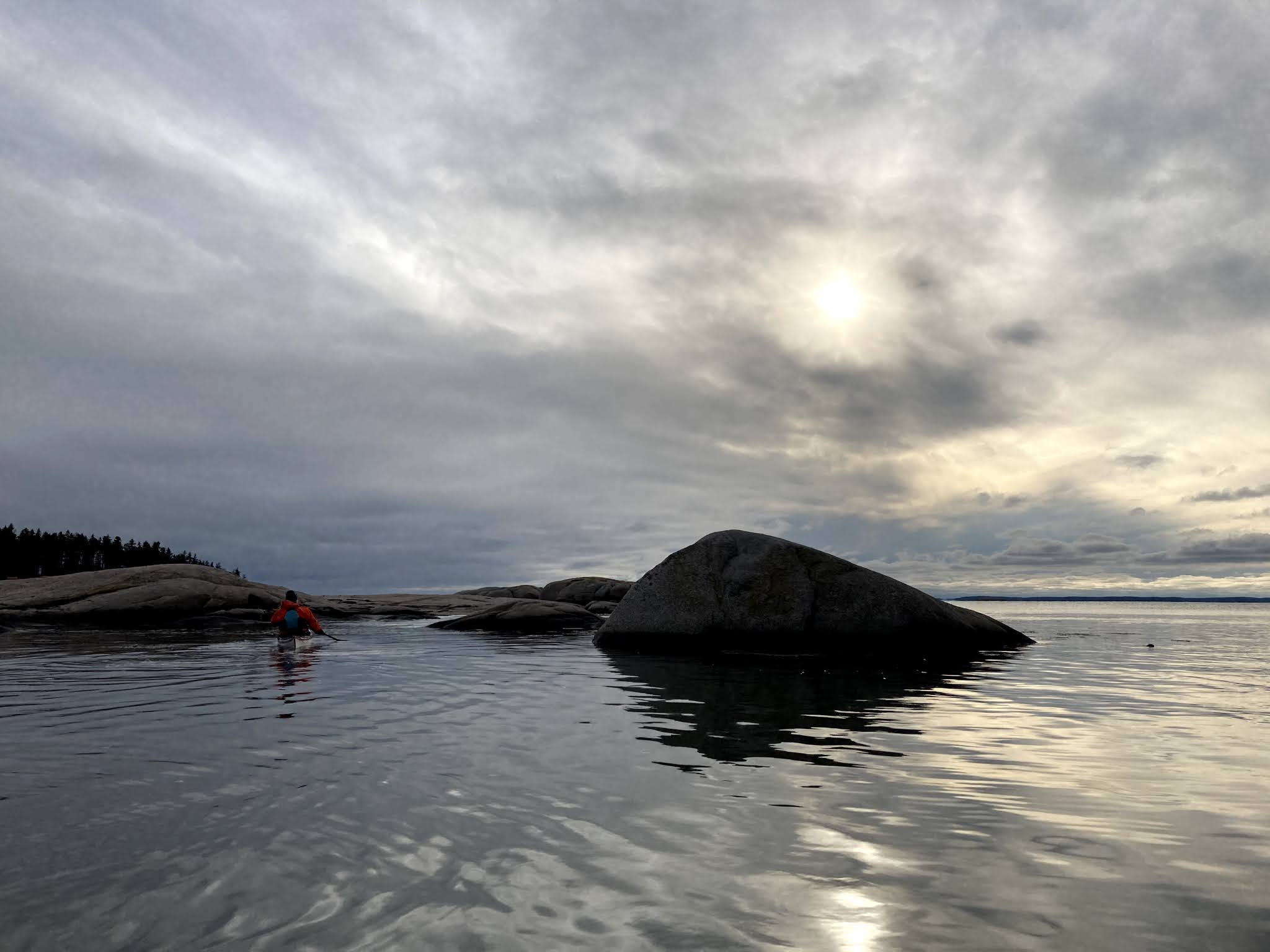
As is often the case for us, getting out the door took more effort than it should have, and we didn’t launch until sometime in the afternoon. We had the current and a north wind helping us along, but if we’d continued to Duck Harbor we would have arrived around sunset. 


After 45 minutes of paddling, we paused below the campsite on Harbor Island, eyeing the sun sinking toward the Camden Hills, and decided to spend our first night there. We had the maximum 3-night reservation at Duck Harbor, but as much as we wanted to get there and wake the next morning to a full day, we prefer to avoid late-day arrivals, especially when the seas are lively, as they were even in Merchant Row. So we camped on Harbor the first night.


The northern campsite on Harbor is a favorite (although I suspect I might say the same of any island in the archipelago when I happen to be camping on it). The granite ledge slopes gradually down to the water, where a cushion of rockweed makes it easy to pull a kayak ashore. We pitched our tent on the soil just above the ledge. I quickly set-up the stove on a particularly flat-topped boulder to cook dinner, and Rebecca remarked that I seemed to have the routine worked-out. I’d camped there a few weeks earlier with a client and used the same rock, and had probably used it in the past as well. There were a few mosquitoes, but we carried our dinner to a windier, bug-free outcrop and watched the sunset. By bedtime (pretty early these days) the wind further shifted northward, and it rustled our tent fly all night.


By Monday morning, we’d lost our previous sense of hurry and took our time leaving Harbor Island and then meandering out through the Isle au Haut Thorofare, past Robinson Point Lighthouse, and then the last couple of miles to Duck Harbor. 


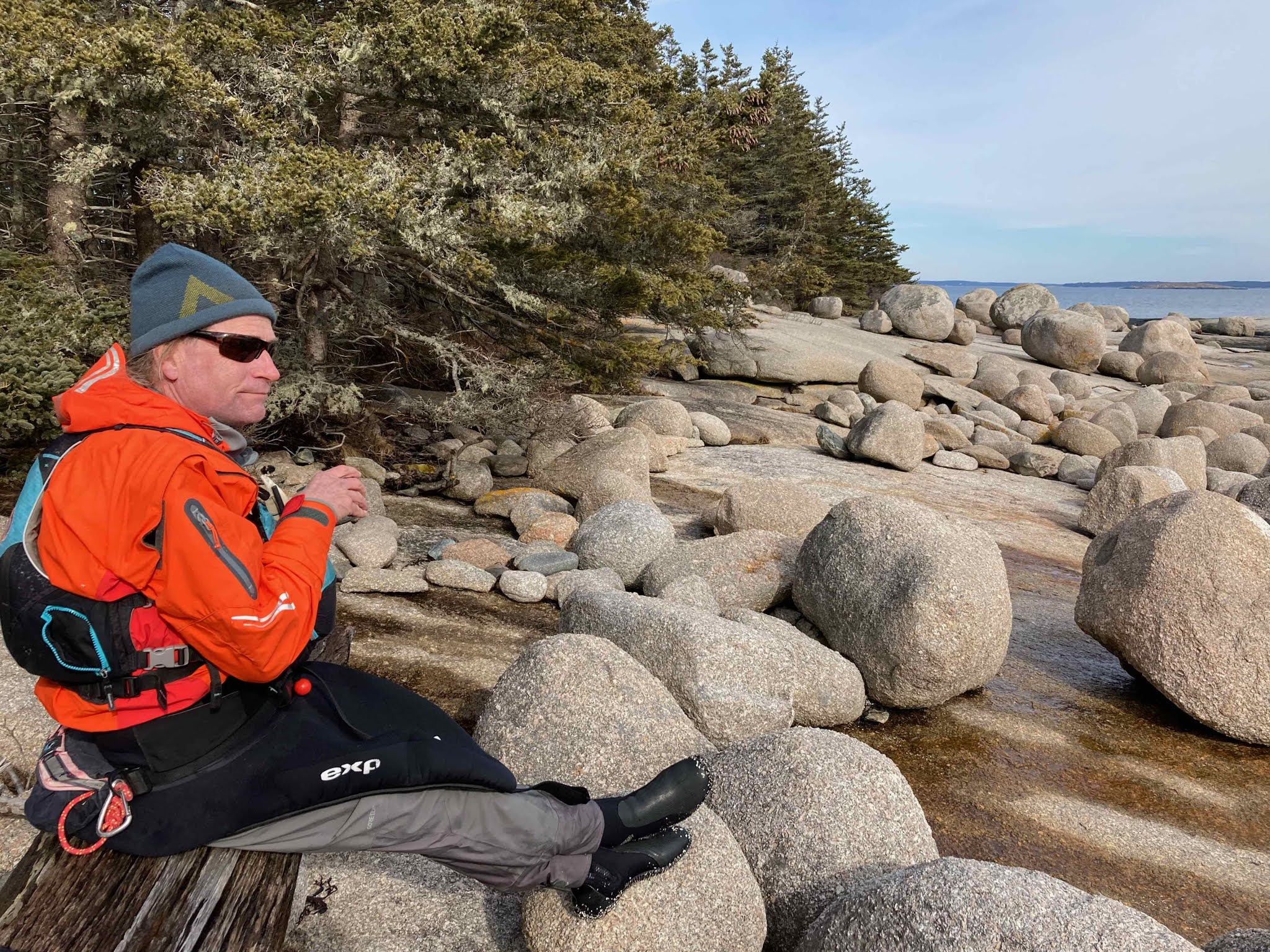
We parked our boats by the trail and carried our gear in Ikea bags up to Site #5. Only two other sites were occupied – perhaps thanks to the cool, windy weather and a rainy forecast. We’d stayed in the other sites, and this was our first time in this one, which is set-apart from the others, a little more remote, adjacent to a trail leading out to a cobble beach. We ate a late lunch and took a couple of walks, finally watching the sun begin to sink from the rounded granite hump of Ebens Head.


The first time we camped at Duck Harbor, years ago, we thought we’d use it as a kayaking basecamp. One could do that, especially if you wanted to don a helmet and get into the extensive rocks and ledges along the island’s southern end. But lately we had paddled enough that the simplicity of walking seemed a luxurious indulgence. Plus, you get to wear dry clothes. We headed-out around Western Head, pausing frequently to take pictures and just sit and take it in. 


It was nearing high tide when we arrived at Western Ear, the small island barred to Western Head at the southern end. Meaty waves rolled-in from the southeast, colliding over the bar with smaller ones from the west. We watched as the tide rose, mesmerized, regretting a little that we weren’t in our kayaks – I’d never seen such waves at this spot. Usually when I paddled around Isle au Haut I was out here around low tide. But this was a day to sit on shore and watch, which became more obvious as we walked the Cliff Trail. 


At every spot where the trail poked-out for a view of the waves crashing against the rocks below, we had to stop and take it in. 


We ate all our snacks. A walk that might take 2 or 3 hours grew into a 5 or 6-hour hike. We encountered no other hikers that day, and the only boats we saw were a couple of lobster boats.


The winds that day, Tuesday, were from the south, and would have made our paddle back to Stonington easier than in the strong north winds predicted for Wednesday. But by the time we arrived back in camp for a late lunch we were tired and didn’t feel like packing-up and paddling. Besides, reservations out at Duck Harbor are hard to come by, and you might as well make the most of them. 


We spent one more night and paddled back amid lively seas Wednesday morning, into a powerful headwind: exhausting paddling. It really was a mistake to not head back a day earlier, when the wind was in our favor, but it allowed us another long, leisurely day out there. And now with the hard work behind us, when we’re no longer cold and wet, it’s easy to only remember the more enjoyable parts.


Every time we go out to Western Head, we’re struck by what a different world it is from Deer Isle, and yet so close. Every time we go, we resolve to get out there more often. A few weeks ago we paddled out in the tandem in a little over two hours – maybe that’s one way we can do it. Or we just need to work less and play more.

Notes:
Read more about this route in my book, AMC’s Best Sea Kayaking in New England.

Reservations for Duck Harbor Campground may be made starting on April 1st. I suggest you wait a few days though, until we have our reservation.

Wednesday, October 3, 2018

The Last Five


Parked beside the road at Reach Beach, I took my kayak down from the car, and placed it on the sand, just a dozen or so feet away, where the water lapped at the bow. It was nearly high tide on a placid mid-afternoon, the last day of September, with three or four hours before dark, and I had a goal: to land on the five Maine Island Trail islands at the east end of Eggemoggin Reach. To get to them I’d need to paddle a loop of about ten miles and not dilly-dally too much along the way. I loaded my boat and headed out.

It had been at least a week since I’d last paddled, and I could tell; it felt like work. Maybe it was that I was so focused, paddling faster than usual, thinking about how I barely had enough time to cover the route before sunset, but how I really wanted to get to these islands. These would be the final five islands I needed to land on to meet the Maine Island Trail Association’s 30 in 30 Challenge. The deadline was still a week away, but we would be heading to New Hampshire for a bit, so if I wanted to meet the challenge, this was my chance. 

Campbell Island, #27
If you’re just tuning-in, the 30 in 30 challenge is MITA’s way to celebrate the Trail’s 30th year, offering a rare, special edition piece of headwear for those who land on 30 islands before Columbus Day. All you have to do was set foot on the island and then document it. Man, I really wanted that hat. (Of course, what they’ve failed to mention is that the hat is what some would call a lampshade with the number “30” scrawled on it with Magic Marker). It was rare for me to have such a goal. Most of my personal, non-work paddling this year had been fairly leisurely, mostly to get away from it all, in pursuit of hammock time as much as exercise. I’d become a bit of a slacker.


The mountains of Mount Desert Island rose to the east, beyond Blue Hill Bay, their peaks cloaked in a low layer of cumulus, but here it was absolutely clear and sunny, a crisp autumn day with a mild breeze. A couple of small sailboats crisscrossed Greenlaw Cove. I weaved among near-shore rocks below the houses on Oak Point. I realized I was still thinking of the goal more than enjoying the moment, maybe not enjoying it as much as I could, but whatever – I had places to be. Ahead, at the mouth of Fish Creek lay Apple Island, and I thought ‘that will be number 26.’ I looked over at Campbell Island, off to my left and thought ’27.’ I looked at my watch. 

Sheep -Stinson Neck #28
But then, up ahead, a seal popped its head above the surface and looked at me. The water near it roiled with movement, and I steered toward it, arriving amid a school of densely swarming foot-long fish. They swam beneath and turned, as if of one mind, like a cloud moving through the water, catching silvery flashes of sunlight. The cloud moved to the surface, breaking through with fins and tails, a mob of fish, and circled around. This was unusual. If I saw fish around here, which didn’t happen often, they were usually finger-sized, corralled into shallow coves by terns. These were big, fat fish, thousands of them, and I sat floating for a while, watching. I thought vaguely of my schedule, my need to get to five islands before dark. And I lingered a bit longer – so what if I came back in the dark? If need be, I had lights. 

Sellers Island, #29
I continued toward Apple Island, perhaps a bit slower-paced than before. But I felt more ‘there.’ Maybe then I felt some of the stress of the last week begin to slip away. As our season at Old Quarry wound-down, we got the news that we needed to move out of the space in Stonington where most of our belongings were stored, and Rebecca would need to find a new studio. We’ve been transient for nearly four years now since we moved out of our gallery and apartment in downtown Stonington, and we’ve lived either in outfitter housing or in house-sits, but this approach was only possible because we’ve lived with a tiny fraction of our belongings, the furniture and most other household items stored away. So for more than a week we’d been moving from one storage unit to another – an exercise in futility if there ever was one – and to a new studio space for Rebecca.


I arrived at Apple Island and walked around, looking for a photo to document my brief visit. It can be tough to find something interesting when you only hop out of your boat for a few minutes. I felt hungry, but I didn’t have any snacks – I usually paddled with granola bars stashed away in various pockets, but this time I had none. But there were apples on the trees. The lowest had been eaten by deer, but I found a stick and knocked one from a higher branch, and it tasted perfect: sweet, crisp, as fresh as it gets. So I knocked down a few more and stashed them in my day hatch.

Apple Island, #26

I went on to Campbell Island (27) and Sheep Island - Stinson Neck (28) and then headed across the Reach, where I landed on Sellers (29) and finally Little Hog (30). Somewhere in there I found my rhythm and the paddle strokes came more naturally, with less effort. Then, with the current against me, I stayed on the Brooklin side of the Reach, skirting the edges of Babson and Little Babson Island to where I could paddle against a little less of the flow to cross back to Deer Isle. The sun was sinking in the west – right over Grays Cove. I pointed my bow below it and headed back.

Little Hog Island, #30


Notes:
There’s still a few days to take part in MITA’s 30-in-30 Challenge. You too could wear one of these hats.

In mid-September, I paddled a tandem with Joseph Rosendo, host of the PBS series Joseph Rosendo’s Travelscope. We were followed by a film crew in the NIGH DUCK who recorded our conversations, including a stop on Hells Half Acre, where I had a lot to say about the merits of the Maine Island Trail. The episode will air sometime later next year.

This wasn't our year for doing big kayak trips, but we were able to enjoy the trips of others vicariously, and sometimes offer a little assistance. Cheri Perry and Turner Wilson, who together travel the world teaching, mostly Greenland skills, under the auspices of Kayakways, came through Stonington on their way downeast on a long coastal trip, and we just saw them a few days ago while they were driving home. I saw bits and pieces about their trip on Facebook, and hope someday to hear more about it.

In addition to moving stuff between storage units and studios, we've moved from Old Quarry into a an apartment we'll be sitting until next summer. It overlooks Stonington Harbor and is a short distance from the launch there.


-->

Saturday, September 1, 2018

Lunch on Kimball, Hammocking on Gooseberry


I had an unexpected day off, and since it was raining and a bit dreary, it seemed unlikely we’d be getting overrun with visitors at the campground. I packed my boat and headed out mid-morning in the pouring rain. The air felt warm though, the raindrops invigorating, and with a day ahead of me, I could meander at will, maybe even find a little time to relax somewhere if the weather cleared.


There were a few MITA islands in the archipelago that I hadn’t visited since I started the #mita30in30 challenge, Little George Head, Harbor and Kimball, so I paddled off in that general direction and saw this pretty boat as I crossed the Thorofare.


As I rounded Green Island, the cove was completely empty – no boats tied-up at the landing, no kayaks on the shore – so I thought ‘why not?’ and stopped for a quick swim in the quarry in the rain. With the end of summer upon us, you never know when the idea of a swim will seem less inviting, so it’s a good idea to do it while you can. Green Island is one of my least favorite popular destinations for guided trips. It gets crowded enough that at high tide we sometimes stack kayaks like cordwood, and most groups take enough time that we can’t get to other islands. You’re sharing the place with all manner of other boaters and it’s often a ‘there and back’ trip, as if the whole point of going kayaking is transportation to a swimming hole. Kids like it though, and some guides seem to invariably take this trip, since their clients don’t seem to mind or know the difference. I had it to myself though, and it felt great to jump in and go for a swim.


I went on to Little George Head, a tiny islet connected by sandbar to George Head Island. I’d stopped on George Head on a guided trip last weekend, but didn’t get over to the tiny neighbor. I love these tiny islands, and I could see it would be fun to camp here, despite being so close to Steves Island, which is truly a favorite campsite (the site on George Head looks awfully nice as well, tucked up in the forest). I suppose this is a good area to head when it’s crowded and you want the security of 7 campsites all within a quarter-mile of each other. By now, the rain was tapering, but wispy dark clouds continued to drift past.


Across Merchant Row, I came to Harbor Island and landed below the smaller campsite. If the weather had looked more promising, I might have stayed here for awhile, since the woods above the ledges are perfect hammock-hanging spots, but I was enjoying the exercise, and besides, another couple miles would bring me to Kimball Island, which would be my 23rd out of the 30 islands for the MITA 30 in 30 Challenge. If nothing else, the challenge was giving me a good excuse to get to some spots where I don’t often stop.


By now the rain had stopped and the wind had begun to blow from the east and north, and it occurred to me that if it persisted, I’d need to work harder to get back. Also, I heard my name on the radio; Old Quarry was trying to reach me. My handheld was not powerful enough to transmit that far, so I called on the phone and discovered that they were indeed expecting me there to guide an afternoon trip. Better to omit what led to this, but let’s say I’d started the day expecting to have that trip, and when it went to someone else instead, I said to myself ‘fine, I’m going paddling.’ So there I was, and too bad, there was no way to get back in time. Someone else would have the privilege of towing a tandem into the wind.


So I landed on Kimball, took a few photos to document #23, and decided to paddle around it. As I did, I stopped on the ledges at privately-owned Rosebud Island for a sandwich. The north wind was picking up, the air turning cooler and clear. A mild swell buoyed me up and down as I went around Kimball Head with Brimstone Island and Saddleback Ledge Lighthouse standing-out clearly on the horizon. I made my way into the Thorofare and passed by the village of Isle au Haut. Now I was kind of ready to get back, but I had about six miles to go, all against a fairly steady wind.


So by the time I arrived at Gooseberry Island, I was ready to relax a bit. Not only that, but the sun was shining, and out of the wind, the air felt warm. I hung my hammock between a couple of boulders and spent some hours of quality ‘hanging-out’ time.


And then I headed back, arriving just after sunset.

Notes: