Showing posts with label Mount Desert Island / Blue Hill Bay. Show all posts

Sunday, August 5, 2018

Lunch on Marshall Island, Dinner on Swans


Hutch and I both had the day off and, deciding to make the most of it, planned on a full-day paddle. Since it was a mid-day high tide and heading south against the current didn’t make much sense, we decided to head east, to Marshall Island. And just before we launched we discovered Old Quarry had a boat going over to Swans Island that evening to take passengers to a music festival at the Oddfellows Hall. Did we want to meet the boat over there, go to the concert and catch a ride back? Amazingly, we hesitated for about three minutes, since it hadn’t been our plan, but…well, duh. Of course we wanted to take a one-way paddle with a shuttle back.

We chatted as we paddled over to Marshall, which made the longer stretches go by quickly. In addition to a few parallel interests, we had some similarities in our lifestyle choices. Hutch and his spouse Shari have been here at Old Quarry for the summer, where they live in their 1957 ‘canned ham’-style trailer. The trailer is pretty small – only 15 feet long… and they’ve been living in it for 6 years! 

 
We curved around Saddleback Island and crossed Jericho Bay via Southern Mark Island and Saddleback Ledge. It was warm and sunny, clear, with fairly calm seas and not much wind: the sort of day you could go just about anywhere out there. As we neared the southwest end of Marshall Island, we heard a distinctive exhalation of air and saw a minke whale surface not far off, its long back curving above the surface, glistening in the sunlight until the dark triangle of the dorsal fin appeared for a moment before the whale dove again. Since minkes can remain submerged for some twenty minutes, it wouldn’t have surprised us if the first glimpse had been all we’d see, but the whale continued to surface, multiple times. We drifted and watched, all thoughts of getting anywhere temporarily forgotten.


I think that’s when a paddle gets good: when you stop thinking about the destination and you’re just focused on the present, wherever you are, and it’s a bit of a gift, when those moments occur unexpectedly. We landed in Boxam Cove and ate lunch, admiring the pink granite shoreline, banded with dark intrusive dikes – a distinct formation found at a number of headlands jutting southward into the sea along this stretch of coast. Of course we also 
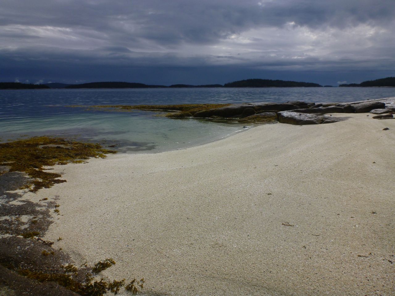
had to stop at the sandy beach at the head of Sand Cove, if only for a short stroll on the beach and a visit to the tent platforms. We had it to ourselves.


We still had most of the afternoon to meander six or so miles along the islands and ledges leading to Swans Island. It’s a good thing we brought helmets, since the small swell made for some perfect rock play conditions. Again, we lost track of time, trying to catch little waves through the rocks or bumping over pour-overs. We could have almost forgotten our destination. 


This relaxed quality to our afternoon would have been difficult if we’d needed to paddle the ten or so miles to get directly back. Instead, we found ourselves at the end of the day, paddling into Burnt Coat Harbor where we waited for the Nigh Duck, floating just offshore. In the late-day light, the harbor, full of lobster boats as well as visiting cruising boats, felt hushed. We ransacked our supplies for any remaining food and ate afloat, watching schooner passengers getting ferried in to the dock.


The Nigh Duck arrived and while the first passengers were shuttled to the dock, Hutch and I climbed aboard and hoisted our kayaks to the cabin roof. We got into some dry clothes and caught the last trip to the dock. Despite having lived essentially next door to Swans Island for the last fifteen years, I haven’t explored much beyond the shoreline, so it was a treat merely to walk along the road to get to the Oddfellows Hall. It was quiet, hardly any cars about, and I admired a few century-old homes along the winding asphalt.

The Oddfellows Hall is massive, a tall wooden antique of a building with the auditorium, holding well over 200 people, on the second floor. The performance was already in progress, but we were expected and a staffer ushered us backstage and into the front row before a packed hall. The Sweet Chariot Music Festival has been going on every summer for over twenty years, a three-night event that attracts performers, usually with a folksy bent, from all over. Since Swans doesn’t have much in the way of accommodations and the last ferry leaves for Bass Harbor too early, the audience is mostly island residents and visiting boaters. Before the evening performance, musicians pile into boats and visit the schooners in the harbor, singing sea shanties. According to some, some of the real musical highlights occur during the after-parties.

But we had to leave before the show was over so we could motor back across Jericho Bay, itself a dreamy experience. The stars were bright, and the moon, just past full, rose over the ocean. Occasionally, headlights flashed atop Cadillac Mountain and our re-entry into our neighborhood was made obvious by the bright lights of the Haystack school angling up the hillside on Stinson Neck.

Notes:
Hutch and Shari have a website called Freedom In A Can, where they share their blog posts, photos and helpful hints for those interested in their mobile lifestyle. They also write blog posts for The Dyrt.

The Sweet Chariot Music Festival happens around this time every summer. What a cool event: check it out!

Each act in the festival gets about fifteen minutes on stage. One group I particularly liked was a college-age trio from Camden called The Push Farther Project. They play a variety of instruments, including cello and other strings, and create unusual harmonies to sing what they call “documentary” songs that incorporate stories gleaned from other people’s experiences.

Trip #13 in my guidebook, AMC’s Best Sea Kayaking in New England covers Swans Island. Buy this book. Buy this book. Buy this book. Repeat after me… I will buy this book…


Monday, August 15, 2016

Around Swans Island in Four Days


We floated just off Devils Head, a granite bluff on Hog Island, at the edge of Eggemoggin Reach, a dense white wall of fog between us and our destination. R held the radio up to his face and made the call: Sécurité Sécurité Sécurité,: attention boaters in the east end of Eggemoggin Reach. We’re a group of 5 kayaks crossing from Hog Island to White Island, estimated crossing time, twenty minutes, standing by on one-six.


We paused, we listened: nothing. “Okay,” I said. “Let’s go.” Or I might have said “let’s boogie,” which I often seem to say in such situations. So we did. We boogied, but at that moderate pace that enabled us all to stay close together as we made the crossing. We were all following our compasses, but D paddled just ahead of the pack, the chief navigator who made it easier for us to follow the bearing without bumping into each other.


This was the fourth and last day of our around-Swans Island journey, a trip organized through Pinniped Kayak, and though I hadn’t exactly planned for this fog, it was, in a way, a good thing. I wouldn’t have been heartbroken had it lifted, but it enabled us to work on navigation and communication in a way that gave us immediate and obvious feedback… or consequences. 


The four paddlers in the group had come on this trip not just to have a guide, but hopefully to go home with some improved skills as well. They’d all had some previous instruction and experience, and at times I found myself wondering what they most needed me to teach, which were usually subjects provided more by the environment than any agenda. A four-day journey doesn’t lend itself as well to nit-picky strokes and maneuvers development as well as it does to overall journeying skills.


At every juncture I tried to put the route planning and decision making into the hands of the group. We had an overall plan: try to get around Swans Island, camping along the way on three probable islands. On the first day we left Old Quarry and took our first break on Saddleback Island, hoping to get across Jericho Bay to our first campsite on Marshall Island. But the winds blew in the mid teens, gusting into the low twenties – blowing with the flooding mid-tide current, but still likely to create some lively conditions for a 3-plus-mile crossing. Like the fog though, this was an opportunity for decision-making and for paddling in rough water that one might not venture into without the safety net of an instructor.


We could have taken the easier downwind ride northward. I would have been fine with that, but the overall consensus pointed us toward Marshall Island, so off we went, and soon found ourselves amid some considerable ups and downs. I’m sure we each have our own mental picture of what it felt like in those waves. At first, the skills learned in calmer water might be difficult to muster – the edging and efficient sweep strokes to keep from turning too much into the wind, the degree of skeg needed to avoid weathercocking. A couple of schooners blew toward us from Isle au Haut, sailing wing on wing, straight downwind, passing behind our sterns. We tried to stay close together without colliding, keeping a heading toward the northern end of Marshall Island, where, after an hour, we landed.


So we got the bumpy crossing out of the way, and that evening I think everyone felt some sense of relief and accomplishment as we ate our dinner and watched the sunset. Each evening we were treated to a display of shooting stars, as the Perseids meteor shower drew near, lying back and watching the night sky until we could no longer keep our eyes open. 


On Tuesday we wound through the islands south of Swans and made our way to Frenchboro Long Island, where we ate our lunch before heading to our campsite on West Sister Island. On Wednesday we followed the east shore of Swans up to Casco Passage and through the Black/Opechee group of islands before heading across the north end of Jericho Bay, to our campsite for the last night. 


As always, I often felt challenged to get people to focus more on the moment than the destination, which is more difficult when you have some miles to cover to get to your campsite. But that last evening after we’d made camp, I offered to go for an additional paddle around the island we were camping on, and half the group joined me, while the other half, a bit cold and tired, took a well-deserved break.


The distance around the island wasn’t much more than two miles, but we took our time, following each contour of the shore: around rocks, beneath bluffs and boulders, picking our way in empty boats through the mist and fog. Despite the miles we covered in the overall trip, and despite the challenges we’d overcome to get places, these moments were certainly the most peaceful, and perhaps most representative of why I paddle in the first place: the joy in maneuvering a boat well, the quiet connection to a place, those moments where your head empties of all the choices and chit-chat, narrowing-down to the path you’ll paddle among a winding, rocky passage.


As often happens on the last day though, the focus on getting there becomes heightened. We made a couple of foggy crossings and after the fog cleared, took one last break on the Lazyguts before heading back to Old Quarry for lunch.


Swans Island is Trip #13 in my guidebook, AMC’s Best SeaKayaking in New England. This version of the route is suggested as one of the alternatives, launching at Old Quarry Ocean Adventures in Stonington, rather than Naskeag Point, and focusing more on the surrounding islands than on Swans. We camped on Maine Coast Heritage Trust Islands (Marshall, West Sister and Hog). 

I have one more journey on the Pinniped calendar this year: The Downeast Journey, September 6 through 10. There may be space for one more person.


Here's a photo of me, courtesy of Rob Sidlow. Yep, that's a toilet and a tarp lashed to my stern deck.  


Tuesday, November 17, 2015

Good Places to Eat Lunch


A few days ago we went down to Popham Beach for some surf. It was a warm, moderate day with messy, confused seas, and strong winds shearing off the wave tops. Cold enough water to feel bracing when it slaps you in the face, but warmer than it will be for the next 8 months.  


It took a few attempts and some harsh beat-downs before we finally found the right spot and got into a groove that rewarded us with long rides. We felt drained and good during the long drive home in the dark, drinking coffee, re-living a few choice moments.


I go back and forth between touring and looking for excitement- usually a little of both. Lately we’ve gone on mostly calm excursions with friends, exploring Stinson Neck and Jericho Bay.

We’ve found new places to eat lunch and for Rebecca to paint, usually- it seems – returning home just after sunset, getting the most out of these fall days. We’ve been lucky to have abundant warm-ish days, and though plenty of people have put their boats away for the season, the water is warmer now than it will be in the spring when they put their boats in the water again.

  
When a friend visited last week, we took some drives to favorite spots: Mount Desert, Schoodic Point, The Bold Coast.


We hiked and gazed-out over big, impressive views.


There is something satisfying about looking out over vistas and understanding what you’re looking at because you’ve been in so many of these places, but I mostly find my eyes gravitating to the places I haven’t yet paddled, and there’s something satisfying about that too, knowing there’s no end to it.


But mostly we just paddle around, looking for good places to eat lunch.

Sunday, February 2, 2014

Bartlett Island


On Saturday afternoons we’ve been going to the pool in Bar Harbor for practice. The tough part, often enough, is loading and unloading boats in the wind and cold and worrying about icy roads; we’re not usually tempted to go for a paddle outside. This time though, with temps in the thirties and not much wind, we decided to do both: ocean in the morning, pool in the afternoon. We launched at Bartlett Landing, on the northwest side of Mount Desert Island, and set-off around Bartlett Island at high tide.

 
-->
I’d brought along the little point-of-view video camera, and we experimented with different set-ups as we made our way toward the south end of Bartlett Island. Ice coated much of the steep, shore-side granite, and at high tide we could cruise alongside, our progress a bit slowed by the desire for video.


I don’t bring the little video camera on every trip. The great thing about such a camera is that you can turn it on and it does the work while you continue paddling. Of course, after you’ve downloaded copious amounts of footage-- which takes time as well as storage space on the computer, you reign-in the shotgun approach and try to get footage that counts.


-->
One of the reasons I paddle is that it puts me in the moment. Any kind of multi-tasking is a challenge to appreciating the moment: even thinking too much can be a form of multi-tasking, like wondering about how I might write about this, if I should blog about it. It takes you away, spreads your attention thin.  

Does shooting video make it more challenging to be present and attentive to the moment? You are essentially looking for little pieces of experience to save for later, an artifact to bring home, as if that is the object of your quest, rather than the quest being the reward in itself. But using the camera could actually make you focus more completely on the moment. Certainly, taking photos and video does slow me down sometimes when I might be apt to just go cruising-on. I slow down to consider how something looks and end up looking far more closely, thinking about it, appreciating it.

 
-->
I’m not sure that doing something without cameras makes it a more pure endeavor, and I probably won’t find out any time soon, since I’m fairly addicted to image-making. The trend of posting on Facebook adds a whole other level to the question that I think I’d better stay away from for the moment, since we’ve got an island to get around here.


-->
The real highlight of the trip was the ice: the tall icicles in Dogfish Cove, the long expanses of thin skim ice we plowed through along much of the western side. In the distance, seals climbed aboard an ice floe. Paddling through the ice was hard-going and a bit surreal: the constant crunching sound against our hulls, the paddles penetrating just enough to move forward, leaving alternating holes in our wake. I worried a little about breaking a paddle, and a little less about damaging hulls, but we made it through okay, finally taking a quick break on The Hub before hurrying, with the tide, back down Bartlett Narrows to the launch.


Sunday, March 31, 2013

Great Gott, Black Islands


We drove along, happily chatting away with an entire sunny day of paddling ahead of us when I heard a little “thunk.” My foot came off the gas. Both bows still hung over the windshield, unchanged. But one of the tie-down ropes now dangled loosely, drifting down over the hood to the underside of the car, where it had previously been attached and taut. In the rear view, the tailgating dude was still right there, seemingly unaware of the his potential of being skewered by the pointy end of a Pygmy Coho-- a kayak-kabob. There was no room to pull over, but a turn-off loomed just ahead. We coasted toward it, watching the rope flop around until I turned, maneuvering the car off the road as carefully as I could... but the rope abruptly tightened and the bow jerked downward. I hit the brakes.


The rope had caught beneath the wheel, winding around it like a power winch, pulling the kayak down with it. I backed the car a few feet and Rebecca pulled the rope out, but the boat still angled downward. The roof rail had pulled one nut right through the roof, and ripped out of another. The clothesline we’d tied the stern with had snapped. Fortunately. Something had to give, and it could have been the boat -- in pieces, all over the road. We tied it all back together as well as we could and headed down the road... carefully. At Nate’s house, we added a strap around the whole thing, running it through the doors and inside the car. That held it. We proceeded to the launch.

The irony is that I’m extremely careful and worrisome when it comes to car-topping kayaks. The bow and stern lines, which are essential on a shorter roof, turned-out to be the weak link. So we’ll figure-out a system that can’t get beneath the wheels if it fails. In the meantime, well, I installed the rack myself, so I can fix it. More holes to drill, a little Bondo: no problem.


Later, we paddled out past the Bass Harbor Head light and followed the bar toward the meadowy north end of Great Gott Island. High tide had just passed, and a mild ebbing tide pushed us west. We paddled past The Pool on Great Gott and lingered in the narrows where the current had begun increasing.


Then we splashed around a bit among the rosy pink granite slots and ledges on the east sides of Little Gott and Black. We were eager to hear details from Nate’s five-star training trip to Scotland, which he provided in bits and pieces as we made our way to Little Black Island for lunch.

Nate had an afternoon commitment, so he headed back early, catching a few rides on the mid-tide waves over the bar. We hung-out for awhile on Little Black, just walking around, looking at the rocks and the big view of the open ocean.


We meandered back, making a big “figure-8” route: north around Black, south around the Gotts. The waves had settled-down over the bar by the time we headed back across, and we drove home without further mishap.


Wednesday, March 13, 2013

The Southwest Corner of MDI


At the launch in Bass Harbor as we got our boats ready, a fisherman rowed in and tied his dinghy to the dock. He saw our kayaks and told us “the seas are runnin’ big out there.”
    “We’re just heading up the shore,” I told him. “Staying in the lee... but thanks.”
    He looked at our boats. “I suppose that oughtta work.”
    I was grateful for the affirmation. It had been plenty windy lately, but that day it had died-down some, still coming from the east, and it seemed like a good day to follow the lee shore for a bit and get up into some coves at high tide. Still, I found myself looking out toward the islands, wondering. The seas looked flat enough - the classic lure of the offshore breeze that draws unsuspecting paddlers into quickly-changing conditions (see the latest Sea Kayaker).


We wove our way among the lobster boats in the harbor and followed the shore out toward Lopaus Point. The swell increased gradually. Out at Weaver Ledge, waves seemed to appear out of nowhere, stand up tall and explode onto the shallow rocks. We paused at the point, watching a few waves come in, but once we got around the point, all was calm.


The southwest corner of Mount Desert Island has plenty of private, oceanfront real estate, much of which is occupied by large homes. But there’s also plenty of undeveloped shoreline. We followed the contours of coves, meandered into a large salt marsh and ate lunch on a rocky beach. The sun came out.


We critiqued the architecture as we paddled. Rebecca leaned towards places with plenty of windows and porches, while I gravitated toward the occasional grandfathered boat shed or waterfront guest house- the more rickety the better. Nobody was home. Which made it easier to find a spot for our next break.


At Dodge Point, we turned around and headed back. We pulled out for a quick stop for the view at Rumell Island and hoofed it back to Bass Harbor, arriving shortly before sunset.


Wednesday, September 12, 2012

Paddling Home


There I was... boat all packed and ready to go on the beach in Bar Harbor. The students I’d guided all week were busy shuttling gear away from the beach, arranging big piles of drybags. I said quick goodbyes and slipped away, heading south. We'd come eight miles from Thomas Island on the north side of Mount Desert Island. Now I paddled toward a private MITA island just off of Great Cranberry, about twelve miles around the southeast side of Mount Desert Island.


Gliding past the Bar Harbor waterfront, I felt cut-loose, a little strange to be paddling alone; I could paddle any speed I wanted and not look back. Just past the breakwater at Bald Porcupine, I pulled into Compass Harbor and took a break on Dorr Point. Site of the former home of "Father of Acadia" George Dorr, the point is now part of the National Park and is a good spot for a breather before the next stretch, in which easy landings are scarce.


The coastline from Compass Cove to the southern end of MDI is a playground of rocks and ledges stretching five miles past sheer cliffs, undercut sea caves and towering rocky slots. Alone in my loaded boat with miles to go, I paddled conservatively, occasionally nosing into a slot or a cobble-beached cave... the sort of paddling that elicits constant wonderment, but also the sense that I haven't spent nearly enough time here and would need to return for more. I passed only two kayaks- a tandem and a single paddled by shirtless guys and a woman in a bathing suit- no life jackets- who appeared well out of their element in the minor swell. Just north of Schooner Head the private homes give way to the wild shoreline of Acadia National Park, and the people on shore begin; walking the trails, hanging-out on rocks (some literally hanging from ropes). After Schooner Head, Labor Day weekend visitors dotted Sand Beach and the stretch of granite shoreline from there to Otter Point. Happy to be alone, I stayed just far enough from shore to inhibit attempts at conversation.


Just west of Otter Cove, I pulled into a slot and landed on a cobble beach for a quick break before heading across to Little Cranberry Island. At the edge of the harbor I waited as several boats arrived, some driven by captains in blue blazers and khakis- arriving for the Islesford Dock restaurant's last night of the season. A little more paddling brought me to my campsite for the night.


A couple of other tents were set-up in the grass, but their occupants were absent. I carried my boat up past the tide line and set-up on a rocky ledge, eating my dinner as the sun went down and the full moon came up. A pair of kayaks appeared in silhouette, arriving from Little Cranberry. I met the paddlers later and we talked for awhile as it grew dark and the moon rose. They had come here on a whim, one from Portland, the other from Bath. They'd eaten dinner at the Islesford Dock restaurant, and planned on a leisurely Sunday. Again, headlights of cars snaked up the dark profile of Cadillac Mountain. With the fly off my tent, I slept in the moonlight, the barking of distant seals mingling with my dreams. Still in my sleeping bag, I watched the sun rise.


I had about twenty miles of paddling between me and Stonington, but I lingered over breakfast, enjoying the view of clouds easing through the hills on MDI. The sunshine lasted for a couple of hours, fading as I passed Great Gott Island and the Bass Harbor Head lighthouse. By the time I took a break on Placentia, a breeze picked-up, accompanied by intermittent rain.


Just before mid-day, I left the northwest corner of Placentia and pointed toward North Point on Swans Island. Despite the tide being nearly high and slack, the incoming current swirled back on itself as it squeezed into the mile-wide gap between the two islands, making distinct eddy lines. I hadn't noticed the "tide rips" indicated on the chart north of Staple Ledge before, but it looks like another place to investigate sometime at mid-tide and see what's happening out there. I passed the mouth of Mackerel Cove, and through York Narrows, stopping at a couple of small islands, just to check them out and have a sip of coffee before crossing Jericho Bay.


I wanted to get across Jericho Bay before the mid-tide current picked-up too much, so I pointed toward Scraggy Island and Eastern Mark Island behind it, and started across. 


After all the guiding and teaching I'd been doing over the summer, this respite of solo paddling felt good. Over the last week, I'd heard fairly constant banter as I paddled- rarely a quiet moment, my rhythm determined by those around me, paddling in fits and starts, my blade often moving through the water with minimal effort so that I would not pull ahead. It seems that if you paddle this way enough, your own groove will fade into the past, perhaps permanently. As I paddled home, I found songs popping into my head once again, and I went long stretches without pause. Weather and waves came and went without comment or discussion.


Passing Eastern Mark Island, I re-entered my home archipelago. The rain tapered away and the dark clouds passed behind me. The sun came out, and even though I looked forward to getting home, to a long soak in a tub of hot water, I wanted to savor the trip just a little longer. I pulled off at Clam Island- a ledge north of Millet. Beyond Isle au Haut the sky remained stormy and dark. I ate the last of my trail mix and finished-off the peanut butter and jelly; it would taste better now- as I sat on a rock that had been submerged a short time before- than it ever would at home.