I sat beside the lighthouse, watching the sun set between a nuclear power plant and a small mountain made of garbage. Eight miles of Biscayne Bay lay between me and that silhouetted shoreline where I’d begun paddling that morning after launching from Biscayne National Park headquarters. I’d followed the wild, mangrove shoreline north a few miles toward Miami, before taking an abrupt right turn across the bay. A couple of hours later, I could see the lighthouse on Boca Chita Key. I paddled toward it.
I was at the start of a trip I’d been dreaming about. I’d read as much as I could, and stared at the charts for hours on end, trying to anticiapate what I would find in each area: where to camp, the dangers and the sights, how the currents flow. I wanted to paddle the entire chain of the Florida Keys, north to south, a distance of about 150 miles, and since Rebecca was busy with her artist’s residency in Everglades National Park, I would do it solo.

I’d visualized that first day’s crossing for too long. I’d gone to the park headquarters and looked across. From the second story I could see the dim outline of Elliot Key across the bay, but from kayak height, all I could see was that aqua-turquoisey water surface stretching away to infinity. There were vast shallow areas that were a hazard to go around, but also a refuge from larger boats. I had my gear ready for a couple of days before the winds let-up enough to go for it. All that fretting paid-off; I followed my bearings exactly to the markers and found my way across without a hitch. That night at Boca Chita Key I sat in the dark, gazing at the city lights, savoring even the power plant, which would be a constant landmark for the next couple of days.

I established my routine by the third day: get up in the dark, launch at sunrise, and paddle 21 to 24 miles to my next campsite. I got a little lost in Jones Lagoon, a shallow patch of mangroves encased in islands; maybe not a good idea with a full day ahead, but I’ve started to enjoy the contrast between ocean paddling and poking around skinny water and overgrown passages. Later, I passed the exclusive Ocean Reef Club, a gated community that takes up the entire northern end of Key Largo. It was a fitting welcome to the populated portion of the Keys: huge houses with huge powerboats coming and going from the canals. The club emanated a constant din of children’s voices, splashing and distant motors. I drifted in among a family on short kayaks, the wife admitting nervousness about the channel up ahead, where someone’s personal mini cruise ship was motoring in. The husband snapped at her while the kids drifted into the wake of the large boat. I half-expected that, at any moment, someone would point at me and shriek, like in “Invasion of the Body Snatchers”, revealing the intruder in their midst. It was a feeling that would linger. The surprising thing though- and I found this throughout the Keys, was that, just beyond such a heavily-developed area, the mangroves began, and for the rest of that day I passed only a handful of houses before I found a campsite on an island.

The next day, to avoid some of the wind, I headed into Largo Sound and rode the current through the Adams Cut to the bay side. Here, I passed beneath Route One, which would be a presence all the way to Key West. For a few moments, I had a hint of what road-based visitors to the Keys experience: the hum of traffic, a billboard advertising a fireworks shop, and oh, by the way- it’s all for sale.
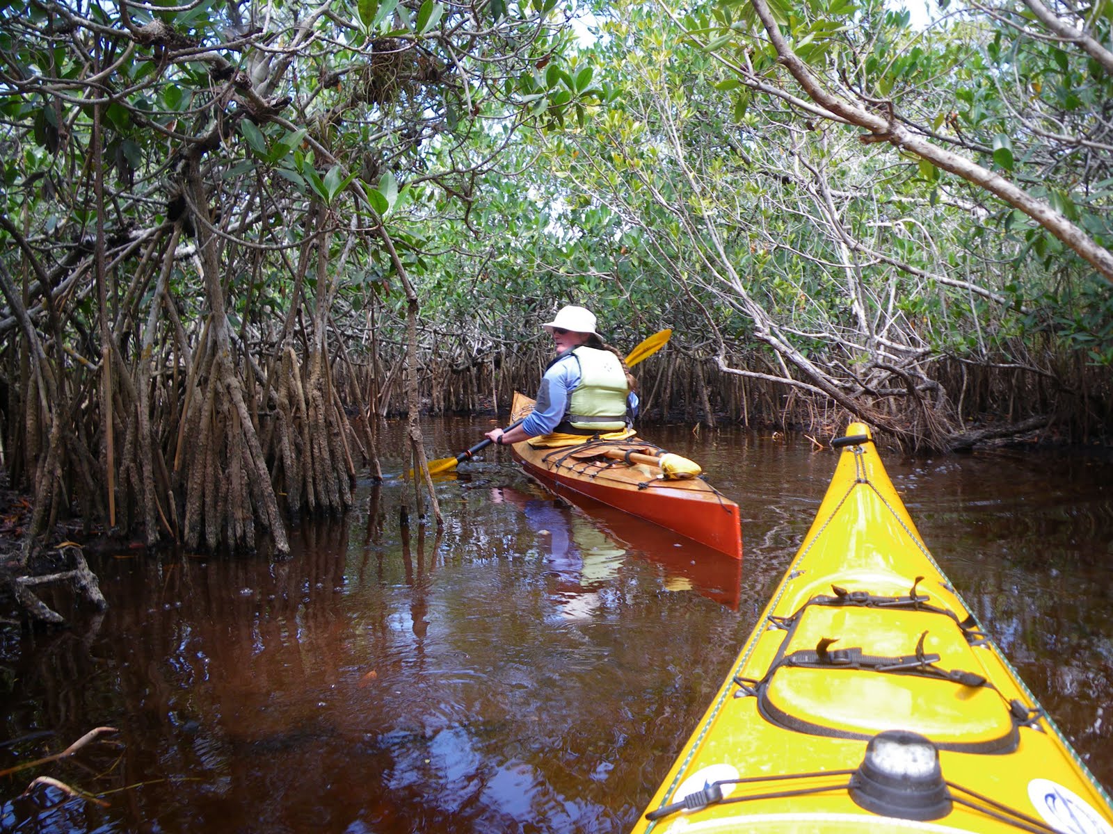
But the antidote is a short paddle away. Just off of Dusenbury Creek, I went into a section of mangrove tunnels called “The Grottoes”. There, in the leaf-filtered sunlight among the gothically arching prop roots, I found a stretch of calm, quiet water- a temporary respite before following the remaining, mostly built-up Key Largo coastline.

Later in the afternoon, I rode the current in Tavernier Creek back to the ocean side, and found another campsite that I shared with some wood rats. I woke a couple of times to discover one of the rats crawling up the mosquito netting above my head. It’s also worth mentioning that at these less-established, not so legit campsites, I tend to watch the rising tide with a little anxiousness. After all, it’s the full moon- just how how high will the water rise?

Plantation Key, Windley Key, Upper Matecumbe Key... private homes, motels & resorts, boat rentals, helicopter rides... One mile after another, I paddled, keeping the Keys on my right. As the day wore on the waterfront crowded with more people: couples in lounge chairs staring out at the sea, kids, spring-breakers... bikinis, drinks, big fishing rods, short plastic boats. Kiteboarders zipping out across the waves, occasionally taking to the air. It unrolled on my right as I paddled past, all entertainment for the solitary paddler. Ate lunch on Indian Key, walking the paths among the ruins of a former town.
By now, I’d become accustomed to sharks and rays passing beneath. At first I noticed small sharks in shallows, and occasionally some larger ones that circled around indifferently below. The rays undulated gracefully, taking-off abruptly when I approached.

One of the best deals for the paddler in the Keys are the primitive sites at Long Key State Park, which are held each day specifically for kayakers arriving by sea. Eight bucks gets you a sheltered platform with a picnic table, bathrooms and an outdoor shower... which you’ll need if you arrive at low tide, as I did. It’s a long, muddy carry. That night I sat and sipped my tea with the sea lapping calmly just below, sparkling beneath a full moon. Before dawn, one cruise ship after another hummed past on the horizon, headed for Key West.
The weather forecast for my sixth paddling day called for northeast winds picking-up in the afternoon. It also happened to be a day that would take me across some fairly open water south of some long bridge spans. The tide flows between the bay side and the ocean, squeezing through the gaps to create some strong currents and potentially dicey paddling, especially if the wind works against those currents. I’d begun thinking of the Seven Mile Bridge as the crux of the trip, potentially the most difficult section. If I made it that far, I ought to make it to Key West.

I made the Long Key Viaduct crossing first thing and progressed until mid-morning, when the wind increased, pushing me along, one hotel beach after another, guests looking up to see me surf past, until ahead lay a three-mile open stretch: the Vaca Key Bight. I tethered my paddle to my wrist, and headed across. It was a bit rough, but not rough enough to call it a day.
At the end of Boot Key, the Seven-Mile Bridge stretched away to the horizon with no end in sight. I could see my destination though: Molasses Key, where I would camp, over four miles away. I had little sense of what conditions lay ahead, so I plunged ahead, and it got rough. The waves behind me grew, and soon I became sadly aware of my kayak’s limitations. The boat was heavily-loaded, with over four gallons of drinking water in the cockpit. I was riding a little low. It’s one thing to ride waves in a following sea, but another when those waves start slipping over the coaming, pooling in the lap of my sprayskirt, slowly filling the cockpit. There wasn’t much I could do about it. With one hand I’d pull the skirt up and get the water out, but within a minute I had another gallon of water in my lap. I watched the bridge to gauge my progress. A large sea turtle surfaced and gazed at me for a moment before disappearing below, into its element. I could feel the added water in the boat making it less responsive. Somewhere in the middle, where the current was probably greatest, I found myself in a mogul field of waves. I focused on staying upright; forward progress was a luxury I could hardly think about.
But I got through it. I stayed focused on Molasses Key. Behind it, more land became visible, and eventually I could make out individual trees, and then I passed into a shallow area. I took a long drink of water and rested before paddling in to find my campsite.

I stayed on Molasses Key for two nights. As promised, the wind continued to pick-up: 25, 30-knot gusts. Thunderstorms threatened, mountains of high clouds building and passing by. A couple of powerboats anchored offshore, but the people in them never waded-in. I finished my serious book before lunch and began on the thriller. I made coffee and strolled around the small island, walking out over the ancient coral, surveying my little world from different angles. The wind hissed through the trees, weaving its sound with the flow of traffic on the bridge, a mile away. A double semi-truck of Coca-Cola heads for Key West, followed shortly by an identical red truck heading north. I’d watch the bridge and just space-out, finally breaking free, as if from hypnosis.
Maybe the isolation on Molasses Key was responsible for my choice to head to a KOA Kampground for my last night. After another long day of dodging the wind, I got into somewhat sheltered water and the usual pattern of overly-developed stretches alternating with wild mangroves. I was tired, and the prospect of a hot shower, dinner at a restaurant, a swim and a soak in a hot tub sounded good. Besides, the camera and cell phone batteries were almost shot.
Shortly after arriving, I wished that I’d just gone to the primitive site and stayed in my own, unshowered world. “It’s quiet compared to last week,” people told me, since spring break was winding-down. But it still felt like a tailgate party where the main attraction is warmth. A nearby trailer cranked classic hits all afternoon (which I found myself enjoying) and the shirtless guys with bandannas on their heads stood around with tightly gripped beers over their bellies, comparing tattoos or sunburns. I had a talk with a nice guy who really just wanted to talk about his hometown in Illinois, and when he finally figured out that I’d paddled there in that kayak, offered me a marguerita. Sorry, no, don’t drink, I had to say, as if confirming that I truly was from a different planet.

Freedom lay just beyond the mangroves, but few could see it. I slipped out quietly before sunrise and paddled the rest of the way to Key West. I got to the end of the island and turned back, waiting for Rebecca at the Southernmost Point, a large painted buoy on shore, where visitors took turns having their picture taken. There is nowhere to land nearby, so I drifted in the small waves, watching occasional person-sized sharks swim by below, until finally Rebecca appeared at the fence and waved. It was my turn for a picture.
9 days (1 weather day) 8 nights, about 157 nautical miles.