Sunday, February 6, 2011

Fresh Tracks on Green Island

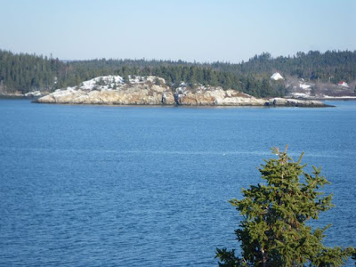
Wow- sunshine, temps in the lower thirties and not much wind. Not only that, but several feet of fresh snow on the ground; I had to get out. I also wanted to make the most of the snow, so I strapped my old snowshoes onto the bow and headed out.


Last weekend we'd gone to Mount Desert Island for some cross-country skiing in Acadia National Park before our late afternoon pool session with the kayaks. The skiing was amazing- miles of groomed trails on the carriage roads. Most winters lately I've been content to skip those other, non-paddling winter sports, but the snow this winter is too good to miss. We were worn-out by the time we got into the pool, but still managed two solid hours of rescues and rolling and such. The repeated practice is crucial, especially if one is paddling in winter. It's been a few months since I dipped my head in the ocean.


In the summertime, this would have been a typical after-work paddle: out around Steves and McGlathery and back. This time, as I passed Green Island just after high tide, I found myself lingering beneath the big rocks where caps of snow melted in the sunshine.


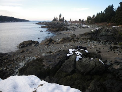
If you ignore the heaps of cast-off granite blocks and the fishing debris, the islands usually feel fairly pristine. Add a fresh coat of deep snow, tracked only by animals, and it feels almost primeval out there. Beside the pure white, the blueness of the sky and sea is punched-up to its bluest levels, and the spruces embody the meaning of the word "green". As I drifted I had this feeling that I often have while paddling- that I could hardly believe my good fortune. And I could have just as easily not gone paddling: stayed home to clean the apartment or something. So the apartment remains messy and I've had at least one moment when I consciously feel privileged to be seeing what I'm seeing. A moment like that now and then helps get one through the more mundane times.


The wind picked-up as I went around McGlathery Island, and soon, a long front loomed in the western sky- the next storm. By the time I landed on Green and strapped the snowshoes onto my kayaking boots, the sunlight had drained from the sky, and it felt like more snow could come any time.


I chose Green because it has a well-maintained trail, thanks to Maine Coast Heritage Trust and its volunteers. Without that, most of the islands have blown-down trees and undergrowth that could be pretty tough-going on foot- let alone snowshoes. I followed a loop trail through the woods, pausing at an overlook above an old quarry. As I took-in the view: a slightly higher perspective of familiar islands in the foreground, Mt. Desert in the background, it occurred to me that I'd never even hiked that trail before. It's probably less than a mile from where we've lived for nearly eight years, and I'm only just now getting there.


Amazing. And there's still plenty more I haven't seen.

Friday, January 21, 2011

The Lower Bagaduce


Lately I’ve been watching the weather forecasts compulsively, but if someone asks me if it’s supposed to snow I’m likely to draw a blank. Pretty much what I get from it is the wind and temperature, which results in either yes or no: paddling or no paddling. The past week and a half has been a lot of “no” days, with some “maybes” thrown-in just to tantalize me and make me feel bad when I don’t go. Yesterday was one of those maybe days, but I thought I might find some semi-sheltered paddling in the upper Bagaduce River. The tide was even right to launch into the shallow waters off the Penobscot Town Landing.


Unfortunately, Winslow Cove was iced-in, so I drove down to the launch by Bagaduce Falls. The current squeezed beneath the bridge, frothing-up a formidable wave train, but at the next bend in the river, ice covered the entire surface. I sat in the car for awhile watching the standing waves. Occasionally a huge ice flow emerged, tossed about the crests of waves only to be abruptly pulled beneath. So maybe the upper Bagaduce is out of the picture for the next few months.


Fortunately, the road into Dodge Point was plowed (at middle right on the above chart) so I unloaded there at another of Brooksville’s town landings. I called Rebecca with a revised float plan and I was off.


I follwed the steep shoreline toward the head of Smith Cove, where pines clung to the tops of dark cliffs, dripping with icicles. The sun felt good on my face. It was a crisp, clear day- a bit cold, which meant I had to keep moving. I did- paddling around Smith Cove and out between Whites Head and Hospital Island. The current was picking-up, barely floating me over over the sandbar between islands. Across the river lay the Castine waterfront, dominated by Maine Maritime Academy’s training ship, the State of Maine.


As I approached the mouth of the river, a stiff breeze felt icy on my face, and a minor swell came rolling in from the northwest. I headed for Ram Island. The island is owned and managed by the Conservation Trust of Brooksville, Castine and Penobscot, and has a small campsite. I took a walk around the eastern island, but in the face of the northwest breeze, a chill quickly set-in. Good thing I’d worn an extra layer of long johns, but the feet and toes start to take on a chill that doesn’t go away. The best thing is to keep moving, keep the blood pumping.


I was going to head straight back to the launch, but after a few minutes of paddling I felt fine again, and I couldn’t resist crossing over to Castine to paddle alongside The State of Maine. By now, if I paused the current pulled me backwards. I paused for some photos of the ship, but there’s something intimidating about being next to- actually below- such a large vessel.


I crossed the river back to Smith Cove and paused at the remains of another large ship. The Gardiner G. Deering was a 251-foot, five-masted schooner. Abandoned in the 1930s and later burned, the ship is now reduced to a few skeletal, rockweed-draped timbers- just enough to give you some sense of her original proportions as you paddle through.

Back at the launch, I cranked the heat in the car and loaded-up as the sun set. I felt lucky to have squeezed a paddle into a rare window of good conditions. Well, "good" conditions when I lowered my standards because I could see it wasn't going to get much warmer... and when I sought-out a place with less wind. Good thing I got out; today looks much different.


Saturday, January 8, 2011

Putting Together the Pieces


Lately I've been launching from Reach Beach, in Gray's Cove, on the northeastern corner of Deer Isle. A launch site can become a habit. I find myself in the car, and of all the places I could launch, I head back to the same one as the day before. Maybe it's more obsession than habit. It seems that every time I'm out paddling, I leave one place that I didn't get to- an island I didn't quite have time for, or an inlet I couldn't follow because the tide ran out. And at night, I pore over the chart, and if I can't picture the place in my mind, I can't wait to check it out.


Maybe it's a weird obsession, but I find it immensely satisfying when my route re-connects or overlaps with previous routes I've paddled, and somehow the big picture starts to click together like pieces of a jigsaw puzzle... a multi-dimensional puzzle that somehow manages to include changes in tides and weather and even my own experiences.


Reach Beach is public, thanks to a conservation easement donated by a generous private landholder to Island Heritage Trust. There's often someone out digging clams on the mudflats or walking on the beach. You can park your car just off the road, at the top of the beach and, unless it's an hour and a half on either side of low tide, carry a short distance down to the water. For those three hours around low water, there's a bit of a carry through the mud.


It's tough to completely avoid the mud, so I just accept that occasionally I have a long walk. Like in this photo. Low tide and sunset happened at about the same time, so I had a good long carry. I've had to spend a little extra time cleaning gear in the evening.


Reach Beach gives the paddler fairly quick access to several distinct areas. One day I crossed the Reach and followed the Brooklin shore. The landmarks gradually become more familiar- the church steeple rising above the trees from the center of Brooklin or the snowy hills of Mount Desert. Sometimes Blue Hill pokes above the trees, and that that island with the cliffs has to be Hog Island. Eventually, a glance here or there lets you know in an instant where you are.


Another day I paddled among the islands off Stinson Neck, then crossed over to the islands off of Naskeag Point. Large rafts of eiders and longtails murmured not far away, while occasional shotgun blasts thumped in the distance. I'm not the only one with New Year's rituals.


One excursion at high tide took me for a tour around Greenlaw Cove, exploring Fish Creek and all the little nooks and crannies I could find. It was a foggy day, and it felt good to follow the shore, but those inlets add-up; that turned into a fifteen-mile day.


Of course, the more I spend my evenings staring at charts, the more creative my route-planning becomes. For a long time I'd heard of people portaging "The Carryover", a traditional canoe portage route into Long Cove. I thought I'd give it a try, so I set out at high tide, carried my kayak over the road and re-launched in Long Cove.


The ice was a little thick; I couldn't get through and had to turn back. I must have been in the mood to carry my boat, though, since I managed to portage the Sunshine Causeway, paddling around Stinson Neck.


Well, it's always good to leave something undone. The puzzle, it turns-out, can never be completed; it just grows.

Monday, December 27, 2010

Christmas Paddle

On our calendar for December 25th, Rebecca had scrawled- in ink- “go kayaking”. No doubt we were hoping for a repeat of last year’s calm day on the water. It may be a little weird to make an appointment, but if we didn’t, chances are that we would end up with something else on the calendar, and we would find ourselves chatting with someone, probably about kayaking, wondering why we weren’t paddling.


As Christmas wishes go, this seems a modest desire, but the weather forecast wasn’t promising. As I bopped around the kitchen to my once-yearly listen to Dave Brubeck’s Christmas album, the north winds began subtly diminishing. By the time I had a casserole ready to go in the oven, it was obvious: time to get the gear together. I put the casserole in the fridge.


We paddled away from the launch. The air temp hovered in the mid-twenties and the sun slipped behind the clouds. We would need to keep moving to stay warm. “Where to?” we asked, but our bows were already pointed toward the sloping profile of Steves Island.


Funny, how often we head for Steves without thinking about it. It’s two miles away- maybe a half-hour paddle if you’re going non-stop, like we were. Maybe because the island is state-owned, and because we’re its “island adopters” for MITA, we feel some sense of ownership (as obviously many other people do). Maybe ownership isn’t the right word- try “stewardship” instead. We’d thought we might stop and pick up garbage- I could see some of the usual fishing debris, but it was cold enough and late enough that it made more sense to keep moving. We stopped short of going around the island, not wanting to disturb the huge raft of ducks on the south side. We headed around St. Helena and back toward town.


When we arrived back at the launch at sunset, we paused. Stonington was about as quiet as we’d ever seen it. There were no boats moving about the harbor, and the town felt subdued, lights coming on in windows here and there. Usually we don’t paddle much in the harbor. It is the domain of fishing boats, probably far more dangerous than anything else we might encounter in our kayaks. But it was so calm and quiet, we had to check it out, following the piers right into our neighborhood. I hovered in the water just across the street from our building, below the lit-up Christmas tree on the deck at the Seasons of Stonington restaurant. A couple of cars chugged past. In the front window of the gallery, a light came on, triggered by a timer, spotlighting Rebecca’s most recent close-up of a lobster boat bow.


It was high tide, so we were able to maneuver among the ledges, over toward Green Head. There were lights on in a few houses, and strings of Christmas lights strewn in the bushes and trees. Framed in a bright window opening, a woman stood at a kitchen counter. Most of the windows though, remained dark. Somewhere, a dog barked. The quiet was overpowering. We drifted awhile among the lobster boats, our toes and fingers beginning to turn numb, and headed back in. A casserole awaited at home.


Oh yes, since it’s Christmas, I should expound on finding something spiritual in nature. You know- the obligatory bla bla bla about what the holiday means to me, being a transcendentalist in the tradition of Emerson and Thoreau. Hmm... let’s not. Let's just say it was awesome, as it is every day, and leave it at that.

Tuesday, December 21, 2010

"I Really Like This Place"

On Sunday I launched from Causeway Beach and headed south. It’s funny how sometimes I look at the chart before the trip and get all kinds of big route ideas- the distances covered, the islands circumnavigated, but after about forty-five minutes of non-stop cardio, that all goes out the window. Sunday was sunny, thirty-ish, calm. I had all afternoon.


Pickering Island lay ahead and I looked forward to cruising along its long crescent-shaped beaches, which, with the low winter sun, looked cool in the shadows cast by the spruce forests. Around me, the surface roiled gently. The tide was going out, just about mid-tide now, and it surprised me how much current squeezed through these small islands and ledges. I paused to let it turn me here and there. Maybe that’s when everything slowed down.


My bow pointed toward a ledge- a small island really- a hump of stone rising from the sea. So I paddled over to it. A crow cawed at me and flew away. Maybe at a lower tide I could find a landing here and climb up, but for now I felt content to drift past.


I came to a beach on a small island and got out for a look around. Privately-owned with a conservation easement managed by the Nature Conservancy, the island’s public access status is perhaps a bit ambiguous... but not in December. I tramped through the snow, up though grassy meadows to a bluff overlooking a broad expanse of Penobscot Bay. I kept saying to myself “I really like this place... wow, I really like this place!” True, I say that about all the little islands, but for a moment there, I fell for this one.


I followed the shoreline of Pickering Island around and headed over to Crow Island. This five-acre island is state-owned, and was once even on the Maine Island Trail (check out this article by Dave Getchell Jr. in the May 1989 issue of Backpacker Magazine).


Eagle nesting may account for its current exclusion from MITA, but again, that’s from April through August. Of course, I couldn’t help looking around and thinking about where I’d put my tent: in the meadows, beneath the stands of spruce, overlooking the pocket beaches where the smooth stones clattered with every wave- one could hardly go wrong. Again, I caught myself saying “I really like this place...”


I crossed back over to Deer Isle, aiming for Heart Island, and as a nearly full moon rose above my bow and the sun fizzled into the clouds on the horizon behind me, I followed the shore back to the causeway.

Monday, December 13, 2010

Icicles

With the ups and downs our weather brings us this time of year, I end up checking the forecast compulsively, watching for windows of opportunity. There wasn’t much wind on Friday, but it sure felt cold. I didn’t get out, but as usual, wished that I had. It helped that on Saturday the air temperature was forecast to rise into the 30s, with not much wind, and possibly even some sunshine. Once again, I headed over to the ramp in Bucks Harbor, this time, heading southeast, down Eggemoggin Reach.


The shorelines of Brooksville and Little Deer Isle are separated by Eggemoggin Reach, only a mile or so across, but each shore is distinctly different from the other. On the Brooksville side, the settlement is concentrated mostly into one area, from Norumbega, an old enclave of summer cottages overlooking Deadmans Cove, to Herricks. The rest is fairly wild. Low cliffs rise directly from the water, topped by scrubby, twisted pines.


Of course, there are layers of history here, visible if you know where to look. A sheltered cove known as “The Punchbowl” was apparently an Indian village, and its mud covers the remains of a trading ship that was destroyed and burned, killing all aboard. There’s still tension between locals and People From Away, but maybe a little less extreme.


The sun came out as I crossed the Reach. This stretch of Little Deer Isle shoreline is thinly-settled, with plenty of forest between most of the houses, and an overall gentler, less cliffy shore than the one across the Reach. I pointed toward the one section of low, overhanging cliffs, and as I neared it, I remembered that there sometimes is a reward for getting out in the colder weather. In this case: icicles.


Forward progress stopped. I drifted and marveled: totally unexpected. A gift.


Soon, I stopped long enough to eat a sandwich, which was long enough for my toes and fingers to turn numb. I paddled hard for Thrumcap Island and heated-up again.


I stopped there to check things out- the nests on the rocks, a nice view up the reach toward the bridge, a desolate grandeur so close to home- and I could imagine whiling away a warmer afternoon here. But my toes were numb. So I got moving and warmed-up as I headed the two miles up Horsehoe Cove, returning with a little push from the current.

A half-hour after sunset, I paddled into Betsy's Cove. In the dim light, the water surface below the ramp had a dull sheen. I plowed into it and came to a stop. Ice. I paused for a moment, just to savor the scene: a winter evening in a New England town, yellow light from occasional lit windows, thin crescent of a moon overhead, and somewhere, the crunch of tires over ice and snow.

I'll admit that when we get a little cold weather, I complain a little like most everyone, and lately I've been remembering how nice it was last winter in the Everglades. But would I completely give up one for the other? Can't have everything, I guess. This is where I am now. I backed out of the ice and found my way around its edges, back to shore.

Monday, December 6, 2010

Cape Rosier

With the forecast calling for some wintry weather for the week ahead, the weekend looked okay: air temps in the the 30s with light winds out of the north. It’s all relative. Knowing it would soon be colder and stormier, I decided I’d better make the most of it, so on Saturday I drove to Brooksville and launched at Betsy’s Cove town launch in Buck(s) Harbor.


If you paddled directly from Bucks Harbor to Blake Point, you’d go just over three miles, but the southeast shore of Cape Rosier is indented with coves reaching far inland, multiplying the paddle-able shoreline to over twelve miles. I launched just after high tide, so my timing was off, but I was eager to check-out Horseshoe Cove. This narrow finger of the sea stretches over two miles inland, with a zigzag about half way in.


The half-hour paddle to the mouth of Horseshoe is past surprisingly unpopulated shoreline. Condon Point is undeveloped (and for sale- hey land trust people). I knew I was paddling against the flow, but it wasn’t obvious until the cove narrowed in front of Seal Cove Boatyard. I dodged the current, following eddies where I could, rounding the corner into the zigzag, where I encountered a constriction creating a tidal rapids.


I got out and watched it for a bit and ate the first of my sandwiches. Definitely a spot to check-out at other tides. And there’s more than a mile or more still to go upstream. I headed back out just in time though, scraping along the bottom just south of the boatyard.


The mouth of the cove is marked by Dog Island, a small island connected to the mainland by a sandbar at lower tides. Next is an area called “Barneys Mistake”. I’m not sure who Barney was, but I would guess his mistake had something to do with the numerous ledges here. The cove is looked over by a few residences, closed for the winter. Actually, that can be said for pretty much all the shoreline in the area- all privately-owned with discrete cabins that have been there for generations.


I paddled as far as Bakeman Beach, then headed back via Spectacle Island and the Thrumcap, arriving back as it grew dark.


On Sunday, I picked up where I left-off, launching at Bakeman Beach, which is owned by the town. I parked just off the road, at the top of the beach and headed west, out around Head of the Cape. Here, I felt the wind in my face and paddled into small wind-driven waves that collided with the steep, rocky shore. This would obviously be a committing section of shoreline, so I took a moment for a reality check, considering the risks versus my preparedness.


Reality check out of the way, I followed the shore north. A couple of obvious bailouts stood-out, predictably in Ames Cove, Orr Cove and the coves approaching Harborside. The grey sky spat out sleet and snow, sometimes veiling the shores of Islesboro, Dice Head in Castine, and in the distant north, Sears Island and Cape Jellison. I ate my sandwich on Holbrook Island, beneath the watchful gaze of a bald eagle, and headed back the way I’d come, arriving back at the beach just before dark. I saw no other boats underway all weekend. It’s been fun to car-top the kayak to other launches, paddling unfamiliar shoreline, connecting the dots with previous trips. But now, with the kayak and the car obscured by snow, I may want to put the boat away for a few days.


We just watched a video about Andrew McAuley’s 2007 fatal attempt to kayak from Tasmania to New Zealand. A very sad, but amazing story. You can watch it for free here.