Tuesday, September 28, 2010

Kimball Head


Yesterday the winds came from the southeast, so Nate and I thought it would be a good day to spend some time in the lee of Isle au Haut, paddling around Kimball Island. It was getting toward high tide as we paddled out, pausing for awhile among the boulders off Hardwood Island. At that point, the seas were fairly calm, with only an occasional small swell rolling in among the boulders: good conditions to practice without the consequences that bigger waves bring with them. The boulders offer a maze of pathways. You can glide into one and quickly shift direction as other avenues present themselves. Sometimes a small wave breaks and you need to choose to either ride it out, turn into it, or risk getting pushed sideways, probably into a rock. We tend to spend a lot of time doing some fairly extreme edging to make tight turns.


We took a quick break when we arrived at Kimball Island, then headed around Kimball Head. For the most part, the seas were still fairly calm, but it doesn’t take much to make things interesting among the rocks. We found a small wave that we surfed in a few times, always ending with a 90-degree turn at the end of the ride, just before the wave hit the rocky shore. We backed into a few slots, and basically just paddled around, looking for trouble. Nate demonstrated the fine line between rock gardening and “amphibious paddling” when he frequently ended up on a ledge with no water beneath his hull. This continued on around to Marsh Head, just before we headed north through the Isle au Haut Thorofare.


Of course we were having fun and stayed out there longer than we should have. Nate had parental duties to get to at home, so the last five or six miles were fairly straightforward “let’s get home” paddling with a 15-knot beam wind. We wished we could have temporarily transformed our boats into long, straight racing craft to make the slog a bit quicker, but given the choice, we’d still go for our sporty, turny craft most days, since they take us into places that longer boats just can’t go. It started raining before we arrived back at the ramp- a cool, soaking rain, which only seemed to immerse us in the elements that much more.

Sunday, September 12, 2010

Eggemoggin, Swans, Frenchboro-Long Island... Part II

Pond Island to Pond Island

I awoke in my tent. Outside, the salt marsh had returned to its grassy incarnation- only water here and there. The previous night felt like a dream. We had a laugh over it as we ate breakfast, but for awhile there in the night, nothing had been certain as the dry land around us disappeared.


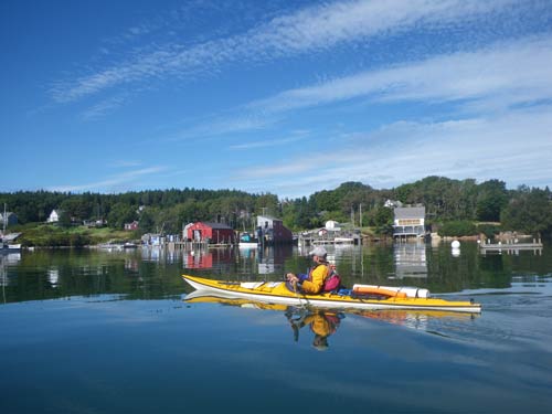
We would spend the day heading east through Eggemoggin Reach, and if we had time and energy, across to the islands north of Swan’s Island. We crossed over to Pumpkin Island Light and paddled along the north shore of Little Deer Isle at high tide, where we discovered a stone arch just big enough to paddle through. As we paddled along the Sedgwick side of the Reach, we encountered far more sailboats than we usually see in the archipelago. The Reach is famous among sailors, who seem to favor the middle of the channel, far from the details of shore. And the details along shore? Pastoral, old salt water farms. Tangled trees in overgrown orchards dropping wormy apples onto the shore. Boatyards, fancy homes, rustic cabins... all the usual stuff we find ourselves looking at while paddling in more ‘civilized’ environments. We began to feel sleepy.


On Sellers Island we met a man in pajamas, just unloading his kayak... a process that accelerated as we approached. We assured him that we were only stopping for a break, but he seemed to want us to stay. We told him we were headed to Pond Island- a different one from our previous night’s Pond Island. “No, no,” he said, “You don’t want to go there. Mosquitoes will carry you away.” Nor did he think any of the other islands were particularly good ideas- on one he’d encountered a bear. He seemed almost disappointed that we were sticking to our plans. “I don’t snore,” he added as we pushed away from shore.

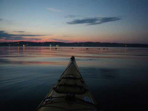
There were indeed mosquitoes on Pond Island, but we ate dinner out on the ledges where a slight breeze kept them at bay. We had only a couple hours of daylight before retreating to the tents. I stayed up for awhile, going over charts as Bass Harbor Head Light flashed red in the distance.


Pond Island to Big Baker Island


In the morning fog we made our way to Swans Island. For awhile, we avoided the southwest wind by paddling in the lee of the island, finally hopscotching southeast past the Sister Islands, where turbulent waves had formed. It seemed too soon after high tide to be merely the result of tidal currents, so we thought the waves had been formed by the strong winds funneling through against the current. As we paddled across the gap, Todd marveled at the brilliant light on Great Duck Island. As we looked, the eastern Sister quickly obscured Great Duck- were we moving backwards? At about that time we noticed the waves- big waves- getting closer to us- we shouted over the roar, realizing that the current was pulling us into a tidal race.

(...tune in next time for the conclusion of our story...)

Todd smiled. “Wanna go in?”
“No,” I paddled as hard as I could, not pausing until I was well out of the current’s grip. Maybe it would be fun to play on sometime, but it didn’t look inviting then. Todd pointed out that we’d probably just ride it backwards or capsize and get spat-out on the other end. Yeah... and your point?


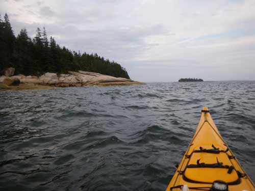
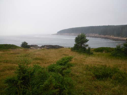
We kept going. We had more challenges to face. We’d wanted to get to Frenchboro-Long Island for a long time. The 2500-acre island has a small fishing village at Lunt Harbor on the northern side, but the rest of the island is wild, mostly protected by Maine Coast Heritage Trust, and exposed to whatever the open Atlantic sends its way. Rich’s Head juts out to the southeast, connected only where two large coves pinch inward. We took a break at one of these, Eastern Cove, and took a peek at the conditions on the other side. It looked... a little rough maybe, but do-able. Once we went around the head, the shoreline would turn steep and rocky, with little opportunity to bail out for several miles.

For the moment though, we marvelled at what a wild, gorgeous place we were in: grassy, boulder and spruce-strewn meadows overlooking vast coves on either side. We would have been happy to stay there and check-out some of the island’s ten miles of trails, but unfortunately, camping isn’t allowed.


As soon as we rounded the end of Rich’s Head, it was obvious that the next few miles would keep us on our toes. Swells rolled in from the south and crashed thunderously against the pink granite shore, rebounding out to where we bobbed up and down. We moved a little further out. And the fog came in, so when we rounded the next point, the top of the island was obscured. I had little sense of scale; were those cliffs? Were we looking at trees? A lobsterboat motored past, lost from sight every time we descended into a trough.

Of course, in most of the photographs (when I had the presence of mind to take them) it appears that we’re paddling on a nearly calm sea. It feels as if you should be able to point the camera anywhere and it would somehow capture some of this, but later we could almost start wondering if it were all a dream. The weather buoys put the waves at that time in the 4-5-foot range- not exactly monstrous, but still something to contend with. Maybe it’s time to get into video.

We pulled in for a quick look at the town, but didn’t have time to disembark. The fog had come in thick and we needed to navigate through it to find our way to our campsite on Big Baker Island.


Big Baker Island to Stonington


On Thursday, our last day, we continued our survey of the Swan’s Island shoreline, checking-out the town of Minturn and Toothacher Bay, where we had lunch at Fine Sand Beach as it became submerged by the extra-high tide. On Marshall Island we visited the beach at Sand Cove, before embarking on the swelly, four-mile crossing back to Fog Island, at the edge of our own archipelago... our home.


It had been a good four days- five days for Todd. We'd explored places just beyond our usual paddling range, and even discovered something new on our own island (if Little Deer Isle counts as such). In some ways, trips like these seem to make us feel a bit more at home right where we are, knowing better what lies just "over there", demystifying those areas of our charts that we'd stared at for so long, wondering... Which is what I've been doing again the past few days. Every time you discover something new, you become aware of how much more there is to see. How will we ever find the time?

Saturday, September 11, 2010

Pond Island

Monday morning. A half-hour after launching from Stonington, I paused at Andrews Island and looked out across East Penobscot Bay. The tide had just peaked an hour earlier, and I could barely make out the bluffs on Babbidge Island, my target for the three and a half-mile crossing. I took a bearing and began paddling.

A day earlier, Todd had done the same, but faced a fierce headwind and confused swells- remnants of Hurricane Earl, which had lost steam as it hit the cold water of the Gulf of Maine. Fortunately for me, I faced minor wind, brilliant blue skies and a low, pleasant swell as I crossed. Far off, a few lobster boats circled as they hauled traps.

Burnt Island

This would be the first of four days out in our kayaks- possibly longer for Todd. Our itinerary was flexible, subject to the weather and our whims. Half-way across the bay, I paused. To the south, Brimstone Island rose from the horizon. To the north lay the archipelago spread out between North Haven and Little Deer Isle. As I came nearer to North Haven, the current increased, pushing me south. On the other hand, the forecast called for increased winds from the southwest, pushing us north.

Colt Head Island

I met Todd on the beach at Calderwood Island, and as we had a snack, decided that, with the increasing winds, we should head north. We paddled along North Haven, took a break on Burnt Island, and out into the area- the archipelago between North Haven and Little Deer Isle that really needs its own name. It’s a nice neighborhood; we passed the Fuller’s (as in Buckminster) Bear Island, the Porter’s (Fairfield & Elliot) Great Spruce Head Island, as well as the Cabot’s Butter Island. Not that those people had any effect on our paddling experience. By then, the wind had picked up, and we did plenty of sweep strokes in the following seas.

The campsite on Pond Island

That night, on Pond Island, we made the mistake of camping in a spot that wasn’t the designated campsite. By the time we landed, the winds had picked-up considerably, and we found a spot out of the wind behind a beach rose-covered dune, on the edge of the salt marsh that gives Pond Island its name. Perfect. As it grew dark though, I stepped in water where I hadn’t remembered it before. I didn’t think much of it until later, when I noticed the formerly grassy area was now reflecting the stars. “Todd,” I said, “I think we have a problem.”


Since it was one of the highest tides of the month, we weren’t quite sure how high it would go. And on the other side of the dune, the high tide would be augmented by wind and waves. We pulled the boats up as high as we could, took the tents down, and waited for high tide. Bioluminesence lit the water like clouds of tiny fireflies. Over on the mainland, we recognized familiar landmarks like Caterpillar Hill, lit now and then by headlights passing over its ridge. The water rose until we had maybe three or four feet of sand between it and the beach roses. We marked its progress with sticks, until finally, it began to recede. Then, we stretched out as well as we could in our sleeping bags- no room for the tents- and slept beneath the stars.

Later, when it began to lightly rain and the water had receded, we put the tents back up, leaving glowing footprints in the sand.


Friday, August 27, 2010

A Guide's Progress

You’re probably wondering about that story that began on this blog back in early May- when we began training to be Maine Sea Kayak Guides. It has been a longer story than I anticipated. We took the class, as well as the first aid classes, finally scheduling the exam in mid-July. We’d studied plenty- we thought- and left at five one morning to make the two and a half-hour drive to Augusta. It didn’t go as well as we’d hoped. We both did well on the hour and a half written test, but failed the oral exam. On the navigation section, Rebecca neglected to mention one word- magnetic, and wasn’t allowed to proceed further. I didn’t cover enough material on my pre-trip briefing.

We didn’t feel too bad about it- plenty of people fail the first time or two. It’s supposed to be tough. It should be tough. We scheduled a re-take and continued studying. We practiced the pre-trip briefing again and again, which could take over twenty minutes if they don’t cut you off. This time, we scheduled the exam for an afternoon. We felt ready.


Hypothetical scenarios make up much of the exam. You’re essentially role-playing with the examiners. We stare at the chart as they throw us into these situations where things go wrong, and they’re waiting to hear what they think is the right answer, and how we go about problem-solving. They interrupt us frequently, asking questions, often incredulously: you’d do what? It’s hard to tell if they’re just trying to make you doubt yourself and not stand your ground, or if there’s really some other thing you should be telling them.

As far as we can tell, the examiners may have never been in a sea kayak in their lives. They’re Marine Patrol and Inland Fish & Game people. So it seems they’re waiting to hear very particular things from us that qualify as correct answers. Theoretically, the candidate has plenty of paddling experience and can actually perform these rescues that we demonstrate with model boats, but there is no practical, on the water part of the exam, and it is possible to lie about your experience, talk the talk and sound convincing enough without ever having paddled a kayak.


We’ve paddled a good deal more than a lot of other candidates, and we had a difficult time. In the end though, we both passed. We have our licenses- even patches and decals that identify us as Maine Guides. For now, mine are magneted to the refrigerator door.


But maybe the real test came two days later when I had my first chance to guide a trip out of Old Quarry. A detailed description would sound pretty much like one of the scenarios from the exam: a group of nineteen clients in ten boats led by a co-guide and me, wind & waves, a client’s broken paddle... For a few moments, as the events seemed to unfold in slow motion, I could almost hear the scenario in my head, like a hypothetical exercise devised by a sadistic examiner... the tandem with the broken paddle lolling in the surf zone off the point. And I could hear my response. I clipped on and towed them away from shore, gave them my spare paddle, blew my whistle to round-up the others. This scene may have inspired half the group to re-think their desire to head out into the waves off the point, and the other guide took them back while I took four tandems out to Russ Island. As conditions grew worse, Old Quarry’s power boat, The Nigh Duck, arrived and took us back. As far as I could tell, the clients didn’t seem to think any of this was out of the ordinary, and had not only a good time, but an adventure. It’s certainly a new adventure for me.

Thursday, August 19, 2010

More Evening Trips


We see a lot of kayaks atop cars lately, and a few out on the water, although not while we're paddling. The few times we've been out lately have been in the evening when we see a handful of people camped on islands, and some of the more popular anchorages crowded with sailboats, but it's otherwise fairly quiet. That photo above was on the southeast shore of McGlathery, a favorite destination for a quick evening paddle.


Those evening paddles are becoming even quicker though, as the days turn shorter. We may want to start getting up earlier for some morning paddles, but I'll miss the evening trips: the lack of fishing boats, the quiet, and returning home afterward with nothing to do but relax in a hot bath, washing away the salt water.


Lately, a few visitors to the gallery have revealed themselves as readers of this blog, which is cool, but also makes me feel like I ought to post some snapshots even when my adventures have been less than epic- just to keep the blog going.


In real life, I hardly know what to say to other paddlers, unless they're asking for route ideas or my favorite places to camp. And even then, I feel cautious until we've dropped the appropriate hints about paddling abilities and respect for potential hazards. I sometimes worry that readers of the blog might assume, because they read about it here, that they should try some of the same things without being adequately prepared. I've blogged about our lessons, training & practice, but I don't regularly mention it- or all the gear we carry to be safe. Probably anyone who bothers to read this blog understands this, but it still seems that people often think of skills and gear as optional- only for "serious" paddlers, rather than anyone who intends on staying near shore and not getting wet, but is inclined toward self-preservation.


Recently the Island Advantages ran a story about a local woman who went paddling with someone who was not prepared, and what they went through after she capsized on a lake in calm, warm conditions. Check it out here.

Not everyone is so lucky, as one of my posts from last December addresses.

The upcoming Fifth Annual Downeast Sea Kayak Symposium in Bar Harbor is a good opportunity to improve your paddling skills- whether you're advanced or a beginner. Maybe we'll see you there.

Tuesday, August 3, 2010

Around Isle au Haut, Saddleback Island

I had Monday off. High tide was sometime after four a.m., which made it a good morning to head out to Isle au Haut. Todd got a babysitter and the weather looked good. We launched at 6:20. Two hours later we were passing the Robinson Point Lighthouse (above). The "around Isle au Haut in a day" trip has become one of those things we need to do at least once every year. If we paddled as much as we really wanted, I think it would be more like once a month.


We're always keeping some of these excursions in mind, but for a 25- or so- mile day, it's a good idea to have a few recent longer paddles under the belt. I hadn't done an over 15-mile day since mid-June, but I'd paddled fairly consistently and felt in good shape, while Todd has managed to guide a few times a week. You reach a point where you just say if we don't go now, we never will. We probably weren't as prepared the first times we did this trip.


Isle au Haut is a big island, so it's easy for us to check-out something new every time we go around. This time we pulled into the Seal Trap, a long narrow inlet on the western shore surrounded by wild, ledgy outcrops and scraggy spruce forests.


We headed out to some ledges marked on the chart as "The Washers". That seemed a good name for a rocky formation where waves wrapped around and met each other in the middle. As low tide approached, we were able to ride a few waves as they funneled through the rocks. Then on to Western Ear Ledges, where we've played a couple times, but were a different animal this time, with some fairly large waves forming and meeting in the middle. As I watched Todd get tossed by the clapotis, I suddenly felt a bit timid and opted to watch from the edge. Sometimes you just don't feel it, and maybe it's an instinct to listen to. Later on, on the east side of the island, just after I'd removed my helmet and strapped it on the deck, I botched a surf landing among some rocks and ended up getting pummeled beneath my boat. Just a few scrapes to show for it- and some cracked gelcoat. I somehow must have instinctively ducked-in to protect my head. Lucky.


As we crossed Merchant's Row, we both remarked that we felt pretty good, considering. We felt the pull of town like gravity, increasing as we drew closer. Todd had to get back for the babysitter. If I'd gone closer, the gallery and a half-dozen important things would have vied for my attention. Forget that: I had my camping gear stashed in the boat. I saw a few people on Steves Island, and I preferred to be alone, so I turned-off and headed for Saddleback Island.


After I set-up the tent, I lay back on the warm granite ledge and snoozed for a bit. I did some reading, took a swim in the little cove with a sandy beach and dried-off in the sun. Then I took a walk around the island.


It's funny how often what I'm showing in the gallery seems to reflect upon what I'm experiencing outside the gallery. The forested interior of the island seemed to present me with one woodsy vignette after another, much like the ones hanging in the gallery now.


After dark, the Haystack Mountain School of Craft, a couple of miles away, lit-up like a small city. I awoke early, after more sleep than I'd had in awhile, with a lobster boat puttering not far away. I paddled home and got to work on time.

Here's a link to a kayak blogger who was attacked by a great white shark on Monday. I'll take a botched surf landing in the rocks any day.

Thursday, July 8, 2010

Evening Paddles


For awhile there, we could count on a few hours of evening paddling before the sun set, but lately we've had to turn the lights on a little earlier. Summer goes by so fast. We always start out thinking this year will be different. We'll get out more, take one day off a week and spend it paddling, take an occasional overnight- you know, do all the stuff our summer visitors get to do. But there's always more work than we will ever have time for, so every hour of paddling feels like time stolen from the things we're "supposed" to be doing.


The funny thing is, as soon as you get out there, that whole world back on shore feels a bit less urgent, and it feels like this- out here, paddling- is far more significant. This is one of the biggest conflicts of our current way of making a living. We work so much during the nicest paddling times (I think maybe I've mentioned this before, once or twice). But we do have a goal, which is to buy ourselves some quality time in the off-season, when we can paddle here and in warmer places.


Those evening paddles are nice though. We seldom see lobster boats... maybe a sailboat or two arriving late to an anchorage. The air temps are usually just a little cool. And, even though we see plenty of kayaks out beyond the harbor during the day, we almost never see anyone else out paddling in the evening.


Some weeks are better than others. With no openings to get ready for, we might be lucky and get out three times or so. Other weeks, there's too much going on, or the saddest circumstance, when I'm so tired at closing time that I can't quite summon what it takes to get out there, and later I look out and see my mistake. Oh well. We also took my sisters and my niece out for an afternoon paddle. And I shadowed Todd last week on a guided trip, and taught a bunch of young kids at the pond at Old Quarry yesterday. Aside from learning to guide, these experiences have allowed me to see our archipelago through the eyes of others, and it looks more amazing all the time.


A few links here:

After my "Up the Downeast Coast" article came out in Ocean Paddler Magazine last month, I received an email from Etienne Muller in Ireland, who also sees some nice paddling days go by while he works in his art gallery. Over the past thirty or so years, he's built sixteen boats, including some gorgeous strip-planked kayaks. Check them out at his website. If you haven't seen Ocean Paddler Magazine, I'd suggest ordering a copy from their website. It is a beautiful and inspiring magazine- not too many ads, printed on nice, heavy paper, gorgeous photos. It will never end up on the recycling pile.


I'd also like to congratulate John Carmody on becoming a BCU Level 5 Sea Coach, one of the few who have attained this distinction in the United States. We took a surf class with John last summer and hope to get back for more sometime this year. Canoe and Kayak Magazine also mentioned his Socratic teaching method in a recent issue.

And this is only peripherally kayak-related, but for anyone who doesn't understand how important it is for us to stay out of the way of lobster boats, here's a story in the Bangor Daily News about a recent accident off Schoodic Point, in which a lobster boat collided with another lobster boat, resulting in one death.

(Oh, and this post is dated for July 8- twenty days ago, because that's when I started it. That's just how it's been lately.)